Over resistance from local governments and environmental organizations, in 2016 Southern California’s Metropolitan Water District purchased five islands in the Sacramento-San Joaquin River Delta. While it wasn’t immediately clear what the powerful water agency intended for these islands, the move reminded some Californians of the “Wild West” years of water rights claimed by surreptitious land purchases. Now, years later, it appears the District is making good on that purchase by taking a leading role in Delta restoration efforts.
The Delta Islands Adaptations project, funded through a watershed-restoration grant from the California Department of Fish and Wildlife, has zeroed in on Bouldin Island (the other four islands purchased at the same time were Webb Tract, Bacon Island, Holland Tract, and parts of Chipps Island) as the prime candidate for modeling successful restoration.
To Choose an Island
Situated between Rio Vista and Lodi and traversed by Highway 12, Bouldin Island doesn’t stand out much from the surrounding landscape. On a clear day in mid-February when fields lie fallow, puddles and ponds glisten in the sun while flocks of wintering waterfowl pepper the sky. Egrets and herons wade into the shallows and sandhill cranes hop and waggle in their ostentatious courtship dance.
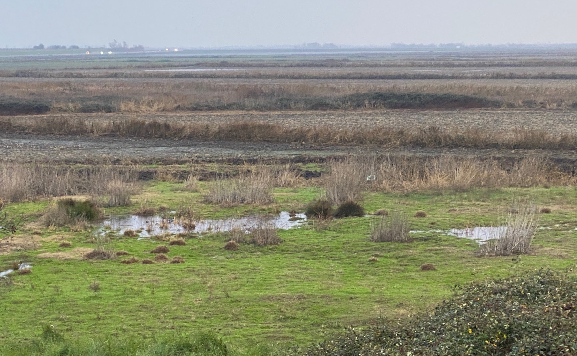
Groundwater seepage makes large swaths of the island too wet to farm. Courtesy MWD
In the five or so minutes it takes to cross the island by car, only a trained eye would notice the environmental challenges it faces. One such eye, Russ Ryan, senior engineer with Metropolitan Water District and Delta Island Adaptations project manager, takes me on a tour of the island. We start by driving up to the northern levee, climbing about twenty feet up a steep dirt road to the levee top. On the other side flows the South Mokelumne River, swollen from the tide and winter storms.
Bouldin Island currently lies between 20 and 25 feet below sea level and is estimated to have lost nearly half a billion cubic feet of land volume in the last 40 years. “The primary concern is to stop or reverse subsidence,” explains Brett Milligan, professor of landscape architecture at UC Davis and a leading facilitator during the restoration project’s planning process. “The more the land sinks, the more stress it puts on the infrastructure.”
Historically, farmers have grown corn and alfalfa on Bouldin’s peaty soils. When the peat is drained, it oxidizes, contributing to greenhouse gas emissions and thinning the layer of arable soil so much so that in some places groundwater seeps to the surface. Large swaths of land on the island are already too wet to farm.
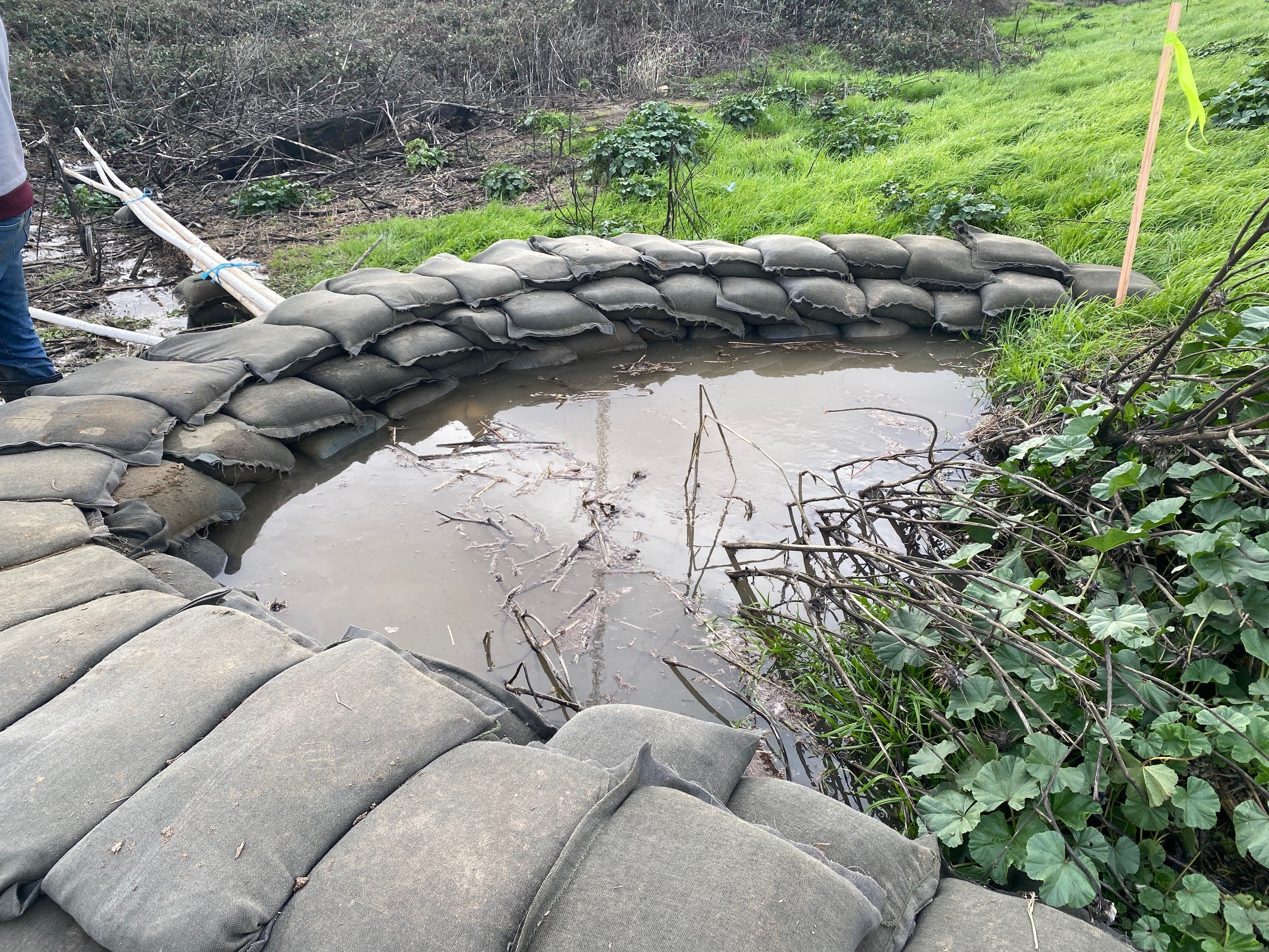
Levee boils can cause massive structural damage if not caught quickly. Photo: MWD
Even considering this extreme subsidence, Bouldin’s selection from the five as the target wasn’t made arbitrarily, but rather through a collaborative process with an iterative feedback loop. “There are two broad ways we did that,” Milligan says. The first was a technical advisory committee with representatives from Delta Stewardship Council, California Waterfowl Association, San Francisco Estuary Institute, and indigenous Tribes, among others. The second was a vigorous public process.
The committee established ten objectives for island selection including subsidence reversal, restoration opportunities, and water quality and supply. Members then ranked each island in order of their preferred choice and weighted the importance of each selection objective.
The selection process integrated outside feedback into the committee’s recommendations through surveys and a series of public meetings. “We’ve solicited input throughout the process,” says Milligan. “We’ve found a lot of alignment between the advisory committee and the public, including support both for ecological restoration and continued agriculture.”
In June of last year, the project progressed from selecting an island to developing a mosaic model that best addresses the diverse range of land-use needs, both public and private. The technical advisory committee and public meetings, some with 80-90 attendees, continue to inform progress.
Ryan attributes this feedback-heavy style of decision-making to a leadership change at Metropolitan Water District that prioritizes “innovation, inclusion, collaboration, and partnerships.” He points to new instances of cooperation in historically contentious relationships. “Restore the Delta has shown interest in participating in discussions and providing their input to help inform the work we’re doing,” he says. “We’ve traditionally always been on the other side of the fence.”
He recalls an “a-ha” moment that helped him bring down that fence between the District and Delta advocacy groups. “The thing that joins us is that water quality supports supply reliability, agricultural use, and the Delta environment as a whole,” he says. “If we can make a situation that creates better water quality, it is better for everybody.”
A Landscape Mosaic
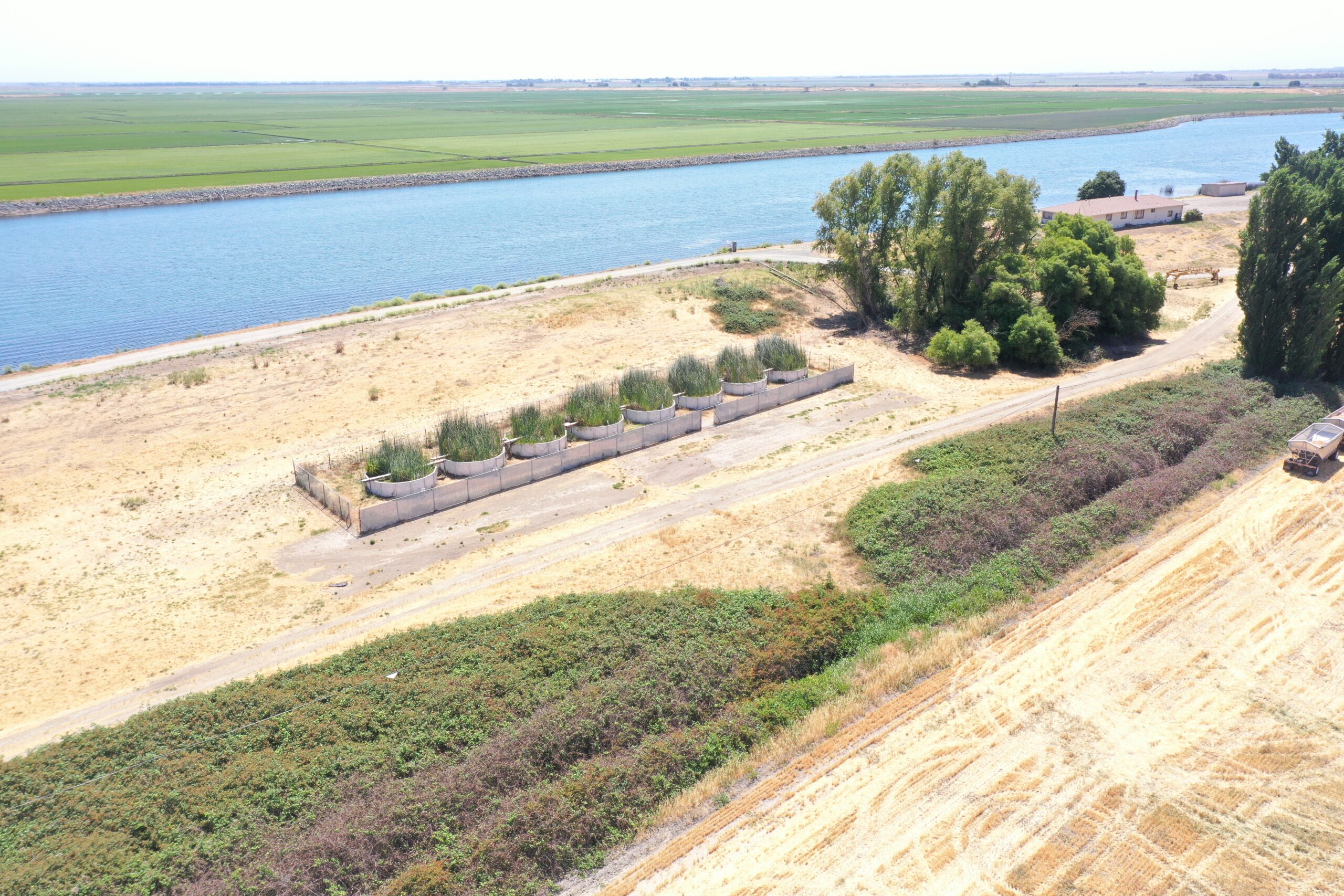
As we tour Bouldin Island, Ryan points out a line of short and stout cylinders. “Look how well they’re growing,” he says as he admires the tall thickets of tule reed spilling out over the tops. The cylinders house experimental floating wetlands, a research component informing plans for a new mosaic of land-uses for Bouldin. Data gathered on zooplankton populations (fish food) in the containers indicate that floating peat wetlands could be valuable fish habitat while also capturing carbon in a way reminiscent of tidal wetlands of the pre-reclamation Delta.
Experimental floating wetland cylinders offer promise for fish habitat on the island. Courtesy MWD
Ascertaining how best to balance ecological innovation like floating wetlands with demonstrated cultural and economic benefits of agriculture is at the crux of the current phase of Delta Islands Adaptions.
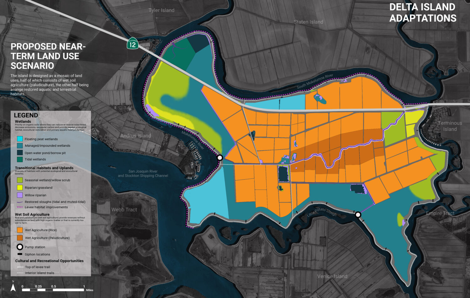
In September of last year, the project team presented six visions of a redesigned Bouldin Island to the technical advisory committee. They ranged from near-term scenarios (5-10 years) emphasizing agricultural production to long-term scenarios (25-50 years) focused on habitat restoration, leveraging climate adaptation incentives to make the transition economically viable.
After a five-month process of advisory and public feedback, the project team settled on one near-term proposal with several potential long-term contingency plans. “I think the most significant change is in the collective acknowledgement that we can’t know what the long-term scenario should or could be at this point in time,” says Milligan of the most recent developments. “So we moved towards a range of future scenarios: an adaptive playbook based on a set of if-then propositions.”
While the plan sets aside 50% of the island for continued agricultural uses, farmers currently practicing dry farming will have to come around to some new techniques and ideas to adapt to an increasingly wetter Delta due to both subsidence and sea-level rise. Corn and alfalfa will have to give way to rice and other wet agriculture on a new Bouldin.
Proposed near-term land use scenario for Bouldin Island presented at a technical meeting on February 15th, 2023. These plans will be revised for a public workshop schedule for April 25, 2023. Drawings: UC Davis Metamorphic Landscapes Lab & DIA team
“You would expect pushback,” says Ryan about proposing sweeping changes to farmers. But he has found otherwise when presenting the benefits of wet agriculture. While rice may not be able to match corn for raw yield, the carbon-capture economic benefit from rice, a crop that doesn’t contribute to subsidence and greenhouse gas emissions, offsets the loss from reduced total production.
A novel type of wetland farming, paludiculture, could also gain a foothold in the Delta through Bouldin Island. Through farming on wet or rewetted peat soils, paludiculture would minimize CO2 production while also producing harvestable biomass. A pilot project on Bouldin could provide a blueprint for larger-scale peatland carbon farming, according to the project website.
Boiling Over
Ryan stops his car on the levee along the western side of Bouldin Island and shows me a half-circle of sandbags piled three-high with the open end facing the levee slope. A PVC pipe extends from within the circle then down and away from the levee. “We call this a boil,” he says. A boil is when water from outside the island finds its way through a weakness in the levee structure and begins bubbling through on the other side. If the water is murky, it indicates that the surfacing water is bringing levee material with it. If it’s caught quickly, the material can be collected within the sandbag barrier while the water is drained through the pipe. If it’s not, the boil can turn into a major levee breach.
At Bouldin and many other Delta islands, land managers are racing to develop a more sustainable design before sea-level rise and acts of nature turn them into artificial lakes. “Time is critical,” says Ryan.
To move the project along, the team has relied on both transparency and participation from Delta communities and stewardship groups. “[The Metropolitan Water District] wants a long-term strategy for these islands,” says Milligan. “They will make the final decision, but they’re interested in being a good neighbor and retaining some of those aspects of the Delta that are valued by local communities.”
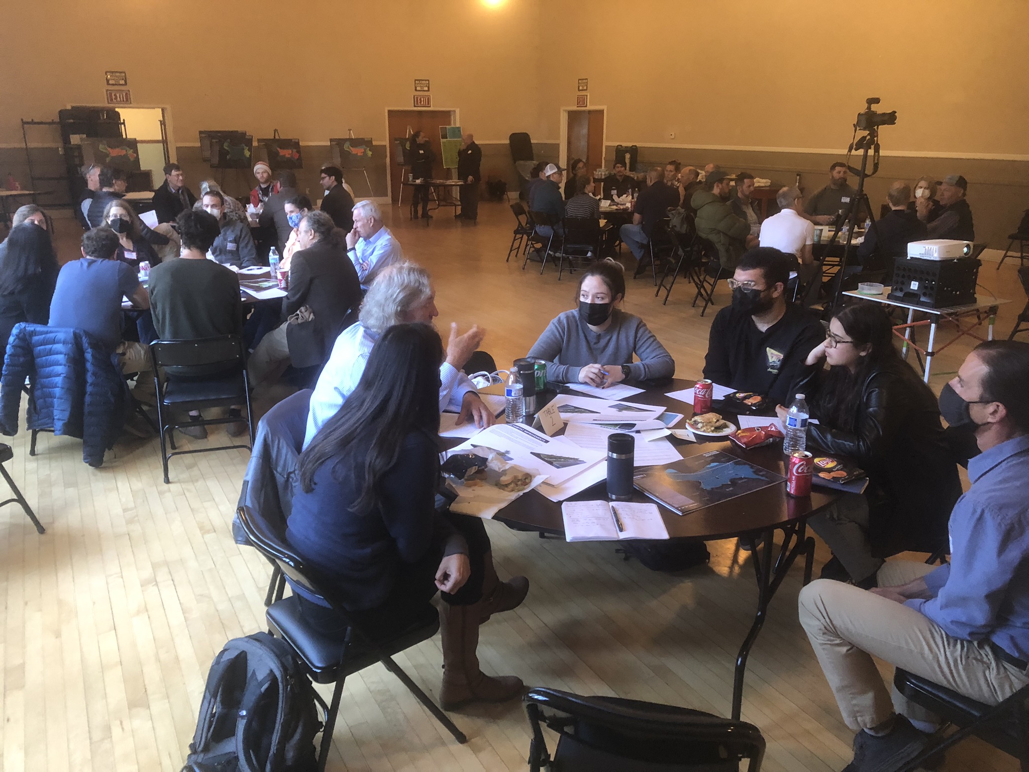
A public meeting about the future of Bouldin Island. Courtesy Brett Milligan
Public support for the project is broad, and majority opinion aligns well with the technical advisory committee’s stated priorities. Even so, mistrust of the outsider water district remains. Public comments like, “I don’t trust [Metropolitan Water District] at all,” and “how can the Metro. Water Dust. [sic] of L.A buy and own our Islands?” checker the public survey results.
“By bringing these people together you are hopefully initiating a social learning process,” says Milligan. “It’s very different from how we did things in the past: privilege one objective over the others. Generally, I think the benefit is in trying to integrate.”
A final public webinar is scheduled for April 25th, where the designs will be showcased for public input. After that, a Metropolitan Water District decision-maker’s meeting in July will give the final word on the future of Bouldin Island. It’s difficult to say what goes on behind closed doors, but, if the past is any guide, the collaboration and consideration that have defined the project so far should mean there won’t be any surprises.
Then it’s time to hit the ground running on remaking Bouldin Island before the levee boils over.
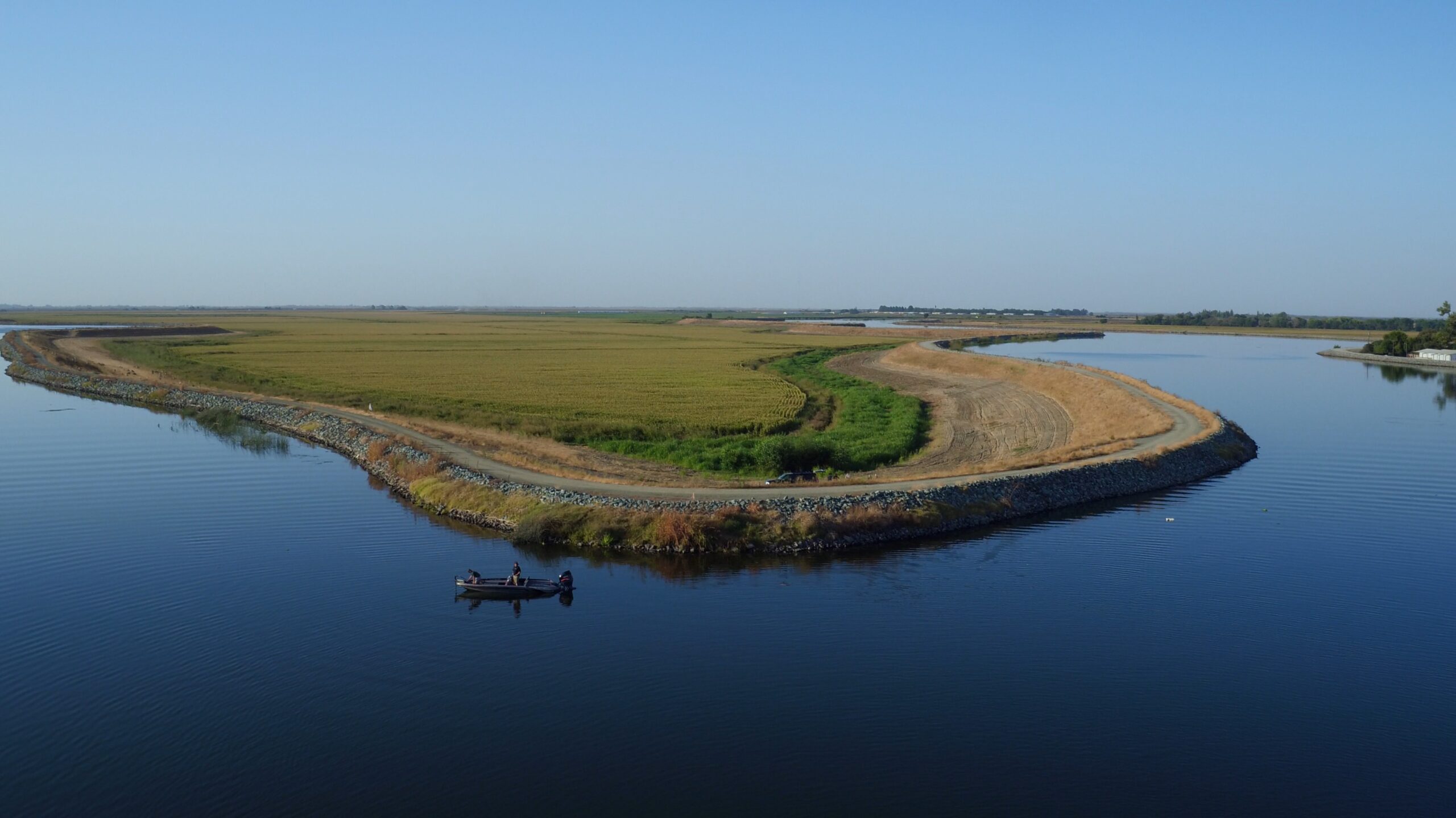
Top Photo: Aerial view of Bouldin Island. Courtesy MWD
Michael Hunter Adamson was born and partly raised in the Bay Area and spent his childhood balancing adventure with mischief. As an equally irresponsible adult he has worked for The Nature Conservancy, the arts and education nonprofit NaNoWriMo, taught English in Madrid-based High School equivalent, and volunteers with The Marine Mammal Center. As a writer for Estuary and the editor of the Bay Area Monitor, Michael employs his love for nature and his interest in people to help tell the unfolding story of the living Earth.
Our magazine’s media motto for many years has been “Where there’s an estuary, there’s a crowd.” The San Francisco Estuary is a place where people, wildlife, and commerce congregate, and where watersheds, rivers and the ocean meet and mix, creating a place of unusual diversity. In choosing to tell the...
Ever since the state and federal water projects were built in the 1930s and 1940s, California has captured snowmelt in foothill reservoirs, and moved the fresh water from dam releases and river outflows to parched parts of the state via aqueducts hundreds of miles long. A convoluted system of ancient...
Though the Clean Water Act did an amazing job of reducing wastewater and stormwater pollution of the San Francisco Estuary, some contaminants remain thorny problems. Legacy pollutants like mercury washed into the watershed from upstream gold mining, PCBs from old industrial sites, and selenium from agricultural drainage in the San...
Hothouse Earth
By Ariel Rubissow Okamoto
Photo by Megan Nguyen
Nothing could be stranger than sitting in the dark with thousands of suits and heels, watching a parade of promises to decarbonize from companies and countries large and small, reeling from the beauties of big screen rainforests and indigenous necklaces, and getting all choked up.
It was day two of the September 2018 Global Climate Action Summit in San Francisco when I felt it.
At first I wondered if I was simply starstruck. Most of us labor away trying to fix one small corner of the planet or another without seeing the likes of Harrison Ford, Al Gore, Michael Bloomberg, Van Jones, Jerry Brown – or the ministers or mayors of dozens of cities and countries – in person, on stage and at times angry enough to spit. And between these luminaries a steady stream of CEOs, corporate sustainability officers, and pension fund managers promising percentages of renewables and profits in their portfolios dedicated to the climate cause by 2020-2050.
I tried to give every speaker my full attention: the young man of Vuntut Gwichin heritage from the edge of the Yukon’s Arctic National Wildlife Refuge who pleaded with us not to enter his sacred lands with our drills and dependencies; all the women – swathed in bright patterns and head-scarfs – who kept punching their hearts. “My uncle in Uganda would take 129 years to emit the same amount of carbon as an American would in one year,” said Oxfam’s Winnie Byanyima.
“Our janitors are shutting off the lights you leave on,” said Aida Cardenas, speaking about the frontline workers she trains, mostly immigrants, who are excited to be part of climate change solutions in their new country.
The men on the stage, strutting about in feathers and pinstripes, spoke of hopes and dreams, money and power. “The notion that you can either do good or do well is a myth we have to collectively bust,” said New Jersey Governor Phil Murphy whose state is investing heavily in offshore wind farms.
“Climate change isn’t just about risks, it’s about opportunities,” said Blackrock sustainable investment manager Brian Deese.
But it wasn’t all these fine speeches that started the butterflies. Halfway through the second day of testimonials, it was a slight white-haired woman wrapped in an azure pashmina that pricked my tears. One minute she was on the silver screen with Alec Baldwin and the next she taking a seat on stage. She talked about trees. How trees can solve 30% of our carbon reduction problem. How we have to stop whacking them back in the Amazon and start planting them everywhere else. I couldn’t help thinking of Dr. Seuss and his truffala trees. Jane Goodall, over 80, is as fierce as my Lorax. Or my daughter’s Avatar.
Analyzing my take home feeling from the event I realized it wasn’t the usual fear – killer storms, tidal waves, no food for my kids to eat on a half-baked planet – nor a newfound sense of hope – I’ve always thought nature will get along just fine without us. What I felt was relief. People were actually doing something. Doing a lot. And there was so much more we could do.
As we all pumped fists in the dark, as the presentations went on and on and on because so many people and businesses and countries wanted to STEP UP, I realized how swayed I had let myself be by the doomsday news mill.
“We must be like the river, “ said a boy from Bangladesh named Risalat Khan, who had noticed our Sierra watersheds from the plane. “We must cut through the mountain of obstacles. Let’s be the river!”
Or as Harrison Ford less poetically put it: “Let’s turn off our phones and roll up our sleeves and kick this monster’s ass.”
4th California Climate Change Assessment Blues
by Isaac Pearlman
Since California’s last state-led climate change assessment in 2012, the Golden State has experienced a litany of natural disasters. This includes four years of severe drought from 2012 to 2016, an almost non-existent Sierra Nevada snowpack in 2014-2015 costing $2.1 billion in economic losses, widespread Bay Area flooding from winter 2017 storms, and extremely large and damaging wildfires culminating with this year’s Mendocino Complex fire achieving the dubious distinction of the largest in state history. California’s most recent climate assessment, released August 27th, predicts that for the state and the Bay Area, we can expect even more in the future.
The California state government first began assessing climate impacts formally in 2006, due to an executive order by Governor Schwarzenegger. California’s latest iteration and its fourth overall, includes a dizzying array of 44 technical reports; three topical studies on climate justice, tribal and indigenous communities, and the coast and ocean; as well as nine region-specific analyses.
The results are alarming for our state’s future: an estimated four to five feet of sea level rise and loss of one to two-thirds of Southern California beaches by 2100, a 50 percent increase in wildfires over 25,000 acres, stronger and longer heat waves, and infrastructure like airports, wastewater treatment plants, rail and roadways increasingly likely to suffer flooding.
For the first time, California’s latest assessment dives into climate consequences on a regional level. Academics representing nine California regions spearheaded research and summarized the best available science on the variable heat, rain, flooding and extreme event consequences for their areas. For example, the highest local rate of sea level rise in the state is at the rapidly subsiding Humboldt Bay. In San Diego county, the most biodiverse in all of California, preserving its many fragile and endangered species is an urgent priority. Francesca Hopkins from UC Riverside found that the highest rate of childhood asthma in the state isn’t an urban smog-filled city but in the Imperial Valley, where toxic dust from Salton Sea disaster chokes communities – and will only become worse as higher temperatures and less water due to climate change dry and brittle the area.
According to the Bay Area Regional Report, since 1950 the Bay Area has already increased in temperature by 1.7 degrees Fahrenheit and local sea level is eight inches higher than it was one hundred years ago. Future climate will render the Bay Area less suitable for our evergreen redwood and fir forests, and more favorable for tolerant chaparral shrub land. The region’s seven million people and $750 billion economy (almost one-third of California’s total) is predicted to be increasingly beset by more “boom and bust” irregular wet and very dry years, punctuated by increasingly intense and damaging storms.
Unsurprisingly, according to the report the Bay Area’s intensifying housing and equity problems have a multiplier affect with climate change. As Bay Area housing spreads further north, south, and inland the result is higher transportation and energy needs for those with the fewest resources available to afford them; and acute disparity in climate vulnerability across Bay Area communities and populations.
“All Californians will likely endure more illness and be at greater risk of early death because of climate change,” bluntly states the statewide summary brochure for California’s climate assessment. “[However] vulnerable populations that already experience the greatest adverse health impacts will be disproportionately affected.”
“We’re much better at being reactive to a disaster than planning ahead,” said UC Berkeley professor and contributing author David Ackerly at a California Adaptation Forum panel in Sacramento on August 27th. “And it is vulnerable communities that suffer from those disasters. How much human suffering has to happen before it triggers the next round of activity?”
The assessment’s data is publicly available online at “Cal-adapt,” where Californians can explore projected impacts for their neighborhoods, towns, and regions.


 The results are alarming for our state’s future: an estimated four to five feet of sea level rise and loss of one to two-thirds of Southern California beaches by 2100, a 50 percent increase in wildfires over 25,000 acres, stronger and longer heat waves, and infrastructure like airports, wastewater treatment plants, rail and roadways increasingly likely to suffer flooding.