Walking in the door of the fourth Ocean Climate Summit this May and finding Amy Hutzel, long-time chair of the committee in charge of implementing a conservation plan for the San Francisco Estuary, I asked her what she was doing out of her watershed? “Dipping my toe in the Pacific, “ she said. “For a while now, we’ve been working to build partnerships inland and offshore. It’s all one estuary.”
The water may be hotter in the Delta and colder in the Pacific, but scientists continue to reveal strong relationships and exchanges between the watershed, the estuary, and the ocean, and now, more than ever, with the atmosphere above them. Lots of things flow downriver and out the Golden Gate, or slosh back and forth between the Gulf of the Farallones and San Francisco Bay: nutrients, fish food, sediment, parcels of deoxygenated water, plastics, contaminants, juvenile crabs and flatfish, to name a few hitchhikers. Now all these things loom larger for water and resource managers, as rising sea levels promise to thrust the ocean deeper than ever into the heart of California.
“What we’re doing here is bringing the different communities of practice together,” said Maria Brown of the Greater Farallones National Marine Sanctuary, primary sponsor of the summit, in remarks at the all day May 17 event.
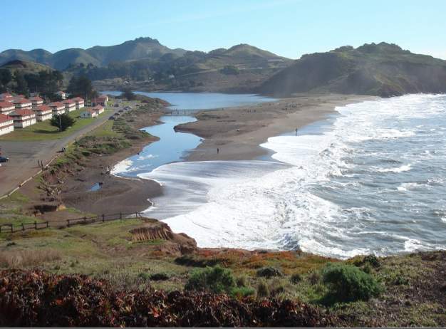
Fort Cronkhite on Marin County’s Pacific Coast. Photo: Sara Hutto
The summit was attended by141 resource managers, scientists, and activists concerned about the impacts of climate change on the ocean outside the Golden Gate. The enthusiasm for learning and sharing was palpable all day, even as attendees enjoyed brief lapses of attention staring out at a San Francisco waterfront view of swimmers, kayakers, ferries, and tankers traversing the chop stirred up by the breeze off the Pacific.
“The energy in this room, the collaborative spirit, the solution oriented approaches, are just awesome,” said the self-described “suit” from Washington DC brought in to open the event. Speaking about how the Bay Area’s work has been recognized nationally, even internationally, as a collaborative model, John Armor, acting director of NOAA’s marine sanctuaries program, said: “We need to use these marine sanctuaries, as places in the public spotlight that people care about, to communicate the need for solutions to our climate crisis.”
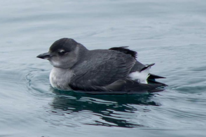
Over the course of the day, four major panels presented topics ranging from steps to climate-smart plans, policies, and funding to why 100,000 Cassin’s auklets died of starvation in 2014 and how the Army Corps of Engineers is trying to engineer more with nature than against it. Breaks between sessions included opportunities for attendees to provide input on various climate adaptation strategies pasted on the walls with blue tape.
Cassin’s auklet. Source: GFNMS surveys
The first panel revolved around the mechanics of how to do climate smart adaptation. Point Blue’s Ellie Cohen provided some basic context about the urgency of acting today, with a number of planetary tipping points already exceeded and summer sea ice melting faster than ever. “It’s right in our face now,” said Cohen. “We have to do more mitigation, adaptation, sequestration, and conservation.”
The next speaker said he was grateful to work in California because it’s been a proactive, rather than climate-denying state. Leadership is coming from the top, with governor’s orders that state agencies should take climate change into account when making any investment, said speaker Abe Doherty of the Ocean Protection Council. Doherty explained new funding mechanisms already in place to help fund adaptation, including enhanced infrastructure financing districts created by SB628. “We’re going to have to put together huge funding packages to deal with extreme events,” said Doherty.
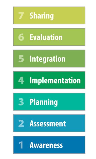
Lara Hansen of EcoAdapt followed with tools and steps for moving from awareness to planning and implementation. “Currently we’re lucky if 50% of plans are getting implemented,” she said, urging the audience not to think of climate change adaptation as an issue separate from others on the front burner of any resource management agency or municipality. “Any existing mechanism you can make climate savvy is better than creating something new; because you already have the personnel and resources in place to pursue implementation,” she said.
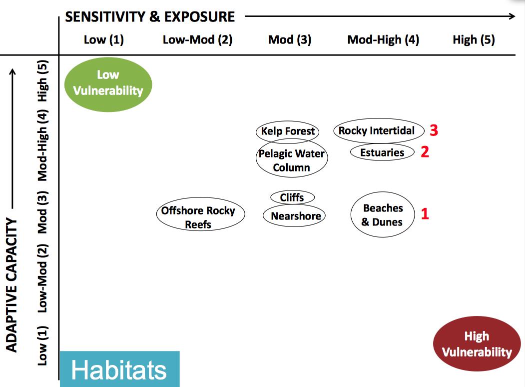
Sara Hutto of the Greater Farallones National Marine Sanctuary then described her organization’s recent assessment of the vulnerability of 44 different resources, ranging from habitats to specific species, and development of 78 strategies to protect them. “Assessment looks at sensitivity and exposure to climate change, and capacity to adapt,” she explained.
Assessment of sensitivity of coastal and offshore habitats. Chart: GFNMS
Results from the assessment pointed to three particularly vulnerable habitats – rocky intertidal, beaches and dunes, and estuaries. Bigger waves and higher sea levels threaten these habitats and the species that live in them. Marin and San Mateo counties, with their ocean coasts, have already prioritized these habitats in their own adaptation planning using the sanctuary’s assessment results.
“Given the acceleration of climate effects, everything is about trade offs now,” said Cohen in closing questions for the panel. “We may need to try some bigger, riskier adaptation projects like kelp reforestation.”
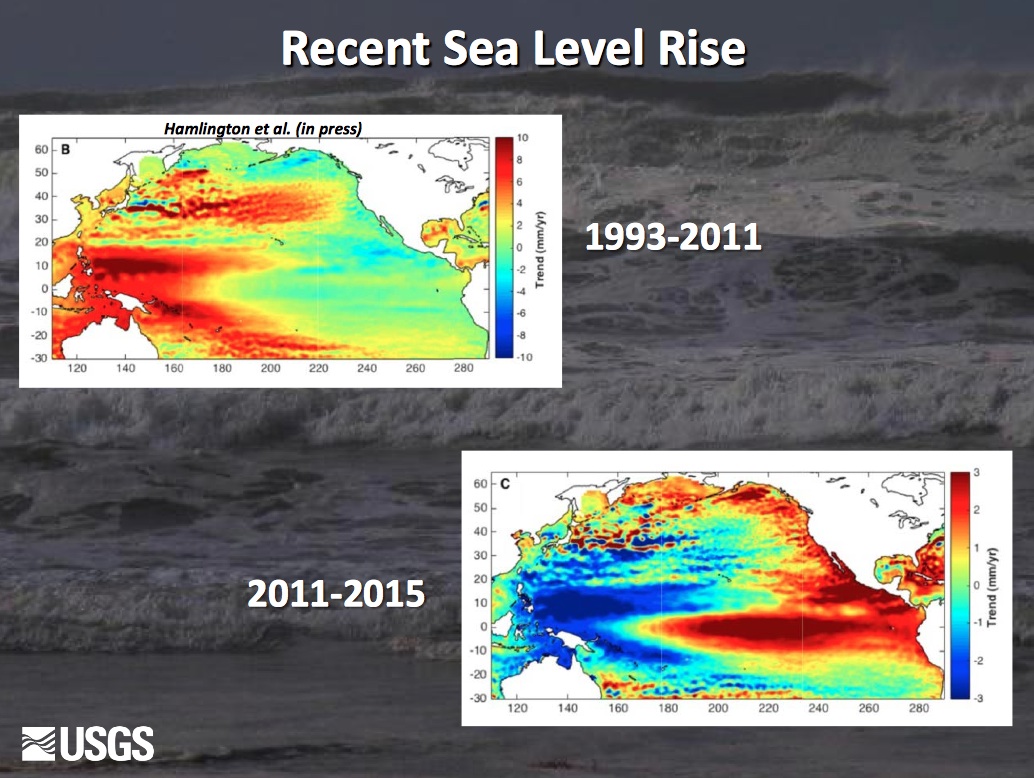
The second panel highlighted the latest science about what is going on in the ocean off the West Coast based on recent monitoring. The US Geological Survey’s Patrick Barnard confirmed that the global temperature increase over the last hundred years is fifty times faster than anytime in the last 20,000 years, and that scientists “are starting to get a handle on the response time for ice melt and resulting sea rise.” A multi-meter sea level rise is not only possible now but probable on the time scale of centuries, he said. “Even if we stop emitting today, we’re committed to two meters of SLR, and at least 10 meters if emissions continue at the same level,” he said. Barnard cited studies that have observed a steady increase in the size of waves along the West Coast. Strong reductions in sand transport to the coast have resulted in the area south of San Francisco being the most rapidly eroding stretch of shore in the state. “There’s been no evidence of a change in the size of El Niños, but perhaps the style of El Niño,” he added. “However, this winter was one of largest El Niños of the last century, and while we didn’t get the rain, we got the waves, and the most significant winter beach erosion ever documented in California.”
Source: Patrick Barnard
[space height=”4″]
John Largier from Bodega Marine Lab at UC Davis outlined the seasonality and spatial patterns in the pelagic habitat and then described climate-driven changes in the water properties that define changes in this offshore habitat, including sea surface warming, stratification of ocean layers (with upwelling of hypoxic water), ocean acidification (with changing carbonate chemistry affecting shell formation for important marine organisms), and increases in the intensity of coastal upwelling.
Source: NOAA Fisheries
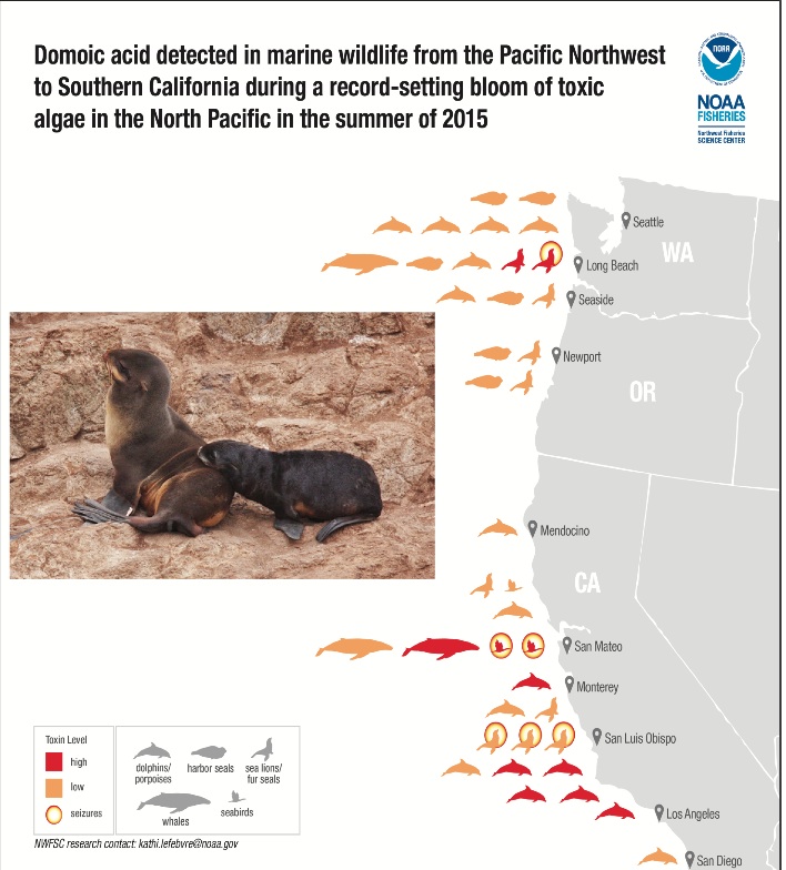
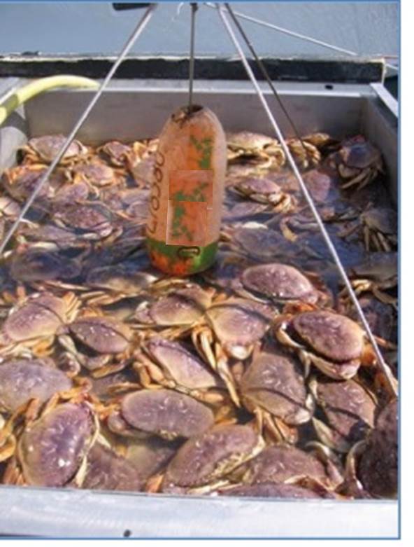
The Farallon Institute’s Bill Sydeman then detailed the harrowing die off of seabirds and other biological responses to what he called the last three year’s “unprecedented climate variability.” El Niño and the blob of warm water offshore conspired to compress habitat up against the coast, he said, reducing food for murres, auklets, seals, and other marine life. Weird conditions also introduced unusual phytoplankton with its toxin, domoic acid, to the ocean food web. The domoic acid in the crab, which was above a threshold considered safe for human consumption, led to an extended closure of the fishery. Another biological response noted by Sydeman is what he called “the massive tropicalization of the ecosystem.” No one expected to be seeing yellowfin tuna or Cook’s petrels from southern waters in our more northerly neck of the ocean. Bay Area residents have also been surprised by the sight of dolphins under the Golden Gate.
Two more speakers described yet more signs and indicators of climate-driven change in the ocean. Long term monitoring suggests that the spring transition time, when upwelling starts, has gotten earlier, said Point Blue’s Meredith Elliott. Monitoring of other indicators shows the percent per volume of krill in the water has gone down over time, while the volume of gelatinous zooplankton species has gone up. The latter likes warm water and are efficient at filtering phytoplankton, she said, outcompeting other species, and thus making ocean waters less productive.
Dungeness crab catch. Source: Carrie Pomeroy, Cal Sea Grant
California Sea Grant’s Carrie Pomeroy described how the shifts in biological communities in the ocean have affected the human communities that depend on salmon, crab, squid, and other fisheries for livelihood, food, and other benefits. Crab fisheries experienced unprecedented closures this past year due to the presence of high levels of a toxin in samples, for example. Squid, another example, have been moving into new areas where squid fishery permittees historically haven’t fished and that don’t have the shoreside infrastructure needed to handle the catch. “People accustomed to fishing in the south are having to learn how to work in the north,” said Pomeroy. Some communities are more mobile than others. “To adapt to these opportunities and challenges, management systems and coastal communities, as well as fishery participants, will have to be more flexible,” she said.
Lunch offered delectable curried chicken salad sandwiches and lemon bars, a picnic on the lawn overlooking the Bay, and lots of networking as people followed up on things they heard, or wanted to find out. The event, co-sponsored by 13 different government and research institutions and other local initiatives, had brought a wide range of ocean interests together. It also brought representatives from other marine sanctuaries off Hawaii, American Samoa, and Washington State to the summit so they could spread the word.
In the afternoon, a new panel tackled how to think globally but plan locally. Michael McCormick of the Governor’s Office of Planning and Research began by reviewing California’s shift from “should to shall” language in recent legislation (SB379) cueing local governments to plan for climate risk and adaptation. “We all understand that the best adaptation strategy is reducing greenhouse gas emissions,” said McCormick, a priority that may be partly accomplished by the premium placed on accommodating long term population change with more efficient growth and strong planning at the urban-rural interface. The State has been pushing all its agencies to consider adaptation in some way, he said, and is also providing “targeted funding to accelerate the process” of building adaptation and risk management into local and regional policy and program efforts. “Instead of asking local governments to plan from their current environmental settings, we are asking them to reflect the reality of a changing climate in long term planning,” said McCormick.
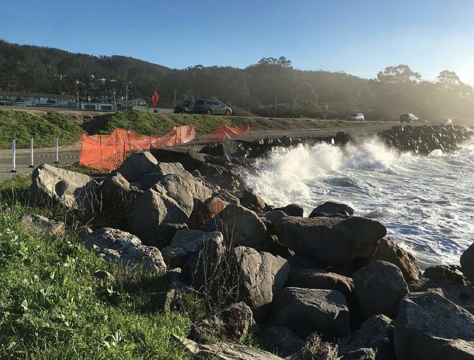
Site of pilot sand placement and adaptation project in San Mateo County at Surfer’s Beach. Source: Hilary Papendick, San Mateo County
Two planners from local government then gave the county perspective on how they were tackling projected sea level rise and climate change challenges. Hilary Papendick described San Mateo County’s efforts to coordinate a vulnerability assessment across more than twenty municipalities, including the infamous stretch of heavily eroding coast in Pacifica. “Our goal is to get a general understanding, by city and by unincorporated area, of where some of the clumps of risk are,” she said. Once the vulnerability assessment is complete, the county will shift to working on developing a coordinated strategy for reducing risks, and to supporting cities to ensure coordination.
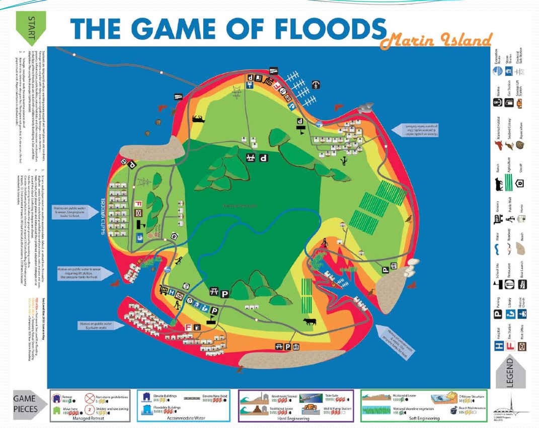
Game of Floods board. Source: Jack Liebster, Marin County
A big clump of risk also sits north of the Golden Gate on the Marin County shore, where the county has been reaching out to homeowners, landowners, and municipalities with a strong climate message. “We went where the people are, they have to be willing to pay for adaptation,” said the Marin County’s Jack Liebster. The county’s efforts include not only planning but also face time in living rooms with neighborhood groups and community meetings in which locals have to make difficult decisions in the “Game of Floods” (a new board game, developed by county and water district staff, which simulates choices to be made to escape rising seas). Marin’s small septic tank systems along the coast are a particular worry if they flood, said Liebster. “It’s not about the year the water is coming anymore, it’s about the water level,” he said, describing how the county has used the model (CcSMcS) developed by the US Geological Survey to get more climate smart. “Everything we’re geared to do now is linked to specific water levels.”
Wave, not water, levels, were a big concern for the next speaker, Ben Grant from SPUR, San Francisco Bay Area Planning and Urban Research. All day speakers had been talking about bigger, higher energy waves, and San Francisco’s Ocean Beach is on the receiving end. “This is not a someday problem, it’s a right now problem,” said Grant, describing rapid erosion threatening essential urban infrastructure along the shore, including sewer pipes, roads, and storm drains, as well as national park facilities and habitats. So many agencies and landowners were involved in this stretch of shoreline SPUR took the lead in developing what Grant called six “key moves” to adapt to the rising, crashing Pacific in an orderly manner. “The regulatory process is designed for single, one-time projects, and doesn’t fit the adaptive sequential model necessary for managed retreat,” he said. Key moves include the gradual closure of a section of the Great Highway, beach nourishment, low profile structural protection, and other steps, and are detailed on the SPUR web site as the project moves through city, county and national park approval hoops.
Source: Alicia Torregrosa, USGS
After a mid-afternoon break that went on a little too long, Andy Gunther of the Bay Area Ecosystems Climate Change Consortium beckoned everyone back for the home stretch of the summit – a look at some examples of climate smart projects linking the watershed to the sea. USGS researcher Alicia Torregrosa reminded the audience that fog is one way in which the atmosphere and climate interact with the ocean and estuary. Fog by definition is a cloud that actually touches the earth. Torregrosa said she still isn’t quite sure how climate change is impacting fog patterns along the West Coast, but she knows it’s a critical source of water and moisture to coastal ecosystems. “If we start subtracting fog from our scenarios it’s a very different future,” she said.
The future for the Army Corps has to include more alignment with nature and geography said the next two speakers. Mariah Abellera described the Corps’ SAGE program effort to take a more systems approach including “geomorphic engineering.” The program seeks to create a national community of practice within the Corps, rather than working project by project. “We’re trying to build regional pilots which integrate both green and gray solutions,” said Abellera. The Corps is also being more intentional about trying to engineer with, rather than against, natural processes, said Elizabeth Murray. “Different portions of our missions don’t always align, and [we’re trying to address that inefficiency] with better science and engineering on the ground,” she said.
In Bolinas, Corps plans to dredge a local lagoon to reduce sedimentation led Marin County Parks and its partners to investigate other solutions. The agency’s Veronica Pearson described efforts to tie historical research on watershed issues to planning for adaptation to sea level rise in the lagoon area. “One of our questions is how to reactivate the natural processes of an alluvial fan?” she said. Though the project is in its infancy, they’ve already documented watersheds, SLR projections, landslides, and historic conditions prior to human use in a site conditions report. By 2017, they hope to have three conceptual restoration designs to choose from, she said.
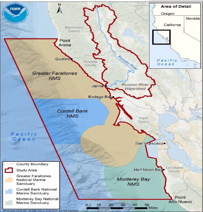
Natalie Cosentino-Manning didn’t have much choice, she said, when new mandates came down from NOAA’s Office of Habitat Conservation and the Obama administration for West Coast NOAA offices to showcase resilient and collaborative approaches to climate change and sea level rise. ‘The White House wanted a project that could bring NOAA, along with other offices within the Department of the Interior, together and demonstrate a new way of doing federal business, with results in 3-5 years and no funding,” she said. The local NOAA “line offices” (ocean service, weather, atmospheric research, satellite data, and marine fisheries services) rose to the challenge. They found a nexus in the Russian River estuary, with its 1,500-square mile watershed important to local water supply and fisheries and its 4,581 square mile area of open ocean in the federal marine sanctuary. “Once we were all sitting in the room together there was a definite aha moment, when we all came out of our silos and realized a number of our projects had shared objectives,” she said.
Focus area (North-Central California Coast and Russian River Watershed) for NOAA habitat blueprint planning. Source: Natalie Consentino-Manning, NOAA
Further work on the Russian River focus area has zeroed in on three places in the system: Lake Mendocino, still operated using a 1954 management manual that NOAA now hopes the Army Corps will update with improved rainfall predictions and river forecasting in sync with fish and human needs; Westminster Woods, a recreational area transitioning from diverting creek water for irrigation of sports fields to collecting runoff in water tanks for the same purpose, leaving creek flows for endangered coho salmon; and the coastal zone, where NOAA will apply improved modeling of coastal storm and sea level rise impacts.
The Russian River watershed was the first of ten “NOAA habitat blueprint” sites developed throughout the country since 2012, said Cosentino-Manning. The focus on the watershed and outer coast around the Farallones Islands also supports the White House’s “Resilient Lands and Waters Initiative.”
Just as the balmy summer evening beckoned from the outdoors and the audience was getting decidedly squirmy, the last panel came to a close. Farallones Sanctuary Superintendent Maria Brown returned to the podium to summarize the day, reiterating how much the community of climate-concerned people had grown, evolved, and become more climate-savvy than climate-smart.
“In the eight years since our first ocean climate summit, there’s been an amazing shift in knowledge and perspective,” said Brown. “After hearing that in the last 50 years our climate has warmed more than in the last two millennia, any of us could have thrown up our hands and walked away. But this summit tells me that if a small group becomes engaged and wants to think hard about something, they can change our future. We’re not victims, we’re allies.” ARO
Ariel Rubissow Okamoto is both today’s editor-in-chief and the founding editor of ESTUARY magazine (1992-2001). She enjoys writing in-depth, silo-crossing stories about water, restoration, and science. She’s a co-author of a Natural History of San Francisco Bay (UC Press 2011), frequent contributor of climate change stories to Bay Nature magazine, and occasional essayist for publications like the San Francisco Chronicle (see her Portfolio here). In other lives, she has been a vintner, soccer mom, and waitress. She lives in San Francisco close to the Bay with her architect husband Paul Okamoto.
Our magazine’s media motto for many years has been “Where there’s an estuary, there’s a crowd.” The San Francisco Estuary is a place where people, wildlife, and commerce congregate, and where watersheds, rivers and the ocean meet and mix, creating a place of unusual diversity. In choosing to tell the...
Ever since the state and federal water projects were built in the 1930s and 1940s, California has captured snowmelt in foothill reservoirs, and moved the fresh water from dam releases and river outflows to parched parts of the state via aqueducts hundreds of miles long. A convoluted system of ancient...
Though the Clean Water Act did an amazing job of reducing wastewater and stormwater pollution of the San Francisco Estuary, some contaminants remain thorny problems. Legacy pollutants like mercury washed into the watershed from upstream gold mining, PCBs from old industrial sites, and selenium from agricultural drainage in the San...
Hothouse Earth
By Ariel Rubissow Okamoto
Photo by Megan Nguyen
Nothing could be stranger than sitting in the dark with thousands of suits and heels, watching a parade of promises to decarbonize from companies and countries large and small, reeling from the beauties of big screen rainforests and indigenous necklaces, and getting all choked up.
It was day two of the September 2018 Global Climate Action Summit in San Francisco when I felt it.
At first I wondered if I was simply starstruck. Most of us labor away trying to fix one small corner of the planet or another without seeing the likes of Harrison Ford, Al Gore, Michael Bloomberg, Van Jones, Jerry Brown – or the ministers or mayors of dozens of cities and countries – in person, on stage and at times angry enough to spit. And between these luminaries a steady stream of CEOs, corporate sustainability officers, and pension fund managers promising percentages of renewables and profits in their portfolios dedicated to the climate cause by 2020-2050.
I tried to give every speaker my full attention: the young man of Vuntut Gwichin heritage from the edge of the Yukon’s Arctic National Wildlife Refuge who pleaded with us not to enter his sacred lands with our drills and dependencies; all the women – swathed in bright patterns and head-scarfs – who kept punching their hearts. “My uncle in Uganda would take 129 years to emit the same amount of carbon as an American would in one year,” said Oxfam’s Winnie Byanyima.
“Our janitors are shutting off the lights you leave on,” said Aida Cardenas, speaking about the frontline workers she trains, mostly immigrants, who are excited to be part of climate change solutions in their new country.
The men on the stage, strutting about in feathers and pinstripes, spoke of hopes and dreams, money and power. “The notion that you can either do good or do well is a myth we have to collectively bust,” said New Jersey Governor Phil Murphy whose state is investing heavily in offshore wind farms.
“Climate change isn’t just about risks, it’s about opportunities,” said Blackrock sustainable investment manager Brian Deese.
But it wasn’t all these fine speeches that started the butterflies. Halfway through the second day of testimonials, it was a slight white-haired woman wrapped in an azure pashmina that pricked my tears. One minute she was on the silver screen with Alec Baldwin and the next she taking a seat on stage. She talked about trees. How trees can solve 30% of our carbon reduction problem. How we have to stop whacking them back in the Amazon and start planting them everywhere else. I couldn’t help thinking of Dr. Seuss and his truffala trees. Jane Goodall, over 80, is as fierce as my Lorax. Or my daughter’s Avatar.
Analyzing my take home feeling from the event I realized it wasn’t the usual fear – killer storms, tidal waves, no food for my kids to eat on a half-baked planet – nor a newfound sense of hope – I’ve always thought nature will get along just fine without us. What I felt was relief. People were actually doing something. Doing a lot. And there was so much more we could do.
As we all pumped fists in the dark, as the presentations went on and on and on because so many people and businesses and countries wanted to STEP UP, I realized how swayed I had let myself be by the doomsday news mill.
“We must be like the river, “ said a boy from Bangladesh named Risalat Khan, who had noticed our Sierra watersheds from the plane. “We must cut through the mountain of obstacles. Let’s be the river!”
Or as Harrison Ford less poetically put it: “Let’s turn off our phones and roll up our sleeves and kick this monster’s ass.”
4th California Climate Change Assessment Blues
by Isaac Pearlman
Since California’s last state-led climate change assessment in 2012, the Golden State has experienced a litany of natural disasters. This includes four years of severe drought from 2012 to 2016, an almost non-existent Sierra Nevada snowpack in 2014-2015 costing $2.1 billion in economic losses, widespread Bay Area flooding from winter 2017 storms, and extremely large and damaging wildfires culminating with this year’s Mendocino Complex fire achieving the dubious distinction of the largest in state history. California’s most recent climate assessment, released August 27th, predicts that for the state and the Bay Area, we can expect even more in the future.
The California state government first began assessing climate impacts formally in 2006, due to an executive order by Governor Schwarzenegger. California’s latest iteration and its fourth overall, includes a dizzying array of 44 technical reports; three topical studies on climate justice, tribal and indigenous communities, and the coast and ocean; as well as nine region-specific analyses.
The results are alarming for our state’s future: an estimated four to five feet of sea level rise and loss of one to two-thirds of Southern California beaches by 2100, a 50 percent increase in wildfires over 25,000 acres, stronger and longer heat waves, and infrastructure like airports, wastewater treatment plants, rail and roadways increasingly likely to suffer flooding.
For the first time, California’s latest assessment dives into climate consequences on a regional level. Academics representing nine California regions spearheaded research and summarized the best available science on the variable heat, rain, flooding and extreme event consequences for their areas. For example, the highest local rate of sea level rise in the state is at the rapidly subsiding Humboldt Bay. In San Diego county, the most biodiverse in all of California, preserving its many fragile and endangered species is an urgent priority. Francesca Hopkins from UC Riverside found that the highest rate of childhood asthma in the state isn’t an urban smog-filled city but in the Imperial Valley, where toxic dust from Salton Sea disaster chokes communities – and will only become worse as higher temperatures and less water due to climate change dry and brittle the area.
According to the Bay Area Regional Report, since 1950 the Bay Area has already increased in temperature by 1.7 degrees Fahrenheit and local sea level is eight inches higher than it was one hundred years ago. Future climate will render the Bay Area less suitable for our evergreen redwood and fir forests, and more favorable for tolerant chaparral shrub land. The region’s seven million people and $750 billion economy (almost one-third of California’s total) is predicted to be increasingly beset by more “boom and bust” irregular wet and very dry years, punctuated by increasingly intense and damaging storms.
Unsurprisingly, according to the report the Bay Area’s intensifying housing and equity problems have a multiplier affect with climate change. As Bay Area housing spreads further north, south, and inland the result is higher transportation and energy needs for those with the fewest resources available to afford them; and acute disparity in climate vulnerability across Bay Area communities and populations.
“All Californians will likely endure more illness and be at greater risk of early death because of climate change,” bluntly states the statewide summary brochure for California’s climate assessment. “[However] vulnerable populations that already experience the greatest adverse health impacts will be disproportionately affected.”
“We’re much better at being reactive to a disaster than planning ahead,” said UC Berkeley professor and contributing author David Ackerly at a California Adaptation Forum panel in Sacramento on August 27th. “And it is vulnerable communities that suffer from those disasters. How much human suffering has to happen before it triggers the next round of activity?”
The assessment’s data is publicly available online at “Cal-adapt,” where Californians can explore projected impacts for their neighborhoods, towns, and regions.


 The results are alarming for our state’s future: an estimated four to five feet of sea level rise and loss of one to two-thirds of Southern California beaches by 2100, a 50 percent increase in wildfires over 25,000 acres, stronger and longer heat waves, and infrastructure like airports, wastewater treatment plants, rail and roadways increasingly likely to suffer flooding.