Though most don’t realize it, practically all Californians are linked to the Bay-Delta region via its triple function as a source of drinking water for some 27 million Californians, a critical water provider for the Golden State’s hefty agricultural industry, and a rich and unique ecosystem. But for those who live in the legal Delta zone – some 630,000 people – the braided weave of the Sacramento and San Joaquin Rivers and their maze of associated wetlands and levees provides a place of home, community, and recreation. And, as a recent study by the Delta Stewardship Council shows, climate change is tugging on the watery thread holding it all together.
“Two-thirds of Californians get their water from here, which is why climate change in the Delta has a large effect on statewide water availability,” says Harriet Lai Ross, assistant planning director with the Delta Stewardship Council. “There are over 750 species in the Delta, and we are part of the state’s three-trillion-dollar economy. [Our climate study] is the first time we’ve looked at all of the pieces comprehensively.”
The council’s overview reveals a grim outlook for the millions of people that are tethered to the region’s water: drought similar to that experienced in 2012-2016 will be five to seven times more likely by 2050. This will result in more severe and frequent water shortages and, as the report bluntly states, “lower reliability of Delta water exports.”
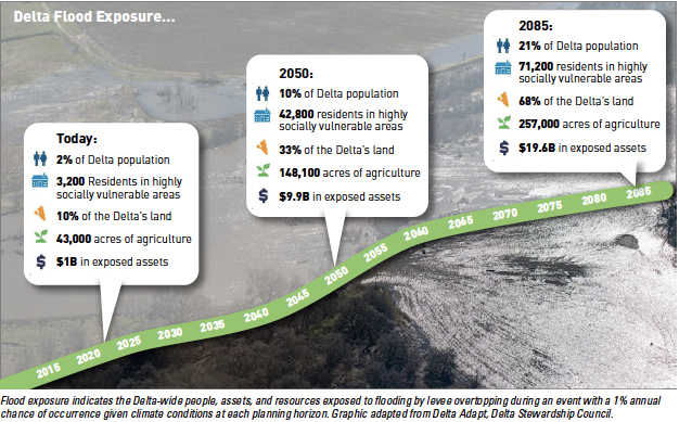
Flood exposure indicates the Delta-wide people, assets, and resources exposed to flooding by levee overtopping during an event with a 1 annual chance of occurrence given climate conditions at each planning horizon. Graphic adapted from Delta Adapt, Delta Stewardship Council.
Drought’s wet twin, flooding, is also projected to significantly impact the region which acts as a hub where tides, sea-level rise, river inflows, and storm surge all combine to churn the Delta’s muddy waters. The highest-flood-risk areas identified in the study include Suisun Marsh and its mosaic of wetlands managed by private duck clubs, the city and Port of Stockton, and subsided Delta islands.
Also at risk is a range of infrastructure including the I-5 freeway, Stockton’s Dameron Hospital, historically significant sites like the Sperry Flour Mill and Isleton’s Chinese and Japanese commercial districts, and — somewhat ironically, given their role in perpetuating climate change — roughly $800 million worth of oil and gas pipelines, wells, and stations scattered around the Delta.
But some impacts touch the Delta community in ways more significant than flooded infrastructure does. “The proliferation and increase in harmful algal blooms is a huge change,” says Barbara Barrigan-Parrilla, executive director of the nonprofit Restore the Delta. “I work with youth who are saying ‘When I grew up I used to go boating, fishing, swimming, but I don’t do that anymore,’” she says pointing out that the toxic blooms, exacerbated by warmer temperatures and reduced river flow due to drought, have altered their relationship with the Estuary. “And just think – if young adults are already saying this now, what is it going to be like for their kids?”
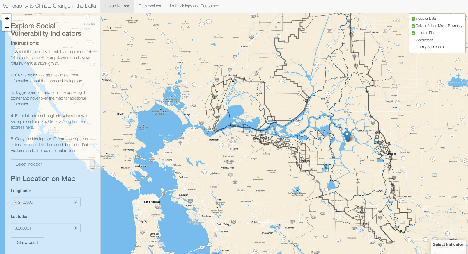
Screenshot from Delta social vulnerability mapping tool. See link below
As we’ve seen with the current pandemic, impacts are not felt equally during a disaster. The study found that almost two-thirds of residents at risk of flooding in 2050 are “socially vulnerable” — for example, those with asthma who suffer more from wildfire smoke; or families with elderly or young children who require more assistance during an evacuation. Along with minorities, renters, and low-income residents with less access to social services or air conditioning, people in these more-susceptible demographics are hit harder and take longer to recover from a flood or heat event than those in wealthier neighborhoods. The cities of Tracy and Stockton are projected to be hit particularly hard by increasing temperatures, and San Joaquin County (especially Lathrop and Stockton) by increased flooding.
After wrapping up the draft assessment period on March 16, Ross and her team were collecting public comments on the draft assessment, which will inform the next step to develop and prioritize resilience strategies for the region. According to Ross, key challenges are the usual suspects: lack of funding, and for the Delta Stewardship Council limited authority to implement the necessary changes on the ground which are the purview of a host of agencies ranging from Caltrans to PG&E to local city and county governments.
“I think we know what the answers are,” says Ross about needed climate adaptation actions. “A combination of flood-control improvements, targeted ecosystem restoration, and helping farmers continue to farm where it makes sense to, which is the heritage and primary land use of the Delta.”
Barrigan-Parrilla, however, is more frank about the need for action. “I don’t think there is room anymore to allow this to just be a report,” she says. “If this stops at a report and nothing changes it’s going to be hard to maintain the goodwill of the community – especially the younger generation.”
As if to punctuate the study’s findings, in the last few months the U.S. Bureau of Reclamation announced that agricultural water service contractors served by the Central Valley Project will initially receive only 5% of their allocations, and the State Water Project announced an initial estimate of just 10% of historical water deliveries to city and agricultural customers. Even with March rains, the most recent U.S. Drought Monitor report shows that 99% of California is “abnormally dry” and 30% is in “extreme” or “exceptional” drought. All of which starkly underlines the first sentence of the 200-page draft report: “The time to act is now.”
Isaac Pearlman covers sea level rise, flooding, and other topics for ESTUARY. A Bay Area native, Isaac's writing is informed by his master's degree in environmental science, as well as many adventures from living and working in South America, Europe, and Southeast Asia. His stories and essays have been featured in Earth Island Journal, the Progressive Populist, and Ecosystems among other outlets. https://isaacpearlman.wordpress.com
Our magazine’s media motto for many years has been “Where there’s an estuary, there’s a crowd.” The San Francisco Estuary is a place where people, wildlife, and commerce congregate, and where watersheds, rivers and the ocean meet and mix, creating a place of unusual diversity. In choosing to tell the...
Ever since the state and federal water projects were built in the 1930s and 1940s, California has captured snowmelt in foothill reservoirs, and moved the fresh water from dam releases and river outflows to parched parts of the state via aqueducts hundreds of miles long. A convoluted system of ancient...
Though the Clean Water Act did an amazing job of reducing wastewater and stormwater pollution of the San Francisco Estuary, some contaminants remain thorny problems. Legacy pollutants like mercury washed into the watershed from upstream gold mining, PCBs from old industrial sites, and selenium from agricultural drainage in the San...
Hothouse Earth
By Ariel Rubissow Okamoto
Photo by Megan Nguyen
Nothing could be stranger than sitting in the dark with thousands of suits and heels, watching a parade of promises to decarbonize from companies and countries large and small, reeling from the beauties of big screen rainforests and indigenous necklaces, and getting all choked up.
It was day two of the September 2018 Global Climate Action Summit in San Francisco when I felt it.
At first I wondered if I was simply starstruck. Most of us labor away trying to fix one small corner of the planet or another without seeing the likes of Harrison Ford, Al Gore, Michael Bloomberg, Van Jones, Jerry Brown – or the ministers or mayors of dozens of cities and countries – in person, on stage and at times angry enough to spit. And between these luminaries a steady stream of CEOs, corporate sustainability officers, and pension fund managers promising percentages of renewables and profits in their portfolios dedicated to the climate cause by 2020-2050.
I tried to give every speaker my full attention: the young man of Vuntut Gwichin heritage from the edge of the Yukon’s Arctic National Wildlife Refuge who pleaded with us not to enter his sacred lands with our drills and dependencies; all the women – swathed in bright patterns and head-scarfs – who kept punching their hearts. “My uncle in Uganda would take 129 years to emit the same amount of carbon as an American would in one year,” said Oxfam’s Winnie Byanyima.
“Our janitors are shutting off the lights you leave on,” said Aida Cardenas, speaking about the frontline workers she trains, mostly immigrants, who are excited to be part of climate change solutions in their new country.
The men on the stage, strutting about in feathers and pinstripes, spoke of hopes and dreams, money and power. “The notion that you can either do good or do well is a myth we have to collectively bust,” said New Jersey Governor Phil Murphy whose state is investing heavily in offshore wind farms.
“Climate change isn’t just about risks, it’s about opportunities,” said Blackrock sustainable investment manager Brian Deese.
But it wasn’t all these fine speeches that started the butterflies. Halfway through the second day of testimonials, it was a slight white-haired woman wrapped in an azure pashmina that pricked my tears. One minute she was on the silver screen with Alec Baldwin and the next she taking a seat on stage. She talked about trees. How trees can solve 30% of our carbon reduction problem. How we have to stop whacking them back in the Amazon and start planting them everywhere else. I couldn’t help thinking of Dr. Seuss and his truffala trees. Jane Goodall, over 80, is as fierce as my Lorax. Or my daughter’s Avatar.
Analyzing my take home feeling from the event I realized it wasn’t the usual fear – killer storms, tidal waves, no food for my kids to eat on a half-baked planet – nor a newfound sense of hope – I’ve always thought nature will get along just fine without us. What I felt was relief. People were actually doing something. Doing a lot. And there was so much more we could do.
As we all pumped fists in the dark, as the presentations went on and on and on because so many people and businesses and countries wanted to STEP UP, I realized how swayed I had let myself be by the doomsday news mill.
“We must be like the river, “ said a boy from Bangladesh named Risalat Khan, who had noticed our Sierra watersheds from the plane. “We must cut through the mountain of obstacles. Let’s be the river!”
Or as Harrison Ford less poetically put it: “Let’s turn off our phones and roll up our sleeves and kick this monster’s ass.”
4th California Climate Change Assessment Blues
by Isaac Pearlman
Since California’s last state-led climate change assessment in 2012, the Golden State has experienced a litany of natural disasters. This includes four years of severe drought from 2012 to 2016, an almost non-existent Sierra Nevada snowpack in 2014-2015 costing $2.1 billion in economic losses, widespread Bay Area flooding from winter 2017 storms, and extremely large and damaging wildfires culminating with this year’s Mendocino Complex fire achieving the dubious distinction of the largest in state history. California’s most recent climate assessment, released August 27th, predicts that for the state and the Bay Area, we can expect even more in the future.
The California state government first began assessing climate impacts formally in 2006, due to an executive order by Governor Schwarzenegger. California’s latest iteration and its fourth overall, includes a dizzying array of 44 technical reports; three topical studies on climate justice, tribal and indigenous communities, and the coast and ocean; as well as nine region-specific analyses.
The results are alarming for our state’s future: an estimated four to five feet of sea level rise and loss of one to two-thirds of Southern California beaches by 2100, a 50 percent increase in wildfires over 25,000 acres, stronger and longer heat waves, and infrastructure like airports, wastewater treatment plants, rail and roadways increasingly likely to suffer flooding.
For the first time, California’s latest assessment dives into climate consequences on a regional level. Academics representing nine California regions spearheaded research and summarized the best available science on the variable heat, rain, flooding and extreme event consequences for their areas. For example, the highest local rate of sea level rise in the state is at the rapidly subsiding Humboldt Bay. In San Diego county, the most biodiverse in all of California, preserving its many fragile and endangered species is an urgent priority. Francesca Hopkins from UC Riverside found that the highest rate of childhood asthma in the state isn’t an urban smog-filled city but in the Imperial Valley, where toxic dust from Salton Sea disaster chokes communities – and will only become worse as higher temperatures and less water due to climate change dry and brittle the area.
According to the Bay Area Regional Report, since 1950 the Bay Area has already increased in temperature by 1.7 degrees Fahrenheit and local sea level is eight inches higher than it was one hundred years ago. Future climate will render the Bay Area less suitable for our evergreen redwood and fir forests, and more favorable for tolerant chaparral shrub land. The region’s seven million people and $750 billion economy (almost one-third of California’s total) is predicted to be increasingly beset by more “boom and bust” irregular wet and very dry years, punctuated by increasingly intense and damaging storms.
Unsurprisingly, according to the report the Bay Area’s intensifying housing and equity problems have a multiplier affect with climate change. As Bay Area housing spreads further north, south, and inland the result is higher transportation and energy needs for those with the fewest resources available to afford them; and acute disparity in climate vulnerability across Bay Area communities and populations.
“All Californians will likely endure more illness and be at greater risk of early death because of climate change,” bluntly states the statewide summary brochure for California’s climate assessment. “[However] vulnerable populations that already experience the greatest adverse health impacts will be disproportionately affected.”
“We’re much better at being reactive to a disaster than planning ahead,” said UC Berkeley professor and contributing author David Ackerly at a California Adaptation Forum panel in Sacramento on August 27th. “And it is vulnerable communities that suffer from those disasters. How much human suffering has to happen before it triggers the next round of activity?”
The assessment’s data is publicly available online at “Cal-adapt,” where Californians can explore projected impacts for their neighborhoods, towns, and regions.


 The results are alarming for our state’s future: an estimated four to five feet of sea level rise and loss of one to two-thirds of Southern California beaches by 2100, a 50 percent increase in wildfires over 25,000 acres, stronger and longer heat waves, and infrastructure like airports, wastewater treatment plants, rail and roadways increasingly likely to suffer flooding.