The 2017 update to the Central Valley Flood Protection Plan, to be released later this summer, radically revises the flood control strategies that have prevailed for more than a century. The plan recognizes the connections between the flood system, the water system and the ecosystem, and relies less on levees and more on floodplain restoration to upgrade the state’s aging and inadequate flood control infrastructure.


When the Central Valley Flood Protection Board adopts the 2017 Update to its Flood Protection Plan later this summer it be another twist in the serpentine evolution of California’s approach to flood management. While the primary goal of the plan is to improve flood risk management, it emphasizes the integration of ecosystem functions and native habitats into the flood management system, as well as promoting multi-benefit projects.
“It’s an exciting time to be in flood control,” says Diana Jacobs of the Sacramento River Trust, who has worked in the field since Governor Jerry Brown’s first administration.

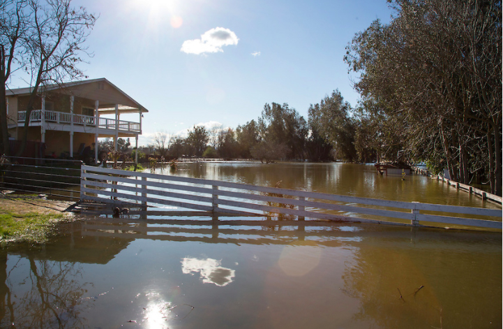
“It’s a remarkable evolution for the state’s flood control efforts, which began in the 1800s when debris from hydraulic mining filled the valley’s rivers and caused flooding. The state Reclamation Board was established in 1911 and spent most of the 20th century building levees and draining land for agriculture and development. In 2008, shortly after Hurricane Katrina demonstrated the devastating potential of floodwaters, a California court decision held the state liable for damage caused by the failure of local agencies to provide adequate flood protection. To reduce the state’s potential exposure, the legislature reconstituted the Board as the Central Valley Flood Protection Board and directed it to adopt a long-range strategic plan for maintaining and operating the valley’s complex, largely antiquated flood control system, to be developed by the Department of Water Resources and updated every five years. The 2017 update is the first since the initial plan was adopted in 2012. The Board will hold meetings and workshops on the update throughout the summer.
“The refinements, additional modeling, inclusion of climate change, and the new sections that have been added are moving us toward comprehensive management of a disparate and aging infrastructure that hasn’t been carefully looked at in the past,” says the Board’s Executive Officer Leslie Gallagher. “We are recognizing that the flood system is also the water system is also the habitat for lots of endangered species. The goal is still safety first, but we recognize that the system is used for all these other purposes.”
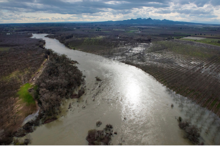
According to Board member Tim Ramirez, “There’s nothing the state could do that would be more cost-effective or happen more quickly than expand the floodway corridors and allow for increased capacity, because in the end that’s going to create better protection behind the levees, and also create more habitat for the species that depend on the rivers.” Restoring floodplains can also help water supply management, both through groundwater recharge and by allowing reservoirs to store more water rather than maintain excess rainy day capacity.
Among the documents DWR developed along with the flood plan update is a Conservation Strategy that includes goals and measurable objectives for improving ecosystem functions by integrating restoration with flood risk reduction projects where feasible. “The Conservation Strategy is an amazing, fantastic compendium of where we are at,” says Jacobs. “It picks up where CALFED left off on ecosystem restoration, adds a lot of new science on Central Valley rivers, and integrates it with floods.”
At press time the strategy was not an official part of the update, merely a supporting document. However, Ramirez and others are optimistic that it will be included as part of the plan that the Board ultimately adopts. “The conservation community wants the Board, in its independent capacity, to make DWR go the extra inch and say the strategy is part of the plan,” says Jacobs.
The opportunities and incentives for reconfiguring the flood control system are colossal: most of it was built piecemeal more than half a century ago. The Army Corps of Engineers has designated large portions of the system as out of compliance with federal operations and management requirements, leaving the state ineligible for rehabilitation funding in the event of a flood.
As to how the Board will realize the plan’s vision, “That’s the billion dollar question,” says Gallagher. The plan does not give the state any additional authority over local agencies, general plans, or zoning ordinances that would allow it to limit development in the floodplain. No problem, says Ramirez: “Obviously the valley’s going to continue to develop over time but it needs to be done in places that don’t put the state at risk for greater liability, and in the end that’s our decision. The Board is a permitting agency like BCDC or the Coastal Commission; people have to come to us if they want to do something that’s in the State Plan of Flood Control, and we can say no.”
Initially, floodplain restoration efforts will focus on downstream areas. “It doesn’t do any good to make floodplains at the top of the system if downstream capacity is limited,” explains Ramirez. There are already projects in the works at the Yolo Bypass on the Sacramento River and at Paradise Cut on the San Joaquin River.
The update includes a financial strategy to meet the plan’s price tag of $17-$21 billion over 30 years. “It’s a big number,” says Gallagher “If we want this level of protection we are going to have to pay for it and everybody’s going to have to pitch in.”
“This isn’t easy,” says Gallagher. “These are very complex systems. When you have things as disparate as agricultural, urban and environmental uses in the flood plain, all attached together in a way that has to work, its a big step for the state to be moving in this direction.”
Contact: Leslie Gallagher; Tim Ramirez
Related Links
Central Valley Flood Protection Plan Draft Update 2017
Related Estuary Stories
Back to the Bones of the Delta 3/17 (restoring processes-flooding)


 The results are alarming for our state’s future: an estimated four to five feet of sea level rise and loss of one to two-thirds of Southern California beaches by 2100, a 50 percent increase in wildfires over 25,000 acres, stronger and longer heat waves, and infrastructure like airports, wastewater treatment plants, rail and roadways increasingly likely to suffer flooding.