 DOWNLOAD the September 2016 Issue PDF
Nutrient Nuances Modeled
By Lisa Owens-Viani
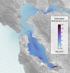
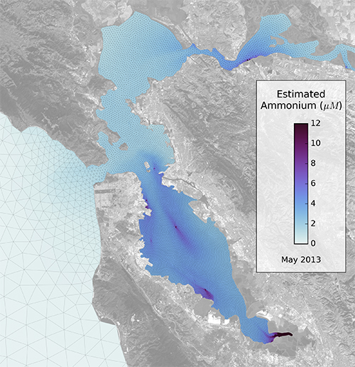
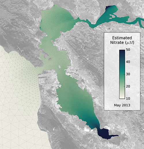
San Francisco Bay is becoming less opaque as the sediments power-washed into the Estuary by miners so long ago gradually disperse. This lets sunlight penetrate deeper into the water, creating more favorable conditions for the kind of problematic algal blooms that can shut down crab fisheries and keep people and their pooches out of the water. Scientists have collaborated on some new computer models, however, that may help them predict where and when nutrients, like nitrogen and phosphate from discharges and runoff, may exacerbate the situation.
 “It’s still a turbid estuary,” says the San Francisco Estuary Institute’s Dave Senn. “But there’s been a relaxation of some of the things keeping a lid on algae growth.”
Scientists at SFEI are collaborating with the US Geological Survey and a Dutch research institute to build and share new, open-source, state of the art models of local nutrient dynamics based not only on hydrology but also on physics, chemistry, and biology. This ambitious modeling endeavor is being funded by the Regional Monitoring Program and the San Francisco Bay Nutrient Management Strategy.
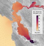 Senn says the new models will be important tools for quantifying how excess nutrients influence water quality today, as well as for forecasting conditions under future scenarios, like what could happen to algae growth if sediment concentrations go down by another 50 percent. The models can help investigate the effects of seasonal and spatial variations in turbidity, the mixing by the strong tides in the Bay, and how the abundance of grazing organisms like clams keep algal growth in check.
The models will also help wastewater managers answer questions about actions they might take to mitigate or prevent impairment of the Bay in certain areas, and to identify nutrient concentrations that will be protective of ecosystem health, says Senn. Data on past algal blooms and other events are being used to calibrate and validate the models, which can then be re-run to test various management strategies, says SFEI’s Rusty Holleman.
 “If you see in the observational record that one day chlorophyll was alarmingly high in a spot, and then two months later not there at all, you could do a lot of reasoning based just on those observations,” says Holleman. “But if we can replicate that in a model, we can pick apart the factors and then test hypotheticals.”
Other specific issues the models could help elucidate are the spatial influence of nutrient loads from each nutrient source, including wastewater outfalls and nonpoint sources like storm drains and creeks, and how sloughs and ponds at the margins of the Bay affect water quality, among many others.
East Bay Dischargers Authority General Manager Mike Connor says information gleaned from the new models could also help wastewater managers figure out if some parts of the Bay will need to be managed differently than others. “Right now the North and South Bays have very similar nutrient levels but very different chlorophyll responses. We suspect the newly restored salt ponds in the South Bay may be acting as little reactors that grow algae and then feed it back into the Bay, but these kinds of processes may work differently in the North Bay. The models will allow us to test different potential management strategies without having to do giant experiments in the Bay.”
The Regional Water Board’s Tom Mumley says his agency is developing nutrient water quality objectives and permit implementation requirements. “Given the significant costs of potential current and future nutrient management scenarios, our modeling investments will definitely yield decision dividends.”
Ultimately, say Connor and Senn, the modeling results could be used to help structure a nutrient credit or trading system for wastewater dischargers in the Bay, similar to carbon trading. But a key difference is that the atmosphere is well mixed with carbon from emissions around the globe — while the Bay is not well mixed. “You’re not going to influence summertime nutrient levels in South Bay by adjusting the inputs in Suisun Bay,” says Senn. “But that’s where the modeling can be really helpful; it takes into account nutrient inputs from each location and their transport and biogeochemical reactions when estimating how they contribute to nutrient concentrations in space and time.”
CONTACT:
Dave Senn
Rusty Holleman
Mike Connor
NEXT STORY: Teachable Moments


 The results are alarming for our state’s future: an estimated four to five feet of sea level rise and loss of one to two-thirds of Southern California beaches by 2100, a 50 percent increase in wildfires over 25,000 acres, stronger and longer heat waves, and infrastructure like airports, wastewater treatment plants, rail and roadways increasingly likely to suffer flooding.