
 The curving swath of waterways and marshes that stretches from Suisun Marsh, northeast up the Sacramento River—referred to by presenters on Tuesday afternoon as the North Delta Arc—are prime spawning, growing, and foraging habitat for native estuarine and freshwater fish. Yet fish as well as waterfowl in the area will face challenges as sea level rises, other effects of climate change take hold, and people continue to modify the region. Three presenters from UC Davis’s Center for Watershed Sciences looked ahead at how to best support the region’s ecosystem in the decades to come.
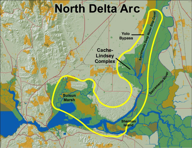
Research led by John Durand with UC Davis has examined what makes the North Delta Arc—including Cache and Lindsey sloughs and Suisun Marsh—successful habitat for fish. Their preliminary research identified several mechanisms critical to supporting resiliency in the region’s ecosystem, including habitat complexity, tidal interaction with the shore, water quality dynamics, and interconnected habitats. They described the North Delta Arc as a mosaic of riparian habitat, mudflats, rip-rapped levees, tule stands, and emergent vegetation bathed in highly variable tides. Tidal exchange of sediment and phytoplankton in the water help maintain a variety of habitats that may be beneficial to both native and desirable invasive species. The researchers noted that phytoplankton growth appears to be most concentrated in the upper reaches of dead-end sloughs, possibly contributing to the local food web. Because these sloughs are well connected to the main channels of the estuary, aquatic life can readily move between them in search of food or refuge. UC Davis researchers aim to learn how these aspects of the ecosystem function in order to inform plans for tidal marsh restorations throughout the Delta said Denise Decarion, a project collaborator who presented on behalf of Durand.
Integral to the North Delta Arc’s past and future is historic Suisun Marsh—the largest remaining estuarine tidal marsh on the West Coast. Presenter Amber Manfree, coeditor of the forthcoming book “Suisun Marsh—Ecological History and Possible Futures,” outlined different approaches for managing the wetlands. Nearly all of the marsh has been affected over the past 100 years by the construction of dikes, canals, roads, floodgates, and upstream diversions. For this reason, Manfree said, heavy human intervention is required to maintain the current state of the marsh. Pressures from sea level rise and changing precipitation patterns will demand new approaches to managing the marsh over the coming century. According to one model, the 100-centimeter rise in sea level anticipated by 2100 could render most of Suisun Marsh a subtidal zone. The marsh could be preserved as it is today with the same goals as the Suisun Marsh Plan—maintaining current levels of duck hunting, open space, recreation, endangered species protection, and urban area buffers from sea level rise. This would require traditional levees with tidal gates to keep the rising waters literally “at bay.” But over time, the amount of diking required to maintain such a “fortress marsh” would likely become financially unsustainable. Another future could be a flooded marsh, which would ensue if any of the dikes breached in an earthquake or extreme storm. Such an event would transform much of the marsh into tidal or sub-tidal habitat. But if soil-building processes could keep pace with the rising sea level, tidal marsh habitats would eventually develop. A third option would be to manage the area as a tidal marsh, with diverse habitats, and planned wildlife corridors. This would require significant funds for conservation and limiting duck hunting activities. A final option, which Manfree calls an “ecomarsh,” would prioritize the needs of wildlife and employ every means to conserve habitat over the long term, including building up soil. “Addressing expected changes sooner than later,” said Manfree, who is completing her PhD at UC Davis, “leaves more options open for us.”
Some 40 miles upstream of Suisun Marsh lies the Yolo Bypass, which diverts floodwaters from the Sacramento River into the Sacramento-San Joaquin River Delta and ends near Cache Slough. As part of the Bay Delta Conservation Plan, the proposed Conservation Measure #2 would allow more floodwaters to reach the Bypass and adjacent Yolo and Solano counties. UC Davis’s Robyn Suddeth has modeled the impacts of such increased flooding on regional agriculture, wildlife, and recreation. While critical for managing floodwaters, the bypass is important to aquatic species that migrate along the waterway. Chinook salmon and splittail find plentiful food here. Waterfowl and migrant birds stop here during their journey along the Pacific Flyway. Because the bypass already supports so much wildlife and covers such a large area, it is often pointed to as a rare place within the Bay Delta system with great potential for habitat restoration. Though extremely valuable to wildlife, the floodplain is equally prized by farmers. Rice is the primary crop, but this landscape is also used for grazing and to grow corn and tomatoes. Like Suisun Marsh, the bypass is popular among duck hunters, and contains a state wildlife area. But as flood patterns change, said Suddeth, the question is whether “it’s possible to have an ecologically functioning flood plain that’s also heavily engineered and managed.” To help planners and decision makers answer this question, Suddeth has plugged expert surveys and numerous other data sources into her model. Her results indicate there will be trade-offs associated with different management scenarios. As an example, she showed how one could set the model to flood in a manner that would optimize habitat for fish or waterfowl, and what this might cost farmers in terms of yields and limits on crop choices.
[toggle_box]
[toggle_item title=”PowerPoint Gallery” active=”False”]


 [space height=”10″]


[/toggle_item] [/toggle_box]
By Ariel Rubissow Okamoto

Nothing could be stranger than sitting in the dark with thousands of suits and heels, watching a parade of promises to decarbonize from companies and countries large and small, reeling from the beauties of big screen rainforests and indigenous necklaces, and getting all choked up.
It was day two of the September 2018 Global Climate Action Summit in San Francisco when I felt it.
At first I wondered if I was simply starstruck. Most of us labor away trying to fix one small corner of the planet or another without seeing the likes of Harrison Ford, Al Gore, Michael Bloomberg, Van Jones, Jerry Brown – or the ministers or mayors of dozens of cities and countries – in person, on stage and at times angry enough to spit. And between these luminaries a steady stream of CEOs, corporate sustainability officers, and pension fund managers promising percentages of renewables and profits in their portfolios dedicated to the climate cause by 2020-2050.
I tried to give every speaker my full attention: the young man of Vuntut Gwichin heritage from the edge of the Yukon’s Arctic National Wildlife Refuge who pleaded with us not to enter his sacred lands with our drills and dependencies; all the women – swathed in bright patterns and head-scarfs – who kept punching their hearts. “My uncle in Uganda would take 129 years to emit the same amount of carbon as an American would in one year,” said Oxfam’s Winnie Byanyima.
“Our janitors are shutting off the lights you leave on,” said Aida Cardenas, speaking about the frontline workers she trains, mostly immigrants, who are excited to be part of climate change solutions in their new country.
The men on the stage, strutting about in feathers and pinstripes, spoke of hopes and dreams, money and power. “The notion that you can either do good or do well is a myth we have to collectively bust,” said New Jersey Governor Phil Murphy whose state is investing heavily in offshore wind farms.
“Climate change isn’t just about risks, it’s about opportunities,” said Blackrock sustainable investment manager Brian Deese.
But it wasn’t all these fine speeches that started the butterflies. Halfway through the second day of testimonials, it was a slight white-haired woman wrapped in an azure pashmina that pricked my tears. One minute she was on the silver screen with Alec Baldwin and the next she taking a seat on stage. She talked about trees. How trees can solve 30% of our carbon reduction problem. How we have to stop whacking them back in the Amazon and start planting them everywhere else. I couldn’t help thinking of Dr. Seuss and his truffala trees. Jane Goodall, over 80, is as fierce as my Lorax. Or my daughter’s Avatar.
Analyzing my take home feeling from the event I realized it wasn’t the usual fear – killer storms, tidal waves, no food for my kids to eat on a half-baked planet – nor a newfound sense of hope – I’ve always thought nature will get along just fine without us. What I felt was relief. People were actually doing something. Doing a lot. And there was so much more we could do.
As we all pumped fists in the dark, as the presentations went on and on and on because so many people and businesses and countries wanted to STEP UP, I realized how swayed I had let myself be by the doomsday news mill.
“We must be like the river, “ said a boy from Bangladesh named Risalat Khan, who had noticed our Sierra watersheds from the plane. “We must cut through the mountain of obstacles. Let’s be the river!”
Or as Harrison Ford less poetically put it: “Let’s turn off our phones and roll up our sleeves and kick this monster’s ass.”
by Isaac Pearlman
Since California’s last state-led climate change assessment in 2012, the Golden State has experienced a litany of natural disasters. This includes four years of severe drought from 2012 to 2016, an almost non-existent Sierra Nevada snowpack in 2014-2015 costing $2.1 billion in economic losses, widespread Bay Area flooding from winter 2017 storms, and extremely large and damaging wildfires culminating with this year’s Mendocino Complex fire achieving the dubious distinction of the largest in state history. California’s most recent climate assessment, released August 27th, predicts that for the state and the Bay Area, we can expect even more in the future.
The California state government first began assessing climate impacts formally in 2006, due to an executive order by Governor Schwarzenegger. California’s latest iteration and its fourth overall, includes a dizzying array of 44 technical reports; three topical studies on climate justice, tribal and indigenous communities, and the coast and ocean; as well as nine region-specific analyses.
 The results are alarming for our state’s future: an estimated four to five feet of sea level rise and loss of one to two-thirds of Southern California beaches by 2100, a 50 percent increase in wildfires over 25,000 acres, stronger and longer heat waves, and infrastructure like airports, wastewater treatment plants, rail and roadways increasingly likely to suffer flooding.
For the first time, California’s latest assessment dives into climate consequences on a regional level. Academics representing nine California regions spearheaded research and summarized the best available science on the variable heat, rain, flooding and extreme event consequences for their areas. For example, the highest local rate of sea level rise in the state is at the rapidly subsiding Humboldt Bay. In San Diego county, the most biodiverse in all of California, preserving its many fragile and endangered species is an urgent priority. Francesca Hopkins from UC Riverside found that the highest rate of childhood asthma in the state isn’t an urban smog-filled city but in the Imperial Valley, where toxic dust from Salton Sea disaster chokes communities – and will only become worse as higher temperatures and less water due to climate change dry and brittle the area.
According to the Bay Area Regional Report, since 1950 the Bay Area has already increased in temperature by 1.7 degrees Fahrenheit and local sea level is eight inches higher than it was one hundred years ago. Future climate will render the Bay Area less suitable for our evergreen redwood and fir forests, and more favorable for tolerant chaparral shrub land. The region’s seven million people and $750 billion economy (almost one-third of California’s total) is predicted to be increasingly beset by more “boom and bust” irregular wet and very dry years, punctuated by increasingly intense and damaging storms.
Unsurprisingly, according to the report the Bay Area’s intensifying housing and equity problems have a multiplier affect with climate change. As Bay Area housing spreads further north, south, and inland the result is higher transportation and energy needs for those with the fewest resources available to afford them; and acute disparity in climate vulnerability across Bay Area communities and populations.
“All Californians will likely endure more illness and be at greater risk of early death because of climate change,” bluntly states the statewide summary brochure for California’s climate assessment. “[However] vulnerable populations that already experience the greatest adverse health impacts will be disproportionately affected.”
“We’re much better at being reactive to a disaster than planning ahead,” said UC Berkeley professor and contributing author David Ackerly at a California Adaptation Forum panel in Sacramento on August 27th. “And it is vulnerable communities that suffer from those disasters. How much human suffering has to happen before it triggers the next round of activity?”
The assessment’s data is publicly available online at “Cal-adapt,” where Californians can explore projected impacts for their neighborhoods, towns, and regions.