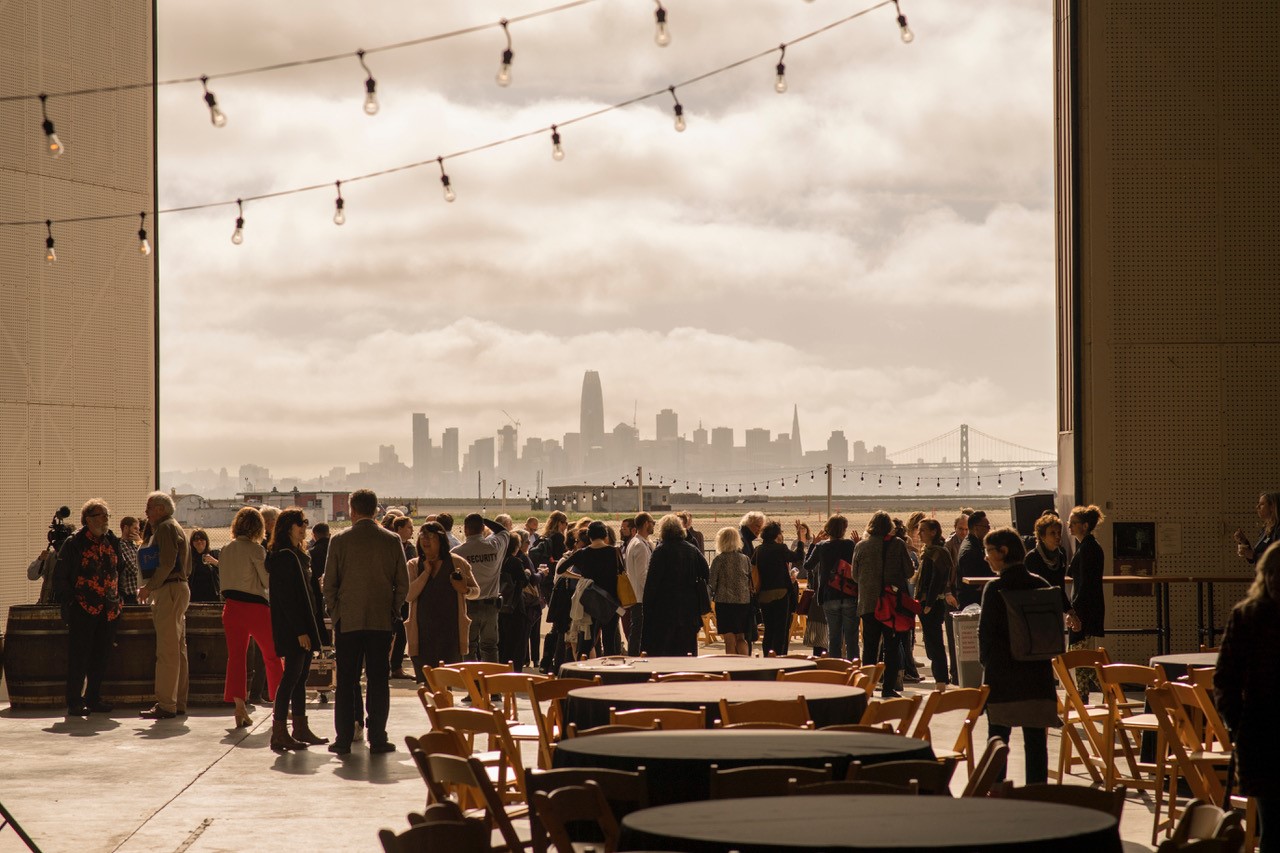
After listening to the final Resilient by Design Bay Area Challenge presentations for all the design teams, attending the closing roundtables and speeches, and reading the June 2018 special issue of ESTUARY News focused on resilience planning, the Bay’s top environmental history writer John Hart reflects on take-homes. He welcomes your own feedback below.
In the heyday of Bay fill, in the early 1960s, a University of California planning professor named Jack Kent had a modest proposal: could not the cities that were busily building out into the tidelands at least get together to agree on a future final shoreline?
Half a century later, we are looking at nine plans of a very different sort, each promising to adapt a piece of the Bay margin to a world of higher tides, rising groundwater, and more frequent flooding from streams. At least six of the plans center also on disadvantaged communities now occupying those threatened littorals: the Canal district of San Rafael; Marin City north of the Golden Gate; San Francisco’s Bayview; South San Francisco; East Palo Alto; East Oakland; and North Richmond.
Listening to the presentations at the May 18 Resilient Bay Summit, I was alert, like Kent, to possible conflicts among them. There were none. For one thing, the proposals do not adjoin; for another, these planners are too smart to push ideas that would obviously harm the neighbors. There is scarcely a seawall in the bunch. “Horizontal levees,” oyster reefs, widened flood plains, and marsh restorations abound. If, by some magic, every proposal were realized tomorrow, we would surely be in a better place than we are today.
Of course, like all good challenges, the Resilient by Design Challenge raises a flock of questions.
Resilient Bay Summit, May 2018, Photo by Karl Nielsen
CAN EVERY INHABITED PLACE BE PROTECTED? It was a basic tenet of the competition: planners must focus on “keeping communities in place and vibrant.” These plans deliver. The poor neighborhoods now further threatened by climate change will transform but, if these visions come to pass, not a one will be lost. Key facilities will be protected and key roads elevated. Housing and businesses will be rearranged to cluster on raised ground, or, in several plans, on floating pads. The housing stock will be protected and expanded yet gentrification will be simultaneously avoided. The stark possibility that some areas will simply become uninhabitable in time goes barely acknowledged. One planner I button-holed admitted, “Many of these solutions may only work for fifty years.”
WILL THERE BE ENOUGH MUD? Along with the upward creep in sea level predictions, we’re coming to grips with the shortage of silt and sand. Are rivers and creeks bringing down enough sediment to build all these additional marshes and living levees? The Public Sediment team, in its plan for lower Alameda Creek, seeks to capture more of the grit coming down that stream for the adjacent baylands, reducing the need for dredging in the channel itself. Something similar needs to be done on every Bay tributary. But even perfect harvest of stream sediments may not be enough. The team working on the South Bay Sponge offers the idea of a Soil Swap in which not only sediment but upland earth will be moved about, building a flood-safe elevation here, scooping a tidal basin there. There would be a corresponding Land Use Swap, a transfer of development rights on a vast scale, concentrating structures on the safest ground.
WILL THERE BE ENOUGH MONEY? Disasters always unlock funding; paying for prevention is the hard thing. None of these plans come with price tags, but several teams pointed hopefully to planned expenditures that could be repurposed. The South Bay Sponge, for example, could use some of the billions now slated for Army Corps levee projects that would be trimmed. At San Rafael, Marcel Wilson of Bionic team observed, most of the buildings will be replaced in the next fifty years anyway; it’s a matter of organizing to do it right. At the end of the Resilient Bay Summit, the Bay Area Council stepped up to promise $10 million in private funds for California adaptation projects by September, vital seed money indeed. Yet, any way you figure it, the coming tab looks huge.
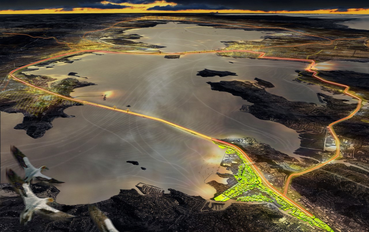
Connectivity vision of a resilient bay as rendered by the RbD Bionic team working to adapt San Rafael to sea level rise. Art: Bionic
CAN COMMUNITIES MOBILIZE FAST ENOUGH? We heard it again and again: to make good things happen, the neighborhoods themselves must both grasp the new threat and develop the power to influence solutions. Each Resilient by Design planning team found its own ingenious method of reaching, informing, and gathering ideas from local people.
Yet — because community groups were brought in late and got a small slice of the total funding—the reception was sometimes cool. A notable exception was Marin City, where the community approached the planning group Permaculture + Social Equity, not the other way around. The plans (relatively small in scale here) took shape in the context of an eight-week permaculture or eco-literacy workshop that also focused on advocacy skills. But this bootstrapping process is in a race with time.
CAN OUR GOVERNMENTS RISE TO THE NEED? Perhaps most fundamentally, these plans demand that we develop new organizational muscles. This challenge seems least daunting where a project lies within the purview of one or two local governments. This is the case in the Canal, in Marin City, in North Richmond, and in the Islais Creek basin in San Francisco. In South San Francisco, the Resilient South City proposal can feed directly into an upcoming revision of the local General Plan. In other instances, numerous cities and sometimes several counties are involved. And always there hovers overhead a swarm of regulatory agencies, each regional in scope but each devoted to a narrow purpose or zone, intervening like Olympic deities in the planning struggles below.
Take the case of the Estuary Commons plan, centered on San Leandro Bay but covering parts of Oakland, San Leandro, and Alameda. To make this vision real, each city has to rethink its traditional plans and also its traditional habit of going it alone. As Alameda mayor Trish Spence remarked, “We’re still in the middle of updating our golf course, as in spending millions of dollars. And go look at the plan. Our golf course, underwater!” The Oakland Airport, BART, CalTrans, the Coliseum Authority, and sundry regional bodies must also be on board with any program like this.
A second sort of institutional void often gapes at the bottom, not the top: a lack of neighborhood-level bodies to define and speak for community needs.
To overcome such obstacles, the plans posit a number of new government mechanisms: Community Benefit Districts, Joint Powers Agreements, and a South Bay Mutual Benefit Resiliency District. (A little known tool is the Geologic Hazard Abatement District, which under state law has extraordinary powers.) Even in the Islais basin, entirely within San Francisco, a JPA might be required among City departments! But all such arrangements have the effect of further complicating what one juror called “the jurisdictional cornucopia” of the region.
Indeed, government, or “governance,” was a recurrent theme. Who, in the end, will make these projects go, prioritize funding, screen for conflicts, fill in the spaces among these promising plans, make sure that disadvantaged communities don’t lose out again in the quest for solutions? A region-wide, authoritative blueprint for threatened shorelines seems a necessity, but can anyone create such a thing? The Bay Conservation and Development Commission comes to mind, but BCDC, the product of an earlier planning revolution, has no interest in fomenting a second one.
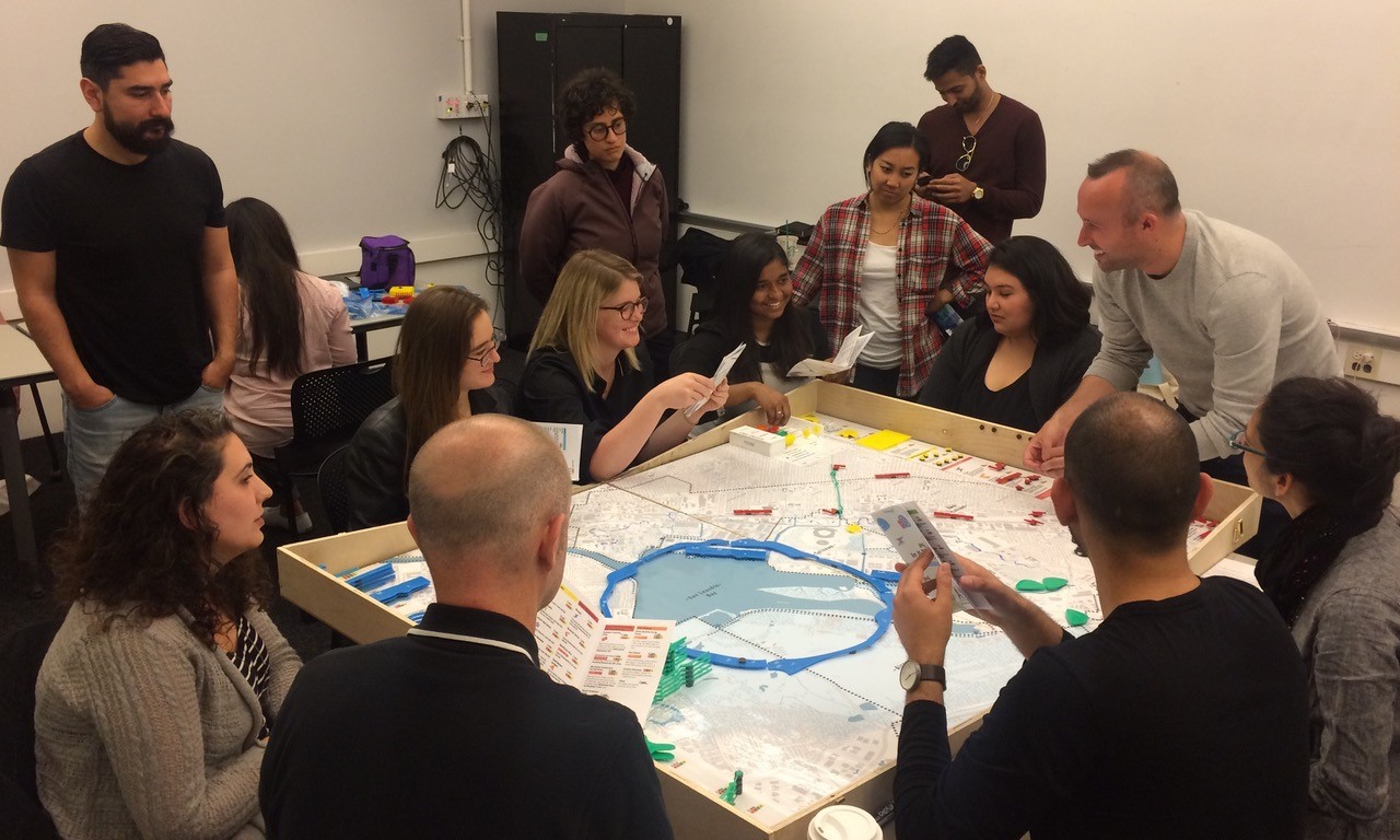
Communities role play decision-making about how to adapt to sea level rise with In It Together game developed by California College of the Arts as part of the All Bay Collective RbD team. Photo: Janette Kim.
Collaboration is the word of the day. In the noble attempt to think and work together, ever-new groupings, task forces, councils are formed. The Bay Area’s alphabet soup of agencies and entities gets thicker. Pity the poor citizen trying to keep track of it all! In most cases, however, the existing power relationships are sacrosanct.
In a new Regulatory Integration Team, we are assured, “No agency gives up any authority.” The new BayCAN, “a network of networks,” has the slogan: “By local government, for local government.” It’s a double message: everything must change, yet no one will be made uncomfortable.
We must hope but also wonder: can a “network of networks” really do what must be done?
Despite perennial resistance, the facts keep nudging the region toward some less fuzzy form of centralization. The latest candidate for a guiding role is the Metropolitan Transportation Commission, which is building upon its real if indirect power as the arbiter of regional road and transit funding. Not perhaps the ideal vehicle, if the pun may be excused; but it is the vehicle we seem to have.
Near the end of the Resilient Bay Summit, the current chair of the commission, Jake Mackenzie of Rohnert Park, offered a stark, unscripted, assessment: “[We] are going to require a degree of regional cooperation that has not existed up until now. …Unless we get some form of logical regional government, you are going to be a long time waiting for these visions to be realized.”
John Hart is an environmental journalist and author of sixteen books and several hundred other published works. He is also the winner of the James D. Phelan Award, the Commonwealth Club Medal in Californiana, and the David R. Brower Award for Service in the Field of Conservation. For ESTUARY, he writes on groundwater, infrastructure, and California water politics and history.
Our magazine’s media motto for many years has been “Where there’s an estuary, there’s a crowd.” The San Francisco Estuary is a place where people, wildlife, and commerce congregate, and where watersheds, rivers and the ocean meet and mix, creating a place of unusual diversity. In choosing to tell the...
Ever since the state and federal water projects were built in the 1930s and 1940s, California has captured snowmelt in foothill reservoirs, and moved the fresh water from dam releases and river outflows to parched parts of the state via aqueducts hundreds of miles long. A convoluted system of ancient...
Though the Clean Water Act did an amazing job of reducing wastewater and stormwater pollution of the San Francisco Estuary, some contaminants remain thorny problems. Legacy pollutants like mercury washed into the watershed from upstream gold mining, PCBs from old industrial sites, and selenium from agricultural drainage in the San...
Hothouse Earth
By Ariel Rubissow Okamoto
Photo by Megan Nguyen
Nothing could be stranger than sitting in the dark with thousands of suits and heels, watching a parade of promises to decarbonize from companies and countries large and small, reeling from the beauties of big screen rainforests and indigenous necklaces, and getting all choked up.
It was day two of the September 2018 Global Climate Action Summit in San Francisco when I felt it.
At first I wondered if I was simply starstruck. Most of us labor away trying to fix one small corner of the planet or another without seeing the likes of Harrison Ford, Al Gore, Michael Bloomberg, Van Jones, Jerry Brown – or the ministers or mayors of dozens of cities and countries – in person, on stage and at times angry enough to spit. And between these luminaries a steady stream of CEOs, corporate sustainability officers, and pension fund managers promising percentages of renewables and profits in their portfolios dedicated to the climate cause by 2020-2050.
I tried to give every speaker my full attention: the young man of Vuntut Gwichin heritage from the edge of the Yukon’s Arctic National Wildlife Refuge who pleaded with us not to enter his sacred lands with our drills and dependencies; all the women – swathed in bright patterns and head-scarfs – who kept punching their hearts. “My uncle in Uganda would take 129 years to emit the same amount of carbon as an American would in one year,” said Oxfam’s Winnie Byanyima.
“Our janitors are shutting off the lights you leave on,” said Aida Cardenas, speaking about the frontline workers she trains, mostly immigrants, who are excited to be part of climate change solutions in their new country.
The men on the stage, strutting about in feathers and pinstripes, spoke of hopes and dreams, money and power. “The notion that you can either do good or do well is a myth we have to collectively bust,” said New Jersey Governor Phil Murphy whose state is investing heavily in offshore wind farms.
“Climate change isn’t just about risks, it’s about opportunities,” said Blackrock sustainable investment manager Brian Deese.
But it wasn’t all these fine speeches that started the butterflies. Halfway through the second day of testimonials, it was a slight white-haired woman wrapped in an azure pashmina that pricked my tears. One minute she was on the silver screen with Alec Baldwin and the next she taking a seat on stage. She talked about trees. How trees can solve 30% of our carbon reduction problem. How we have to stop whacking them back in the Amazon and start planting them everywhere else. I couldn’t help thinking of Dr. Seuss and his truffala trees. Jane Goodall, over 80, is as fierce as my Lorax. Or my daughter’s Avatar.
Analyzing my take home feeling from the event I realized it wasn’t the usual fear – killer storms, tidal waves, no food for my kids to eat on a half-baked planet – nor a newfound sense of hope – I’ve always thought nature will get along just fine without us. What I felt was relief. People were actually doing something. Doing a lot. And there was so much more we could do.
As we all pumped fists in the dark, as the presentations went on and on and on because so many people and businesses and countries wanted to STEP UP, I realized how swayed I had let myself be by the doomsday news mill.
“We must be like the river, “ said a boy from Bangladesh named Risalat Khan, who had noticed our Sierra watersheds from the plane. “We must cut through the mountain of obstacles. Let’s be the river!”
Or as Harrison Ford less poetically put it: “Let’s turn off our phones and roll up our sleeves and kick this monster’s ass.”
4th California Climate Change Assessment Blues
by Isaac Pearlman
Since California’s last state-led climate change assessment in 2012, the Golden State has experienced a litany of natural disasters. This includes four years of severe drought from 2012 to 2016, an almost non-existent Sierra Nevada snowpack in 2014-2015 costing $2.1 billion in economic losses, widespread Bay Area flooding from winter 2017 storms, and extremely large and damaging wildfires culminating with this year’s Mendocino Complex fire achieving the dubious distinction of the largest in state history. California’s most recent climate assessment, released August 27th, predicts that for the state and the Bay Area, we can expect even more in the future.
The California state government first began assessing climate impacts formally in 2006, due to an executive order by Governor Schwarzenegger. California’s latest iteration and its fourth overall, includes a dizzying array of 44 technical reports; three topical studies on climate justice, tribal and indigenous communities, and the coast and ocean; as well as nine region-specific analyses.
The results are alarming for our state’s future: an estimated four to five feet of sea level rise and loss of one to two-thirds of Southern California beaches by 2100, a 50 percent increase in wildfires over 25,000 acres, stronger and longer heat waves, and infrastructure like airports, wastewater treatment plants, rail and roadways increasingly likely to suffer flooding.
For the first time, California’s latest assessment dives into climate consequences on a regional level. Academics representing nine California regions spearheaded research and summarized the best available science on the variable heat, rain, flooding and extreme event consequences for their areas. For example, the highest local rate of sea level rise in the state is at the rapidly subsiding Humboldt Bay. In San Diego county, the most biodiverse in all of California, preserving its many fragile and endangered species is an urgent priority. Francesca Hopkins from UC Riverside found that the highest rate of childhood asthma in the state isn’t an urban smog-filled city but in the Imperial Valley, where toxic dust from Salton Sea disaster chokes communities – and will only become worse as higher temperatures and less water due to climate change dry and brittle the area.
According to the Bay Area Regional Report, since 1950 the Bay Area has already increased in temperature by 1.7 degrees Fahrenheit and local sea level is eight inches higher than it was one hundred years ago. Future climate will render the Bay Area less suitable for our evergreen redwood and fir forests, and more favorable for tolerant chaparral shrub land. The region’s seven million people and $750 billion economy (almost one-third of California’s total) is predicted to be increasingly beset by more “boom and bust” irregular wet and very dry years, punctuated by increasingly intense and damaging storms.
Unsurprisingly, according to the report the Bay Area’s intensifying housing and equity problems have a multiplier affect with climate change. As Bay Area housing spreads further north, south, and inland the result is higher transportation and energy needs for those with the fewest resources available to afford them; and acute disparity in climate vulnerability across Bay Area communities and populations.
“All Californians will likely endure more illness and be at greater risk of early death because of climate change,” bluntly states the statewide summary brochure for California’s climate assessment. “[However] vulnerable populations that already experience the greatest adverse health impacts will be disproportionately affected.”
“We’re much better at being reactive to a disaster than planning ahead,” said UC Berkeley professor and contributing author David Ackerly at a California Adaptation Forum panel in Sacramento on August 27th. “And it is vulnerable communities that suffer from those disasters. How much human suffering has to happen before it triggers the next round of activity?”
The assessment’s data is publicly available online at “Cal-adapt,” where Californians can explore projected impacts for their neighborhoods, towns, and regions.


 The results are alarming for our state’s future: an estimated four to five feet of sea level rise and loss of one to two-thirds of Southern California beaches by 2100, a 50 percent increase in wildfires over 25,000 acres, stronger and longer heat waves, and infrastructure like airports, wastewater treatment plants, rail and roadways increasingly likely to suffer flooding.