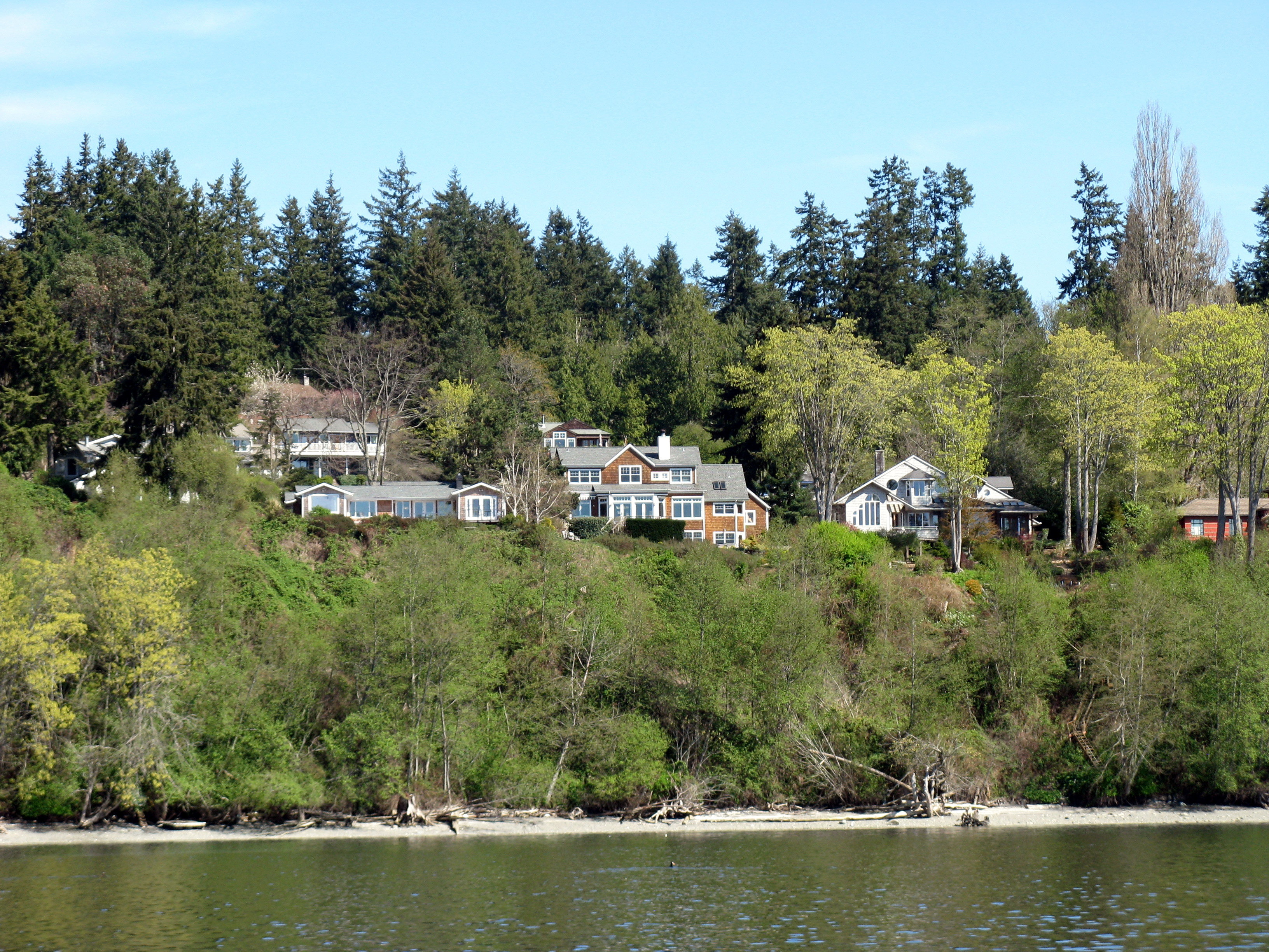
Typical shoreline on the Puget Sound, Washington, where many private properties descend steeply right to the beach. Photo courtesy Hugh Shipman.
For two cold clear days in February, scientists, engineers, and other specialists from all three North American coasts gathered at the Oakland Airport Hilton, in what a local speaker called “the least interesting part of Oakland,” for the second national Living Shorelines Technology Transfer Workshop. The event, co-sponsored by Restore America’s Estuaries, the California Coastal Conservancy, and Save the Bay, featured talks and interactive sessions on this emerging approach to coastal protection that went well beyond technology. Referred to by some practitioners as “soft shorelines” or “green shorelines,” living shorelines projects deploy a range of environmentally friendly alternatives to armoring shores against rising seas and stronger storm surges, along a gray-to-green continuum.
As speakers described challenges encountered and progress made from the San Juan Islands to North Carolina’s New River estuary, distinct regional flavors emerged. “We all live in unique systems,” Hugh Shipman of the Washington State Department of Ecology noted. East and Gulf Coast living shorelines projects have been hailed as models, but their lessons may not translate to the Pacific Coast, where significant regional differences also surfaced. San Francisco Bay and Puget Sound, the coast’s two great urbanized estuaries, have much in common—hipster scenes, high-tech fortunes, coffee cults, earthquake anxiety—but, as Shipman and two other Washington State panelists made clear, they diverge in the opportunities and constraints they present for living shoreline initiatives.
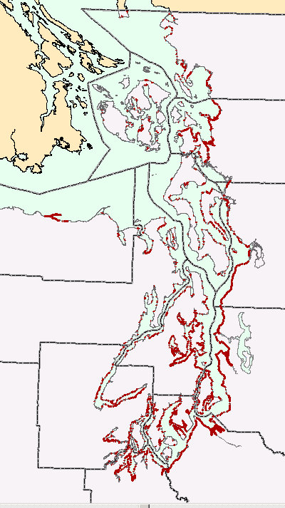
Puget Sound, a glacial fjord system, with coastal armor shown in red.
For one thing, Puget Sound, unlike San Francisco Bay, is a glacial fjord system. Its waters are deep, its shores mostly steep and its beaches narrow, with some river delta marshland on the east side. The tidal amplitude is greater and wave energy is higher. Sediment moves around mainly within the system rather than down from an interior watershed. Coarse sediment and large pieces of wood are key components. Aquatic vegetation is different; cordgrass, for example, is absent.
Armoring this shoreline has had a suite of impacts such the loss of upper beach habitat, reduction in sediment supply, and disruption of continuity between marine and upland forest ecosystems. “Shoreline erosion is an important ecosystem process, driving ecological functions,” Shipman explained. Promoted by state and local regulations, the goal of what Washingtonians prefer to call soft shorelines is to reduce erosion while maintaining those functions. The state’s administrative code requires property owners to demonstrate that soft approaches won’t work before permitting hard options.
“There’s no single template, but a tool box,” Shipman said. Small-scale beach nourishment has been the most commonly used tool. Backshore (not beach) planting and the structural use of large wood are also part of the repertoire, with multiple techniques and hybrid designs in play. Supported by federal and state funding, some beaches have been restored by removing hardened erosion control structures.
Shipman acknowledged mixed results: “Some projects have worked very poorly. Some haven’t dealt with underlying causes of erosion like the sediment deficit.” He also points to “a dearth of good contractor and designer experience” and a lack of long-term study and follow-up: “There’s been more monitoring done than evaluation and synthesis.”
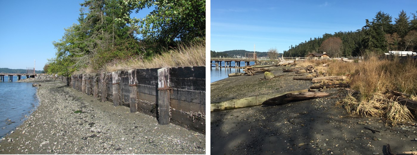
Before and after shorelines. Creosote timber bulkhead removed at Cornet Bay in Deception Pass State Park, Puget Sound. Photos: Hugh Shipman
Limited confidence in the soft shore approach among property owners remains a constraint. However, other projects have performed well in the short run. “We’re all thinking about how sea level rise will change the world enormously,” Shipman said. “Our projects are going to look different. Long-term resilience needs space and sediment.”
Almost a third of Puget Sound’s 2,500 miles of shoreline is already armored; living shorelines advocates want to keep that proportion from increasing.
That means getting buy-in from shoreline landowners. According to Nicole Faghin of Washington Sea Grant, half of the sound’s shoreline properties are the sites of single-family homes, whose owners are anxious to protect their beaches and may be dubious about novel approaches.
“Homeowners are concerned about erosion and the cost of having to do something, and terrified of the permit process,” she said, summarizing survey results. Faghin sees social marketing as a way of making this target audience more receptive to living shorelines, with “Shore Friendly” branding, LEED-inspired certification programs, and “homeowner ambassadors” for peer-to-peer credibility. That also goes for key influencers like contractors, who can be offered specialty certification and preferred provider lists, and realtors, who may respond to continuing education credits. Streamlined permitting is part of the incentive mix.
Puget Sound also has shoreline communities with no exact Bay Area parallel. Todd Woodard described his beach restoration work with the Samish Indian Nation’s Department of Natural Resources, whose Samish name translates as “House of Watching Over All the Territory.” “There’s a deep cultural connection to the sea,” Woodard said. “There’s a Samish saying: ‘When the tide is out, the table is set.’ It’s impossible to distinguish cultural from natural resources.”
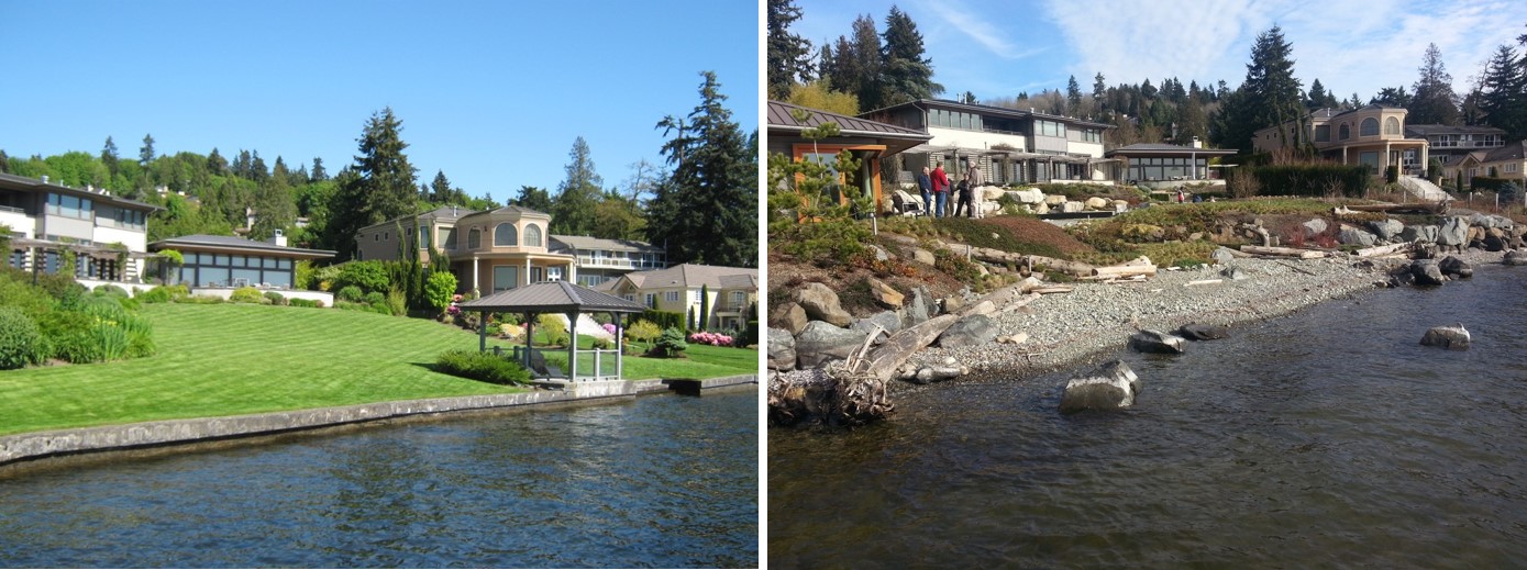
Lawns on Lake Washington in Kirkland replaced with softer shoreline. Photos: Watershed Company (before) Nicole Faghin (after)
Woodward’s projects with the Samish at Weaverling Spit near Anacortes have addressed the recovery of shellfish and forage fish habitat and access for annual canoe festivals as well as winter storm effects. He’s consulted traditional ecological knowledge to inform shoreline planting: “We’ve talked to local folks about how their culture used plants, tried to look outside the landscapers’ standard menu.” Local nurseries have been propagating culturally important native plants for restoration projects.
Katharyn Boyer of San Francisco State University’s Estuary & Ocean Science Center, with deep experience in intertidal habitat restoration, sees differences on both policy and operational levels between Puget Sound and the Bay. Unlike Washington and some Gulf and East Coast states, California has no state or regional policy requirement for living shorelines to be considered before implementing harder alternatives.
Local projects have done less with coarse sediment and woody material, but that may be changing. Pilot projects at San Francisco’s Pier 94 and Aramburu Island in Richardson Bay have already used coarse sediment. Aramburu also incorporates wooden groins. “There are other places where woody material would work, with placement and degree of anchoring dependent on the direction of the waves hitting the shore,” says Boyer. Properly placed, it would help promote sediment accumulation. The San Francisco Estuary Institute is involved in developing operational guidelines. She also notes that unlike San Francisco Bay, Washington is not looking at vegetation to protect shorelines.
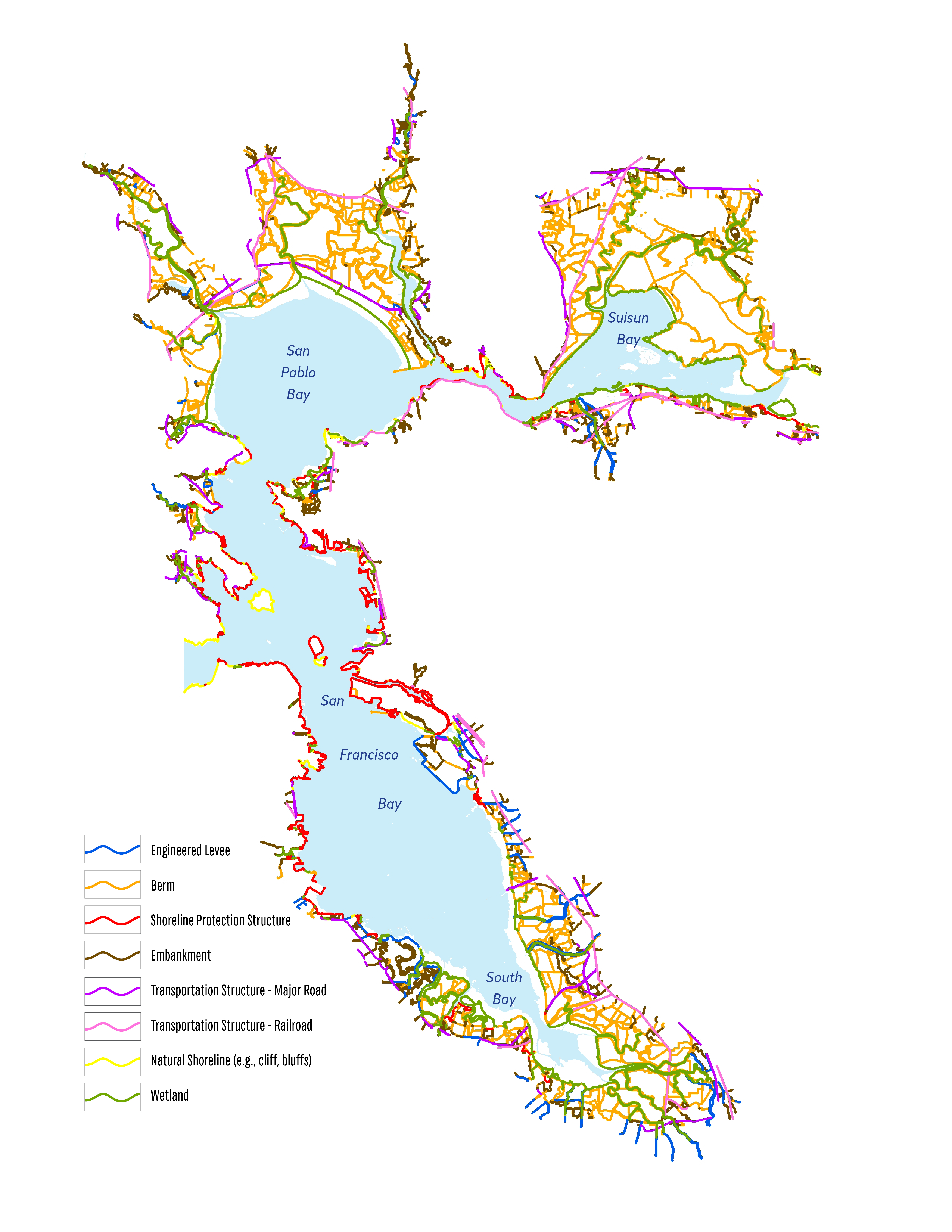
San Francisco Bay has an enormous amount of public land and infrastructure such as ports, roads, railroads, and airports, right on the shore. Map: Shore Inventory, SFEI, 2016
Ownership of shoreline land and subtidal acreage is another consideration. “Coordination here may be easier with larger parcels and fewer owners,” Boyers says, contrasting Puget Sound’s many private shoreline properties with the huge stretches of Bayshore in the East Bay Regional Park system. A complication in San Francisco Bay is the pattern of private ownership of subtidal parcels. “It’s not necessarily the same landowners as at the shore’s edge,” she adds—a mosaic of corporate, nonprofit, and individually owned lands. “Marin County Open Space owns parcels out in the middle of Corte Madera Bay.” Boyer’s oyster-reef project off San Rafael is sited on a Nature Conservancy parcel; expanding it would run up against private ownership.
Events like the Oakland workshop, with additional sessions addressing outreach, funding, permitting, and other areas, foster the exchange of ideas and techniques among regions. Boyer says it has already inspired further discussion with folks in Washington State: “There’s more we can learn from them.”
Joe Eaton writes about endangered and invasive species, climate and ecosystem science, environmental history, and water issues for ESTUARY. He is also "a semi-obsessive birder" whose pursuit of rarities has taken him to many of California's shores, wetlands, and sewage plants.
Our magazine’s media motto for many years has been “Where there’s an estuary, there’s a crowd.” The San Francisco Estuary is a place where people, wildlife, and commerce congregate, and where watersheds, rivers and the ocean meet and mix, creating a place of unusual diversity. In choosing to tell the...
Ever since the state and federal water projects were built in the 1930s and 1940s, California has captured snowmelt in foothill reservoirs, and moved the fresh water from dam releases and river outflows to parched parts of the state via aqueducts hundreds of miles long. A convoluted system of ancient...
Though the Clean Water Act did an amazing job of reducing wastewater and stormwater pollution of the San Francisco Estuary, some contaminants remain thorny problems. Legacy pollutants like mercury washed into the watershed from upstream gold mining, PCBs from old industrial sites, and selenium from agricultural drainage in the San...
Hothouse Earth
By Ariel Rubissow Okamoto
Photo by Megan Nguyen
Nothing could be stranger than sitting in the dark with thousands of suits and heels, watching a parade of promises to decarbonize from companies and countries large and small, reeling from the beauties of big screen rainforests and indigenous necklaces, and getting all choked up.
It was day two of the September 2018 Global Climate Action Summit in San Francisco when I felt it.
At first I wondered if I was simply starstruck. Most of us labor away trying to fix one small corner of the planet or another without seeing the likes of Harrison Ford, Al Gore, Michael Bloomberg, Van Jones, Jerry Brown – or the ministers or mayors of dozens of cities and countries – in person, on stage and at times angry enough to spit. And between these luminaries a steady stream of CEOs, corporate sustainability officers, and pension fund managers promising percentages of renewables and profits in their portfolios dedicated to the climate cause by 2020-2050.
I tried to give every speaker my full attention: the young man of Vuntut Gwichin heritage from the edge of the Yukon’s Arctic National Wildlife Refuge who pleaded with us not to enter his sacred lands with our drills and dependencies; all the women – swathed in bright patterns and head-scarfs – who kept punching their hearts. “My uncle in Uganda would take 129 years to emit the same amount of carbon as an American would in one year,” said Oxfam’s Winnie Byanyima.
“Our janitors are shutting off the lights you leave on,” said Aida Cardenas, speaking about the frontline workers she trains, mostly immigrants, who are excited to be part of climate change solutions in their new country.
The men on the stage, strutting about in feathers and pinstripes, spoke of hopes and dreams, money and power. “The notion that you can either do good or do well is a myth we have to collectively bust,” said New Jersey Governor Phil Murphy whose state is investing heavily in offshore wind farms.
“Climate change isn’t just about risks, it’s about opportunities,” said Blackrock sustainable investment manager Brian Deese.
But it wasn’t all these fine speeches that started the butterflies. Halfway through the second day of testimonials, it was a slight white-haired woman wrapped in an azure pashmina that pricked my tears. One minute she was on the silver screen with Alec Baldwin and the next she taking a seat on stage. She talked about trees. How trees can solve 30% of our carbon reduction problem. How we have to stop whacking them back in the Amazon and start planting them everywhere else. I couldn’t help thinking of Dr. Seuss and his truffala trees. Jane Goodall, over 80, is as fierce as my Lorax. Or my daughter’s Avatar.
Analyzing my take home feeling from the event I realized it wasn’t the usual fear – killer storms, tidal waves, no food for my kids to eat on a half-baked planet – nor a newfound sense of hope – I’ve always thought nature will get along just fine without us. What I felt was relief. People were actually doing something. Doing a lot. And there was so much more we could do.
As we all pumped fists in the dark, as the presentations went on and on and on because so many people and businesses and countries wanted to STEP UP, I realized how swayed I had let myself be by the doomsday news mill.
“We must be like the river, “ said a boy from Bangladesh named Risalat Khan, who had noticed our Sierra watersheds from the plane. “We must cut through the mountain of obstacles. Let’s be the river!”
Or as Harrison Ford less poetically put it: “Let’s turn off our phones and roll up our sleeves and kick this monster’s ass.”
4th California Climate Change Assessment Blues
by Isaac Pearlman
Since California’s last state-led climate change assessment in 2012, the Golden State has experienced a litany of natural disasters. This includes four years of severe drought from 2012 to 2016, an almost non-existent Sierra Nevada snowpack in 2014-2015 costing $2.1 billion in economic losses, widespread Bay Area flooding from winter 2017 storms, and extremely large and damaging wildfires culminating with this year’s Mendocino Complex fire achieving the dubious distinction of the largest in state history. California’s most recent climate assessment, released August 27th, predicts that for the state and the Bay Area, we can expect even more in the future.
The California state government first began assessing climate impacts formally in 2006, due to an executive order by Governor Schwarzenegger. California’s latest iteration and its fourth overall, includes a dizzying array of 44 technical reports; three topical studies on climate justice, tribal and indigenous communities, and the coast and ocean; as well as nine region-specific analyses.
The results are alarming for our state’s future: an estimated four to five feet of sea level rise and loss of one to two-thirds of Southern California beaches by 2100, a 50 percent increase in wildfires over 25,000 acres, stronger and longer heat waves, and infrastructure like airports, wastewater treatment plants, rail and roadways increasingly likely to suffer flooding.
For the first time, California’s latest assessment dives into climate consequences on a regional level. Academics representing nine California regions spearheaded research and summarized the best available science on the variable heat, rain, flooding and extreme event consequences for their areas. For example, the highest local rate of sea level rise in the state is at the rapidly subsiding Humboldt Bay. In San Diego county, the most biodiverse in all of California, preserving its many fragile and endangered species is an urgent priority. Francesca Hopkins from UC Riverside found that the highest rate of childhood asthma in the state isn’t an urban smog-filled city but in the Imperial Valley, where toxic dust from Salton Sea disaster chokes communities – and will only become worse as higher temperatures and less water due to climate change dry and brittle the area.
According to the Bay Area Regional Report, since 1950 the Bay Area has already increased in temperature by 1.7 degrees Fahrenheit and local sea level is eight inches higher than it was one hundred years ago. Future climate will render the Bay Area less suitable for our evergreen redwood and fir forests, and more favorable for tolerant chaparral shrub land. The region’s seven million people and $750 billion economy (almost one-third of California’s total) is predicted to be increasingly beset by more “boom and bust” irregular wet and very dry years, punctuated by increasingly intense and damaging storms.
Unsurprisingly, according to the report the Bay Area’s intensifying housing and equity problems have a multiplier affect with climate change. As Bay Area housing spreads further north, south, and inland the result is higher transportation and energy needs for those with the fewest resources available to afford them; and acute disparity in climate vulnerability across Bay Area communities and populations.
“All Californians will likely endure more illness and be at greater risk of early death because of climate change,” bluntly states the statewide summary brochure for California’s climate assessment. “[However] vulnerable populations that already experience the greatest adverse health impacts will be disproportionately affected.”
“We’re much better at being reactive to a disaster than planning ahead,” said UC Berkeley professor and contributing author David Ackerly at a California Adaptation Forum panel in Sacramento on August 27th. “And it is vulnerable communities that suffer from those disasters. How much human suffering has to happen before it triggers the next round of activity?”
The assessment’s data is publicly available online at “Cal-adapt,” where Californians can explore projected impacts for their neighborhoods, towns, and regions.


 The results are alarming for our state’s future: an estimated four to five feet of sea level rise and loss of one to two-thirds of Southern California beaches by 2100, a 50 percent increase in wildfires over 25,000 acres, stronger and longer heat waves, and infrastructure like airports, wastewater treatment plants, rail and roadways increasingly likely to suffer flooding.
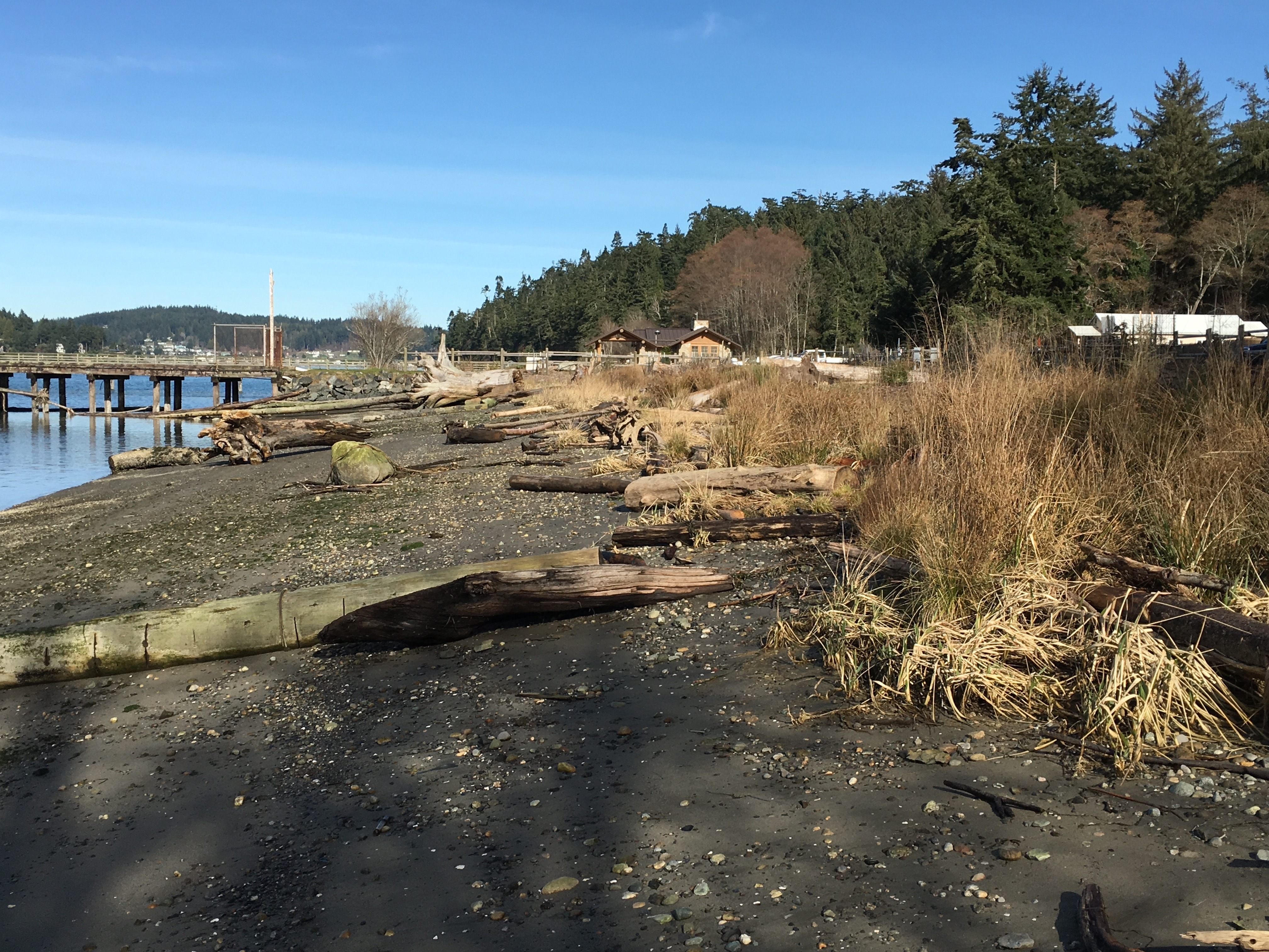