After decades of restoration, recent Chinook salmon runs in Putah Creek have reached 1,800, producing young that swim toward the ocean by the tens of thousands. But, says Putah Creek streamkeeper Max Stevenson, this growing population still faces considerable obstacles.
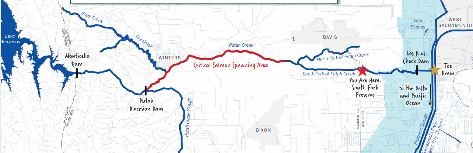
Putah Creek flows from headwaters in the North Coast Ranges to the Toe Drain of the Yolo Bypass, and was dammed near Winters in the 1950s to divert water for Solano County. Salmon began coming to the creek after settlement of a lawsuit in the year 2000 that stipulated releasing water for fish as well as optimizing spawning grounds.
Salmon need loose gravel to dig spawning pits, or redds, that are up to six feet across. “They flop over and slap cobbles as big as six inches with the side of their body,” says Stevenson, who the Solano County Water Agency hired almost exactly a year ago as streamkeeper to protect and restore Putah Creek. After spawning, salmon fill the pits back up with gravel to hide their bright-orange eggs from predators.
Dams keep new gravel from tumbling down Putah Creek, and old gravel hardens over time as the space between cobbles fills with fine sediment, forming a thick, cement-like crust on the creek bed. “You can walk on it and not sink in,” Stevenson says. To loosen the gravel for salmon, the restoration team “fluffs it up with excavators.”
Last year, the team also tried something new. They added 80 tons of gravel below the pedestrian bridge in Winters and were almost immediately rewarded. “There were 15 redds!” Stevenson says. Salmon can lay thousands of eggs in a redd.
Spawning grounds are not enough to support a self-sustaining population of salmon, however. These migratory fish also need unrestricted passage. “You can create gold-star, top of the line, Cadillac salmon habitat but it doesn’t matter if they can’t get there,” Stevenson says. “There’s wonderful upstream habitat near Winters, but below I-80 hasn’t seen the love yet.”
Map: City of Davis
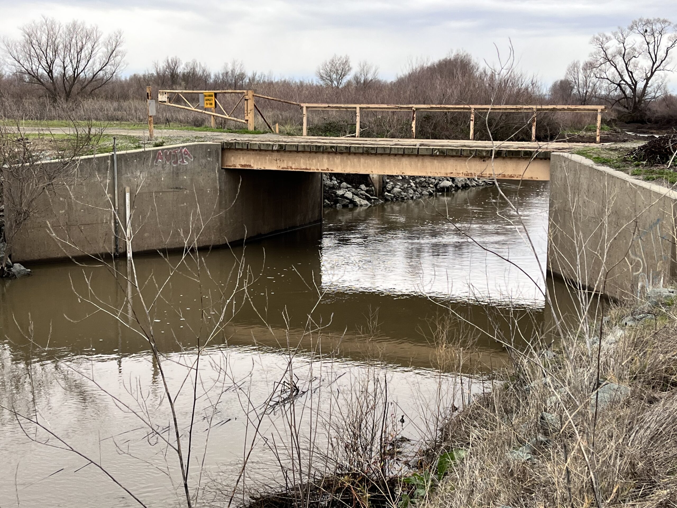
The lower reaches of Putah Creek between I-80 and the Toe Drain are like an obstacle course, sporting several barriers to fish migration. One barrier, a pair of culverts under County Road 106a, has a temporary fix. “The culverts are way too high for salmon to jump,” Stevenson says. So the restoration team worked with the farmer who owns the land to install a new fish-friendly culvert.
Stevenson is excited that they used culvert design software, called FishXing, to optimize the size and placement of the new pipe for salmon. From a fish point of view, culverts are trouble when they are out of reach or when water comes through too fast to swim against. The restoration crew embedded the bottom of the new, but temporary, culvert in the stream bed, both making it accessible and slowing the water.
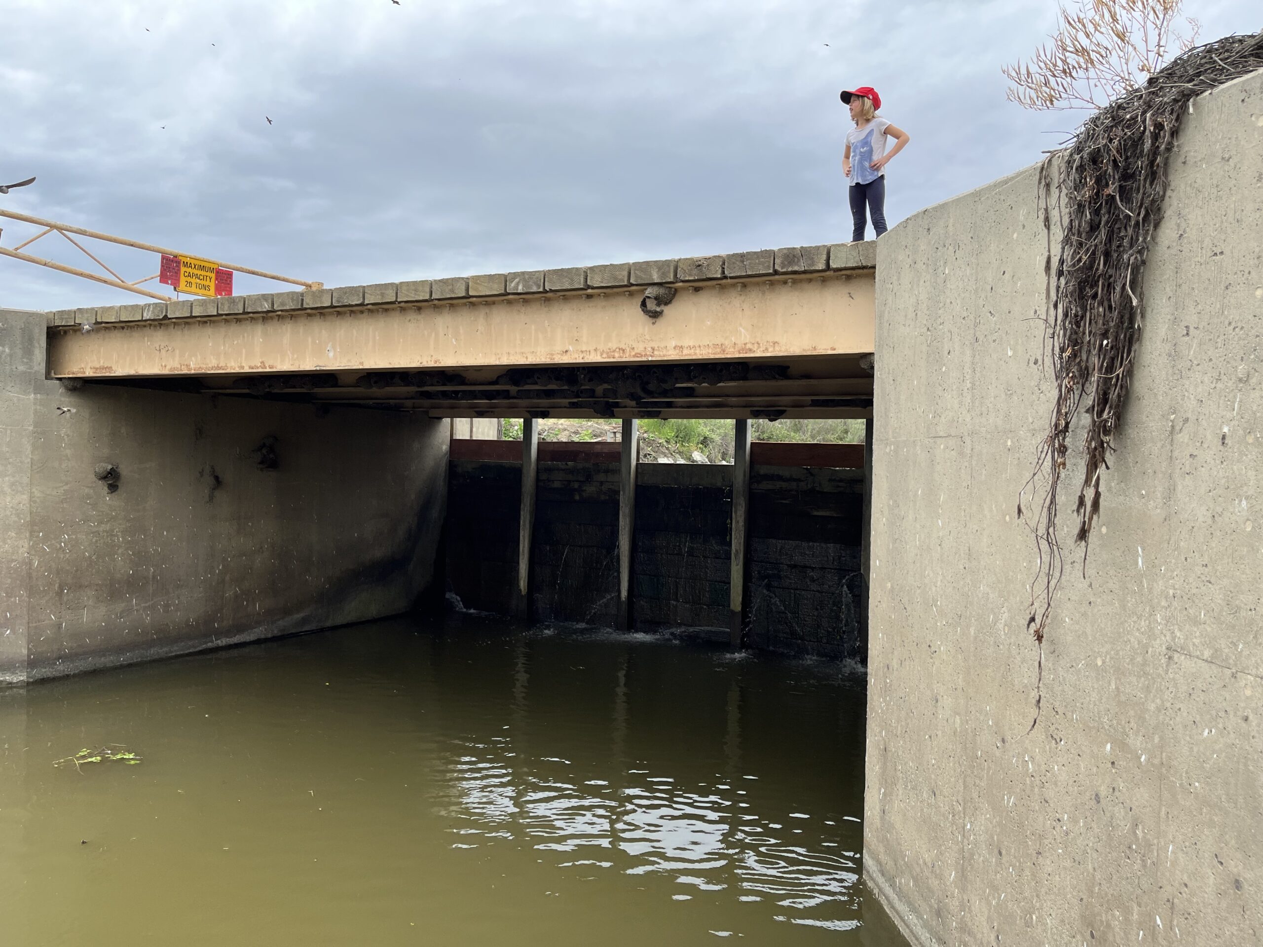
Two miles downstream of Road 106a lies another, more significant barrier to fish passage. This is the Los Rios Check Dam, which is more than 12 feet high and is opened and closed by manually removing and replacing heavy wooden boards. “As soon as the check dam was opened in November last year, 64 salmon shot through the new Road 106a culvert in two hours,” Stevenson says. The fish-friendly culvert is something of a bandaid, though, because it could get washed out in the next storm.
Check dam with manual barriers. Photo: Max Stevenson
For a permanent solution to both barriers, Stevenson envisions creating bypasses to allow year-round fish passage. A 1,600-foot channel around the check dam and a small bridge-like creek crossing for Road 106a would each cost less than $1 million. Stevenson also hopes for a solution to a third salmon barrier: the Lisbon Weir, which is made of rocks and spans the 100-foot width of the Toe Drain.
Stevenson’s big dream is to realign Putah Creek below I-80 completely. “The lower third is human-made,” he says. “It was dug out in the 1870s to relieve flooding and is as straight as an arrow.” Realignment would sidestep all three fish barriers at a cost of $20 to $40 million.
While the restoration team collaborates with many of the private landowners along the creek, sometimes it just doesn’t work out. “Landowners worry about ATV trespassing and equipment theft in the park-like areas created by restoration,” Stevenson says. “They don’t always want to invite that.”
Plans for rerouting lower Putah Creek have been drawn up. The beauty is that the bypasses to Lisbon Weir, the Los Rios Check Dam, and Road 106a would all be built entirely on public land, which would simplify the process.
“The ten miles near Winters are great for salmon,” Stevenson says. “But these fish have to swim another 100 miles between Putah Creek and the ocean—we need to connect them.”
Top Image: Los Rios Check Dam open for fish passage. Photo: Max Stevenson
Robin Meadows is an independent science journalist in the San Francisco Bay Area. She’s a water reporter at Maven's Notebook, a California water news site, and contributor to Chemical & Engineering News, Ka Pili Kai, KneeDeep Times, and Scientific American. Robin is also a Pulitzer Center grantee, an Institute for Journalism & Natural Resources fellow, a contributor to The Craft of Science Writing, a mentor with The Open Notebook, and a UC Santa Cruz Science Communication Program graduate. Find her on Tumblr and Twitter.
Our magazine’s media motto for many years has been “Where there’s an estuary, there’s a crowd.” The San Francisco Estuary is a place where people, wildlife, and commerce congregate, and where watersheds, rivers and the ocean meet and mix, creating a place of unusual diversity. In choosing to tell the...
Ever since the state and federal water projects were built in the 1930s and 1940s, California has captured snowmelt in foothill reservoirs, and moved the fresh water from dam releases and river outflows to parched parts of the state via aqueducts hundreds of miles long. A convoluted system of ancient...
Though the Clean Water Act did an amazing job of reducing wastewater and stormwater pollution of the San Francisco Estuary, some contaminants remain thorny problems. Legacy pollutants like mercury washed into the watershed from upstream gold mining, PCBs from old industrial sites, and selenium from agricultural drainage in the San...
Hothouse Earth
By Ariel Rubissow Okamoto
Photo by Megan Nguyen
Nothing could be stranger than sitting in the dark with thousands of suits and heels, watching a parade of promises to decarbonize from companies and countries large and small, reeling from the beauties of big screen rainforests and indigenous necklaces, and getting all choked up.
It was day two of the September 2018 Global Climate Action Summit in San Francisco when I felt it.
At first I wondered if I was simply starstruck. Most of us labor away trying to fix one small corner of the planet or another without seeing the likes of Harrison Ford, Al Gore, Michael Bloomberg, Van Jones, Jerry Brown – or the ministers or mayors of dozens of cities and countries – in person, on stage and at times angry enough to spit. And between these luminaries a steady stream of CEOs, corporate sustainability officers, and pension fund managers promising percentages of renewables and profits in their portfolios dedicated to the climate cause by 2020-2050.
I tried to give every speaker my full attention: the young man of Vuntut Gwichin heritage from the edge of the Yukon’s Arctic National Wildlife Refuge who pleaded with us not to enter his sacred lands with our drills and dependencies; all the women – swathed in bright patterns and head-scarfs – who kept punching their hearts. “My uncle in Uganda would take 129 years to emit the same amount of carbon as an American would in one year,” said Oxfam’s Winnie Byanyima.
“Our janitors are shutting off the lights you leave on,” said Aida Cardenas, speaking about the frontline workers she trains, mostly immigrants, who are excited to be part of climate change solutions in their new country.
The men on the stage, strutting about in feathers and pinstripes, spoke of hopes and dreams, money and power. “The notion that you can either do good or do well is a myth we have to collectively bust,” said New Jersey Governor Phil Murphy whose state is investing heavily in offshore wind farms.
“Climate change isn’t just about risks, it’s about opportunities,” said Blackrock sustainable investment manager Brian Deese.
But it wasn’t all these fine speeches that started the butterflies. Halfway through the second day of testimonials, it was a slight white-haired woman wrapped in an azure pashmina that pricked my tears. One minute she was on the silver screen with Alec Baldwin and the next she taking a seat on stage. She talked about trees. How trees can solve 30% of our carbon reduction problem. How we have to stop whacking them back in the Amazon and start planting them everywhere else. I couldn’t help thinking of Dr. Seuss and his truffala trees. Jane Goodall, over 80, is as fierce as my Lorax. Or my daughter’s Avatar.
Analyzing my take home feeling from the event I realized it wasn’t the usual fear – killer storms, tidal waves, no food for my kids to eat on a half-baked planet – nor a newfound sense of hope – I’ve always thought nature will get along just fine without us. What I felt was relief. People were actually doing something. Doing a lot. And there was so much more we could do.
As we all pumped fists in the dark, as the presentations went on and on and on because so many people and businesses and countries wanted to STEP UP, I realized how swayed I had let myself be by the doomsday news mill.
“We must be like the river, “ said a boy from Bangladesh named Risalat Khan, who had noticed our Sierra watersheds from the plane. “We must cut through the mountain of obstacles. Let’s be the river!”
Or as Harrison Ford less poetically put it: “Let’s turn off our phones and roll up our sleeves and kick this monster’s ass.”
4th California Climate Change Assessment Blues
by Isaac Pearlman
Since California’s last state-led climate change assessment in 2012, the Golden State has experienced a litany of natural disasters. This includes four years of severe drought from 2012 to 2016, an almost non-existent Sierra Nevada snowpack in 2014-2015 costing $2.1 billion in economic losses, widespread Bay Area flooding from winter 2017 storms, and extremely large and damaging wildfires culminating with this year’s Mendocino Complex fire achieving the dubious distinction of the largest in state history. California’s most recent climate assessment, released August 27th, predicts that for the state and the Bay Area, we can expect even more in the future.
The California state government first began assessing climate impacts formally in 2006, due to an executive order by Governor Schwarzenegger. California’s latest iteration and its fourth overall, includes a dizzying array of 44 technical reports; three topical studies on climate justice, tribal and indigenous communities, and the coast and ocean; as well as nine region-specific analyses.
The results are alarming for our state’s future: an estimated four to five feet of sea level rise and loss of one to two-thirds of Southern California beaches by 2100, a 50 percent increase in wildfires over 25,000 acres, stronger and longer heat waves, and infrastructure like airports, wastewater treatment plants, rail and roadways increasingly likely to suffer flooding.
For the first time, California’s latest assessment dives into climate consequences on a regional level. Academics representing nine California regions spearheaded research and summarized the best available science on the variable heat, rain, flooding and extreme event consequences for their areas. For example, the highest local rate of sea level rise in the state is at the rapidly subsiding Humboldt Bay. In San Diego county, the most biodiverse in all of California, preserving its many fragile and endangered species is an urgent priority. Francesca Hopkins from UC Riverside found that the highest rate of childhood asthma in the state isn’t an urban smog-filled city but in the Imperial Valley, where toxic dust from Salton Sea disaster chokes communities – and will only become worse as higher temperatures and less water due to climate change dry and brittle the area.
According to the Bay Area Regional Report, since 1950 the Bay Area has already increased in temperature by 1.7 degrees Fahrenheit and local sea level is eight inches higher than it was one hundred years ago. Future climate will render the Bay Area less suitable for our evergreen redwood and fir forests, and more favorable for tolerant chaparral shrub land. The region’s seven million people and $750 billion economy (almost one-third of California’s total) is predicted to be increasingly beset by more “boom and bust” irregular wet and very dry years, punctuated by increasingly intense and damaging storms.
Unsurprisingly, according to the report the Bay Area’s intensifying housing and equity problems have a multiplier affect with climate change. As Bay Area housing spreads further north, south, and inland the result is higher transportation and energy needs for those with the fewest resources available to afford them; and acute disparity in climate vulnerability across Bay Area communities and populations.
“All Californians will likely endure more illness and be at greater risk of early death because of climate change,” bluntly states the statewide summary brochure for California’s climate assessment. “[However] vulnerable populations that already experience the greatest adverse health impacts will be disproportionately affected.”
“We’re much better at being reactive to a disaster than planning ahead,” said UC Berkeley professor and contributing author David Ackerly at a California Adaptation Forum panel in Sacramento on August 27th. “And it is vulnerable communities that suffer from those disasters. How much human suffering has to happen before it triggers the next round of activity?”
The assessment’s data is publicly available online at “Cal-adapt,” where Californians can explore projected impacts for their neighborhoods, towns, and regions.


 The results are alarming for our state’s future: an estimated four to five feet of sea level rise and loss of one to two-thirds of Southern California beaches by 2100, a 50 percent increase in wildfires over 25,000 acres, stronger and longer heat waves, and infrastructure like airports, wastewater treatment plants, rail and roadways increasingly likely to suffer flooding.