When the storm hit, it was lucky that my parents had a habit of leaving one car on each side of the Carmel River as they commuted from Big Sur into Monterey each day. The 1995 El Niño rainfall had pushed the Carmel River into hundreds of homes, and destroyed the Highway 1 bridge that connected Big Sur with the rest of the world. Most Big Sur residents were trapped during the week it took the Federal Emergency Management Agency (FEMA) to repair the freeway bridge.
But in the era before Zoom, my mother couldn’t just stay home from nursing school. So my parents trekked past the mud of submerged artichoke fields on the river’s south bank and onto the flooded Rancho Cañada golf course, where my dad was “surprised as hell” to find an intact wood-slatted suspension bridge. They crossed it with the river seething around their ankles, then backtracked past the flooded homes and parking lots on the north bank to where my mom’s old blue pickup truck was waiting safely just above the floodwaters to carry them to school and work.
The Carmel River of the late 20th century was a tale of California water extremes writ small. In 1998 it flooded homes again, but in most years, the river was largely reduced to a trickle as it was siphoned off to water the blooming tourist mecca of the Monterey Peninsula. Endangered steelhead trout, members of the southernmost surviving population, would often find their attempts to swim upriver and spawn thwarted by strandings in low water before they could even reach the impassable dams upstream. The national advocacy group American Rivers even included the Carmel on its infamous “Most Endangered Rivers” list in 1999.
But in the last decade, the river has staged a surging comeback, with a high-profile dam removal in 2015 presaging a new wave of restoration about to break ground. The river’s degraded floodplain is now poised for a transformation born of decades of advocacy—just in time, many hope, to turn the fortunes of the fish, frogs, and people who are threatened by the river’s status quo.
Life After Dam
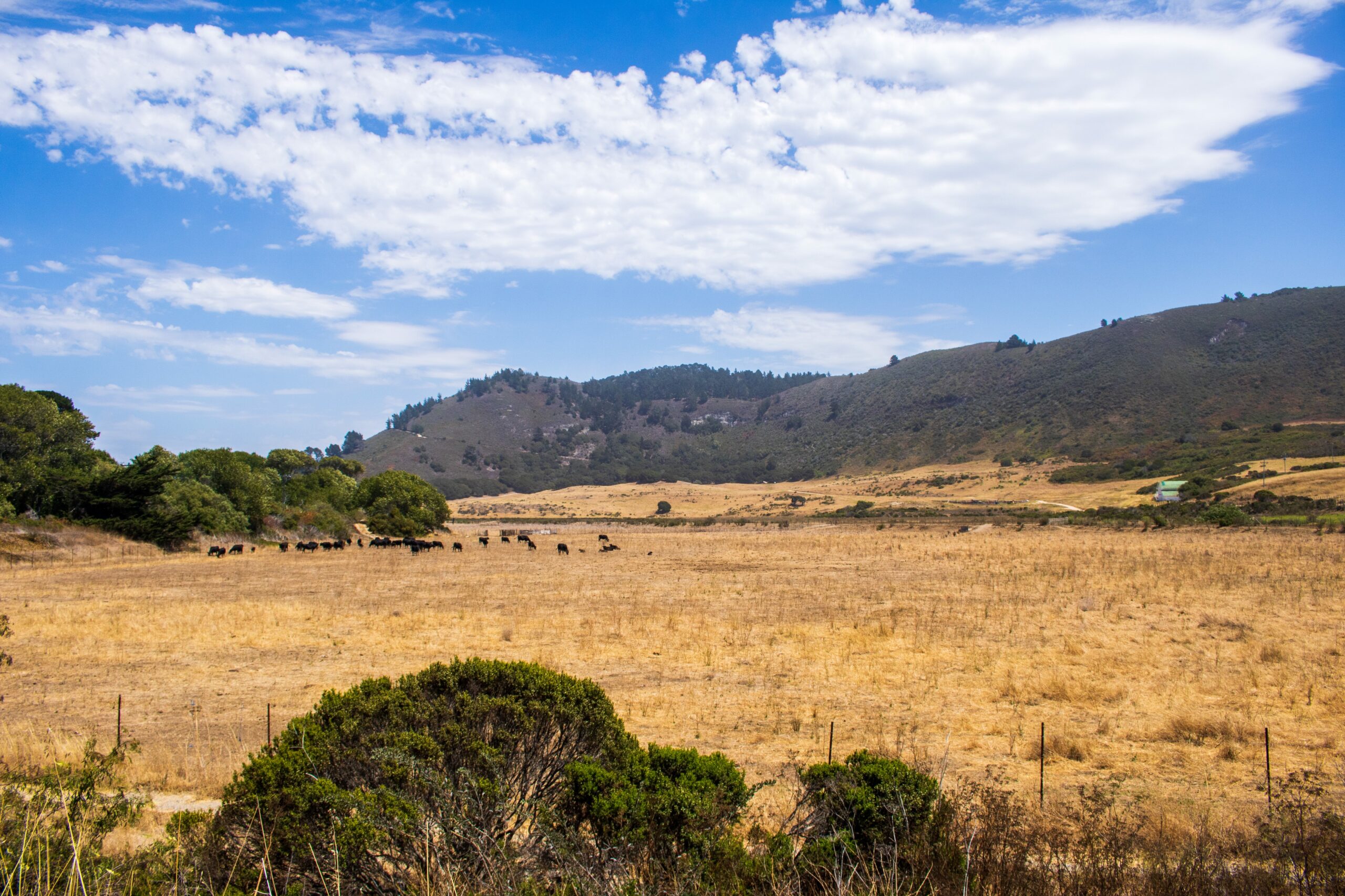
On a breezy July afternoon, I retraced my parents’ path upriver from Highway One along the southern edge of the Carmel River floodplain. The artichoke fields my parents slogged through decades ago had long since given way to a flat, sun-baked pasture dotted with grazing cattle, with only a distant line of trees hinting at where the sunken river flows beneath the freeway bridge that replaced the one it destroyed in 1995. Just on the other side of the freeway, where the river flows into the Carmel River Lagoon, I could see a slice of white beach where the lagoon meets the sea. Several leaders of the Carmel River Floodplain Restoration and Environmental Enhancement project (CR-FREE) walked alongside me.
“The river will once again be connected to the floodplain, and the floodplain will be connected to the lagoon in a way that hasn’t happened since the levees were built,” Rachel Saunders explained as we gazed across the yellow landscape toward Carmel River Beach. Saunders is director of conservation at the Big Sur Land Trust, one of the core members of what she describes as the “Rubik’s cube” of groups enmeshed in the decades of planning for the CR-FREE project.
So far in the 21st century, the river’s biggest claim to fame has undoubtedly been the 2015 toppling of the San Clemente Dam, the largest dam-removal project ever completed in California. Saunders describes the ambitious floodplain plans now in motion as a “bookend” to that event, with the restoration leaving as monumental a mark on the river’s fate as destruction of the century-old dam.
Today, the hundreds of people who have invested time, money, and expertise into returning the floodplain to some semblance of its original self fall into two camps: those working on the CR-FREE site, which abuts the freeway where the surging river once washed the bridge seaward, and those involved in a separate, more recent, project on county-park property just upstream called Rancho Cañada. Both projects boast similar aims: restoring floodplain habitat for threatened species like steelhead while diminishing future flood damage to homes and businesses.
The CR-FREE restoration plan hinges on punching a series of holes in the century-old levees along roughly a mile of the river’s south bank. The levees were originally built to protect the farmland on the south bank, and in most years, they accomplish that—but they have also corralled the river over time into a sunken incision, like a canyon. The holes in the levees will allow smaller channels of water to spill onto the floodplain when the river fills.
The broad vision of reshaping the lower floodplain, where the river flows seaward beneath the freeway, has existed since the catastrophic El Niño floods of the 1990s. Planning began moving “in earnest” a decade later, Saunders tells me, and by the mid-2010s, efforts to make what became known as the CR-FREE project a reality were fully underway. CalTrans had come on board for the eventual construction of a second causeway bridge under the freeway, and actor-cum-local-politician Clint Eastwood, who had acquired the old artichoke farmland decades previously and committed part of it to CR-FREE, had agreed to donate his remaining acres of that property to the project.
But decades of coming out on the losing end of local water politics was still straining the river and its denizens, especially as chronic drought gripped the state. The historic San Clemente Dam removal upstream brought hope for the river to conservation groups, and steelhead advocates in particular, but nobody expected the water windfall that was to come.
A Confluence Upstream
For decades, the Rancho Cañada golf course was one of the largest water guzzlers drawing from the river, second only to the residential and industrial users of the Monterey Peninsula. It was a plum parcel on the lip of Carmel Valley, an area known less for its eponymous river than for its tennis courts, boutique wineries, and vacationing millionaires escaping the fog of Pebble Beach. So for Christy Fischer, then the executive director of the local Santa Lucia Land Trust, it was a shock when the sprawling property went up for sale in 2016, after nearly half a century of operation.
Fischer was desperate for the land trust to acquire the parcel not only for the prospect of new public access trails, but because the alternative could have shifted the ecology of the area from bad to worse. The land going up for sale meant the water rights were for sale as well. The golf course was at least open space, and she feared that the choice location—and the water that came with it—would inevitably lead any other buyer to erect “a wall of development” beside the riverbed.
Right away, recalls Fischer, “I knew I needed to bring that price down. I couldn’t compete with five developers.”
She obtained an agreement from the Monterey Peninsula Regional Park District to eventually take over managing the parcel, and then asked property owner the Hatton family to consider accepting a more modest price, in exchange for leaving a legacy of land to the wider community. To her surprise, they agreed. The California Coastal Conservancy, California Natural Resources Agency, California Department of Fish and Wildlife, and Wildlife Conservation Board (to name just a few) all chipped in to fund the acquisition, and the golf course became public land.
“Given the [proximity] to popularized, urban areas, it’s really incredible that so many hundreds of acres are set aside,” says John Bair, a restoration ecologist with McBain Associates who consults on the Rancho Cañada restoration. “That makes it a really unusual opportunity.” (Of the nearly 200 total acres that were acquired from the former golf course and converted to public space, the floodplain at Rancho Cañada will be restored on 40 acres; the CR-FREE project will restore 100 acres of floodplain.)
Tom Gandesbery, project manager at the California Coastal Conservancy—which has invested $2 million in the Rancho Cañada restoration—agrees that holds true for both projects. “There are these two very fairly large pieces of real estate that weren’t completely paved over and turned into houses or shopping malls,” he noted. “In a lot of parts of California, you can find rivers like the Guadalupe River in Santa Clara County that goes through San Jose. The upper watershed might be intact … but when you go down to the lower watershed, where the floodplains were historically, they’ve all been developed.”
Projects for the People
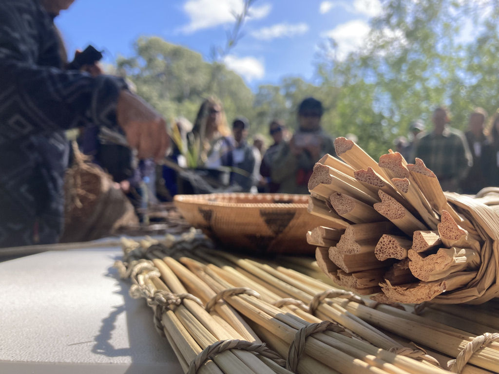
Linda Yamane says she “almost jumped out of [her] chair with excitement” when she learned that sandbar willow will be among the species planted along the restored Carmel River floodplain. The ancestors of the Rumsen Ohlone master basketweaver and tribal scholar lived along the Carmel River a mile upstream from the Rancho Canada project, and relied on tender willow shoots, earthy sedge rhizomes, and fibrous dogbane to craft everything from ceremonial baskets to jewelry and practical tools of everyday life.
“[Sandbar willow] is the one willow species with all of the attributes needed for fine basketry work—and it’s very difficult to find in this area any more,” she explained to an audience of restoration practitioners at a conference in May 2022. “The plant list could make the difference between life and death of certain local traditional native practices.”
Sandbar willow switches, center, are among the plants essential to local native cultures that will be planted along the restored Carmel River floodplain. Photo: Sierra Garcia
When Yamane’s many-greats grandmother (seven generations back) was baptized in the Rumsen Ohlone village of Tucutnut in 1773, the Carmel River would still have been densely vegetated, and a lifeblood—as it remains today—for species such as steelhead and California red-legged frogs. The river was important to native people beyond Yamane’s tribe as well, including the Esselen Tribe of Monterey County and Ohlone Costanoan Esselen Nation.
Returning culturally relevant species to the floodplain, including one that has been completely eradicated from the riverbank for at least a century, is one of many community benefits that both restoration projects hope to provide. The former golf course land is already crisscrossed with hiking paths that continue on into the Big Sur hills, and the CR-FREE project will eventually provide trail access that connects to the same network—and beneath the freeway, to the ocean. Unlike the admiring crowds that throng many scenic hikes near the Monterey coastline, the folks strolling across the old putting green are locals: dogs returning contented from long walks, pairs of gossiping friends, families with children.
But the most important project benefit in the community psyche remains flood protection. Once the CR-FREE project is finished, the county estimates that a hundred-year flood would surge through the restored floodplain two to three feet lower than it would today. The restoration will save Monterey County $14 million in levee repair costs it would otherwise need to shoulder to protect the homes and businesses along the river from catastrophic flooding; it is also likely to reduce insurance costs for some homes. Both restoration projects have received floods of support rarely bestowed on unglamorous engineering proposals, including hundreds of public comments in favor of the CR-FREE project during its environmental impact review phase. Margaret Robbins, a constituent who delivered 18 pages full of signatures in support of the project to the County in 2019, summed up the prevailing sentiment: “I can’t imagine how anyone could object to CR-FREE. Let’s get it approved and built as soon as possible.”
Timing Is Everything?
Although the San Clemente Dam existed almost 18 miles upstream of the present-day restoration sites, it offered some lessons for the floodplain project planners. After the dam was dismembered, engineers refashioned the riverbed around it with meticulous care (and millions of dollars) to create a variety of natural-looking pools that would nurture endangered steelhead traveling upstream to spawn.
The river had other ideas. The first heavy rains after the project’s completion rearranged boulders, branches, and embankments at will. This time, says Rancho Cañada project consulting hydrologist Ben Snyder, the plan is to stay hands-off after the excavation and planting and “[allow] the river to do river things.”
“Our whole approach that we’re taking to rewilding this river is really taking the shackles off … [and] helping to create a safe space for river processes,” he added. “By [removing enough earth to] lower the floodplains as much as 13 to 15 feet, we’re going to be creating these nice open spaces where this channel can meander and occupy new parts of the floodplain.”
The CR-FREE planners downstream don’t have as much leeway to let the river freely flood and meander—although they hope and expect it to do so some years, within the limits of the land currently used for cattle grazing. If the river’s primary channel under the freeway were to migrate, it could jeopardize the wastewater treatment plant that sits precariously near the lagoon where the river runs into the sea. Still, the river will have far more leeway than at any point in the last century to wander and carve new paths through the surrounding landscape.
Both the Rancho Cañada and CR-FREE projects will need years to realize their fullest benefits. The final heavy-lifting steps of the downstream CR-FREE project, constructing the second causeway bridge beneath the freeway, could be completed by 2027. But even then, it will take years for the native saplings and sedges to form the rich riparian canopy around the expanded riverbed with enough root structure to withstand stronger flood flows.
One certainty is that the floodwaters will rise again, and much higher than the ones that my parents forded in the 1990s. Based on historical modeling, a 100-year flood is overdue. But climate change’s altering of precipitation patterns may make a “100-year” flood of the last century more likely in this one. An atmospheric river in 2017 came close to overtopping the levees, Saunders points out, and climate change is stacking the odds of more extreme rain higher than past records would suggest.
“People who live on the other side still have very clear memories of what it was like on their second floors looking down at the water that filled their garages,” Saunders says. “So every year it’s a concern. We’re living on borrowed time.”
Top Image: Cattle graze at CR-FREE site. Photo: Sierra Garcia
Sierra Garcia is an interdisciplinary marine scientist and environmental writer with a focus on oceans, climate, and communities. She is Estuary's multiplatforms editor, and does outreach and planning as well as some reporting for the magazine. Her work has appeared in publications serving a wide range of audiences, including Grist, JSTOR Daily, and the Oxford Climate Review. She was proudly born and raised in Monterey County.
Our magazine’s media motto for many years has been “Where there’s an estuary, there’s a crowd.” The San Francisco Estuary is a place where people, wildlife, and commerce congregate, and where watersheds, rivers and the ocean meet and mix, creating a place of unusual diversity. In choosing to tell the...
Ever since the state and federal water projects were built in the 1930s and 1940s, California has captured snowmelt in foothill reservoirs, and moved the fresh water from dam releases and river outflows to parched parts of the state via aqueducts hundreds of miles long. A convoluted system of ancient...
Though the Clean Water Act did an amazing job of reducing wastewater and stormwater pollution of the San Francisco Estuary, some contaminants remain thorny problems. Legacy pollutants like mercury washed into the watershed from upstream gold mining, PCBs from old industrial sites, and selenium from agricultural drainage in the San...
Hothouse Earth
By Ariel Rubissow Okamoto
Photo by Megan Nguyen
Nothing could be stranger than sitting in the dark with thousands of suits and heels, watching a parade of promises to decarbonize from companies and countries large and small, reeling from the beauties of big screen rainforests and indigenous necklaces, and getting all choked up.
It was day two of the September 2018 Global Climate Action Summit in San Francisco when I felt it.
At first I wondered if I was simply starstruck. Most of us labor away trying to fix one small corner of the planet or another without seeing the likes of Harrison Ford, Al Gore, Michael Bloomberg, Van Jones, Jerry Brown – or the ministers or mayors of dozens of cities and countries – in person, on stage and at times angry enough to spit. And between these luminaries a steady stream of CEOs, corporate sustainability officers, and pension fund managers promising percentages of renewables and profits in their portfolios dedicated to the climate cause by 2020-2050.
I tried to give every speaker my full attention: the young man of Vuntut Gwichin heritage from the edge of the Yukon’s Arctic National Wildlife Refuge who pleaded with us not to enter his sacred lands with our drills and dependencies; all the women – swathed in bright patterns and head-scarfs – who kept punching their hearts. “My uncle in Uganda would take 129 years to emit the same amount of carbon as an American would in one year,” said Oxfam’s Winnie Byanyima.
“Our janitors are shutting off the lights you leave on,” said Aida Cardenas, speaking about the frontline workers she trains, mostly immigrants, who are excited to be part of climate change solutions in their new country.
The men on the stage, strutting about in feathers and pinstripes, spoke of hopes and dreams, money and power. “The notion that you can either do good or do well is a myth we have to collectively bust,” said New Jersey Governor Phil Murphy whose state is investing heavily in offshore wind farms.
“Climate change isn’t just about risks, it’s about opportunities,” said Blackrock sustainable investment manager Brian Deese.
But it wasn’t all these fine speeches that started the butterflies. Halfway through the second day of testimonials, it was a slight white-haired woman wrapped in an azure pashmina that pricked my tears. One minute she was on the silver screen with Alec Baldwin and the next she taking a seat on stage. She talked about trees. How trees can solve 30% of our carbon reduction problem. How we have to stop whacking them back in the Amazon and start planting them everywhere else. I couldn’t help thinking of Dr. Seuss and his truffala trees. Jane Goodall, over 80, is as fierce as my Lorax. Or my daughter’s Avatar.
Analyzing my take home feeling from the event I realized it wasn’t the usual fear – killer storms, tidal waves, no food for my kids to eat on a half-baked planet – nor a newfound sense of hope – I’ve always thought nature will get along just fine without us. What I felt was relief. People were actually doing something. Doing a lot. And there was so much more we could do.
As we all pumped fists in the dark, as the presentations went on and on and on because so many people and businesses and countries wanted to STEP UP, I realized how swayed I had let myself be by the doomsday news mill.
“We must be like the river, “ said a boy from Bangladesh named Risalat Khan, who had noticed our Sierra watersheds from the plane. “We must cut through the mountain of obstacles. Let’s be the river!”
Or as Harrison Ford less poetically put it: “Let’s turn off our phones and roll up our sleeves and kick this monster’s ass.”
4th California Climate Change Assessment Blues
by Isaac Pearlman
Since California’s last state-led climate change assessment in 2012, the Golden State has experienced a litany of natural disasters. This includes four years of severe drought from 2012 to 2016, an almost non-existent Sierra Nevada snowpack in 2014-2015 costing $2.1 billion in economic losses, widespread Bay Area flooding from winter 2017 storms, and extremely large and damaging wildfires culminating with this year’s Mendocino Complex fire achieving the dubious distinction of the largest in state history. California’s most recent climate assessment, released August 27th, predicts that for the state and the Bay Area, we can expect even more in the future.
The California state government first began assessing climate impacts formally in 2006, due to an executive order by Governor Schwarzenegger. California’s latest iteration and its fourth overall, includes a dizzying array of 44 technical reports; three topical studies on climate justice, tribal and indigenous communities, and the coast and ocean; as well as nine region-specific analyses.
The results are alarming for our state’s future: an estimated four to five feet of sea level rise and loss of one to two-thirds of Southern California beaches by 2100, a 50 percent increase in wildfires over 25,000 acres, stronger and longer heat waves, and infrastructure like airports, wastewater treatment plants, rail and roadways increasingly likely to suffer flooding.
For the first time, California’s latest assessment dives into climate consequences on a regional level. Academics representing nine California regions spearheaded research and summarized the best available science on the variable heat, rain, flooding and extreme event consequences for their areas. For example, the highest local rate of sea level rise in the state is at the rapidly subsiding Humboldt Bay. In San Diego county, the most biodiverse in all of California, preserving its many fragile and endangered species is an urgent priority. Francesca Hopkins from UC Riverside found that the highest rate of childhood asthma in the state isn’t an urban smog-filled city but in the Imperial Valley, where toxic dust from Salton Sea disaster chokes communities – and will only become worse as higher temperatures and less water due to climate change dry and brittle the area.
According to the Bay Area Regional Report, since 1950 the Bay Area has already increased in temperature by 1.7 degrees Fahrenheit and local sea level is eight inches higher than it was one hundred years ago. Future climate will render the Bay Area less suitable for our evergreen redwood and fir forests, and more favorable for tolerant chaparral shrub land. The region’s seven million people and $750 billion economy (almost one-third of California’s total) is predicted to be increasingly beset by more “boom and bust” irregular wet and very dry years, punctuated by increasingly intense and damaging storms.
Unsurprisingly, according to the report the Bay Area’s intensifying housing and equity problems have a multiplier affect with climate change. As Bay Area housing spreads further north, south, and inland the result is higher transportation and energy needs for those with the fewest resources available to afford them; and acute disparity in climate vulnerability across Bay Area communities and populations.
“All Californians will likely endure more illness and be at greater risk of early death because of climate change,” bluntly states the statewide summary brochure for California’s climate assessment. “[However] vulnerable populations that already experience the greatest adverse health impacts will be disproportionately affected.”
“We’re much better at being reactive to a disaster than planning ahead,” said UC Berkeley professor and contributing author David Ackerly at a California Adaptation Forum panel in Sacramento on August 27th. “And it is vulnerable communities that suffer from those disasters. How much human suffering has to happen before it triggers the next round of activity?”
The assessment’s data is publicly available online at “Cal-adapt,” where Californians can explore projected impacts for their neighborhoods, towns, and regions.


 The results are alarming for our state’s future: an estimated four to five feet of sea level rise and loss of one to two-thirds of Southern California beaches by 2100, a 50 percent increase in wildfires over 25,000 acres, stronger and longer heat waves, and infrastructure like airports, wastewater treatment plants, rail and roadways increasingly likely to suffer flooding.