Nothing reveals just how much the upper Estuary’s seesaw of tides and freshwater flows is micro-managed than prolonged drought, and the resulting fiddling with barriers, gates, and water quality standards to prevent the ocean tides and salinity from intruding too far upstream. Come summer, managers begin to talk fearfully of “losing control of the Delta” and the dreaded outcome: salt water too near the export pumps that supply tap water for millions of Californians.
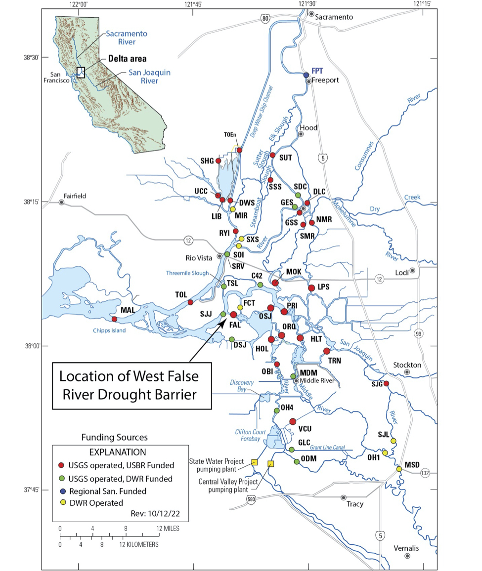
The ominous language is also reflected in the nickname of a new monitoring station at channel marker 42: “the point-of-no-return” station. Installed this August on the San Joaquin River just downstream of the Mokelumne River, the station joins a network of about 40 others at key Delta locations operated by the US Geological Survey (USGS) and the Department of Water Resources (DWR, see map). These stations send real-time data on water velocities, flow rates, salinity movements, and other water quality constituents swirling around the Delta to a computer platform every worried water manager can’t help keeping an eye on.
“It’s an early-warning location,” says USGS hydrologist Jon Burau.
Last year, water managers got dangerously close to letting the salt all the way up the San Joaquin River near the northern confluence with Old River. “Once it comes in that back door, you’re in real trouble,” says Greg Gartrell, a consulting engineer and former assistant general manager of the Contra Costa Water District at the edge of the Delta. The new monitoring station tells managers exactly what’s going on at that critical backdoor. An intensive series of workshops spearheaded by the Delta Stewardship Council is also bringing increased attention to the challenges of, and options for, salinity management.
Locations of the monitoring stations operated by the USGS and DWR, the “point-of-no-return” station (C42), and the West False River Drought Barrier. Source: USGS
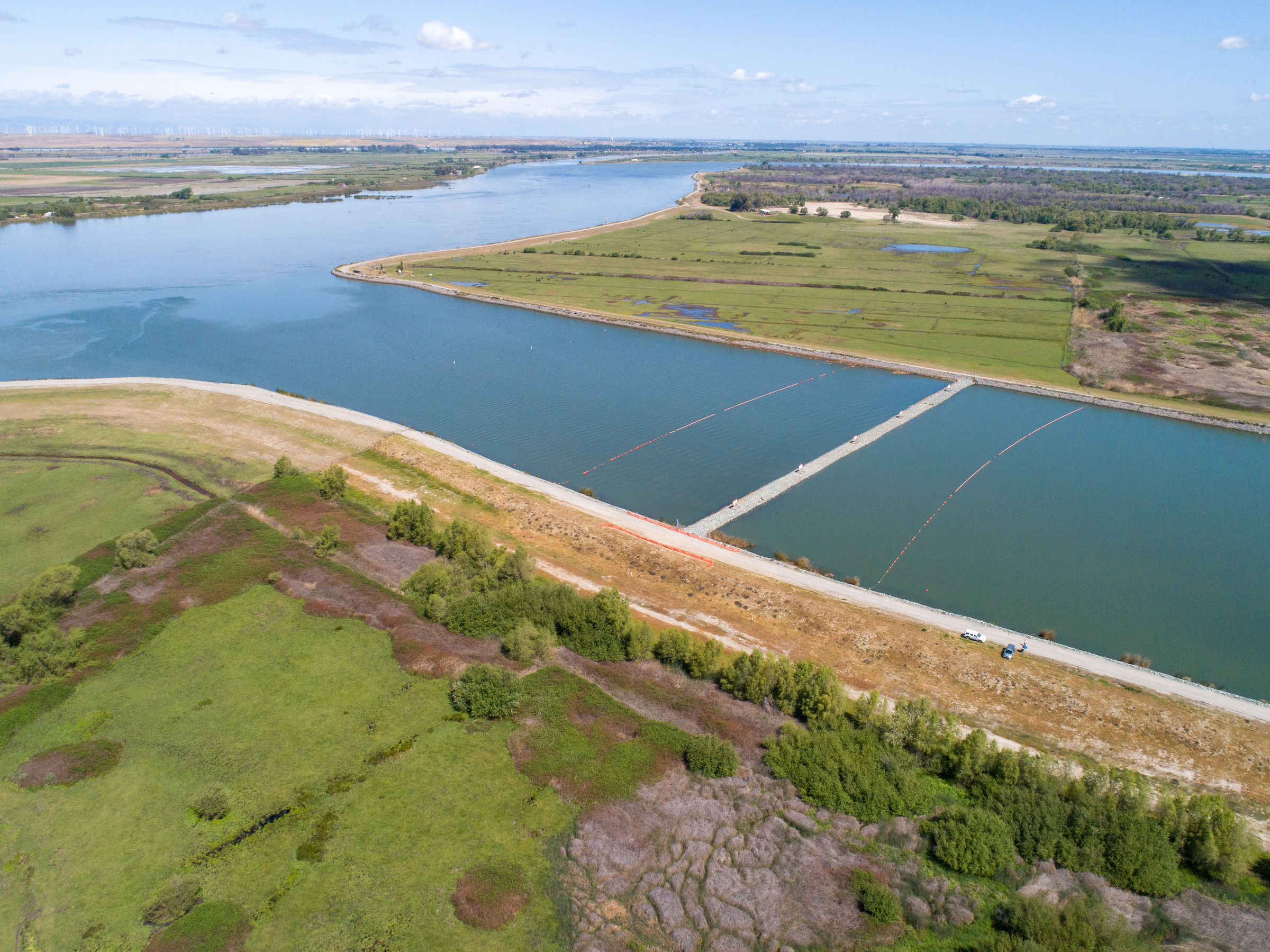
For the last few decades, the one physical thing keeping that back door shut has been a 30-foot-tall wall of rocks placed intermittently in the West False River (see map). Conditions have been so dry that this barrier has been in place since June 2021, but removal is due to start this October and finish by the end of November. The last time the Department of Water Resources placed a barrier here was in 2015.
“We’ve had these horrible, horrible dry periods that were unprecedented in the prior record,” says Gartrell, namely only four wet years from the last 20. In the past, that might have been enough wet years to get by, for water supply managers and users, but now climate change is making it much hotter and dryer, says Gartrell. “If we rely on what’s happened in the past, we’re going to get burned.”
In an Environmental Impact Report released this summer, DWR requested a permit for two more barrier placements in the next ten years. “It’s so unpredictable, and very situational, what Mother Nature is going to give us, but we need to be prepared in the event we don’t get the rain or snow we need,” says DWR engineer Jacob McQuirk.
West False River Barrier, looking northwest, near the confluence with the San Joaquin River. Photo: Florence Low, DWR
Barrier Basics & The Toolbox
Here’s a brief lesson in the purpose of the barrier for the uninitiated. Two big rivers flow through the Delta to the Bay, the Sacramento with its high-quality freshwater and reserves behind Shasta and Oroville Dams, and the San Joaquin, which has historically produced less runoff and water of poorer quality, especially as the drought persists. Water managers use several physical tools to keep the choice Sacramento River water in the central Delta flowing toward the pumps, via the so-called “freshwater corridor,” including closing and opening the giant metal gates of the Delta Cross Channel, releasing water from reservoirs to push salt water back downstream, and tapping alternate supplies like groundwater. “In severe droughts we simply don’t have the water to keep the freshwater corridor open” says Burau.
As the ocean tides push salty water further and further upstream during dry conditions, the salty water eventually reaches West False River, historically a dead-end slough but now a channel from the San Joaquin River into the vast flooded island of Franks Tract. On the other side of the tract is a dangerous opening to that mainline to the pumps, Old River.
False River is where DWR occasionally builds a physical rock barrier to plug this pathway for saltwater intrusion, avoiding water supply Armageddon: “losing the Delta.” If the drought gets worse, they may also add smaller barriers in Steamboat and Sutter Sloughs, which helps redirect additional Sacramento River water into the Central Delta.
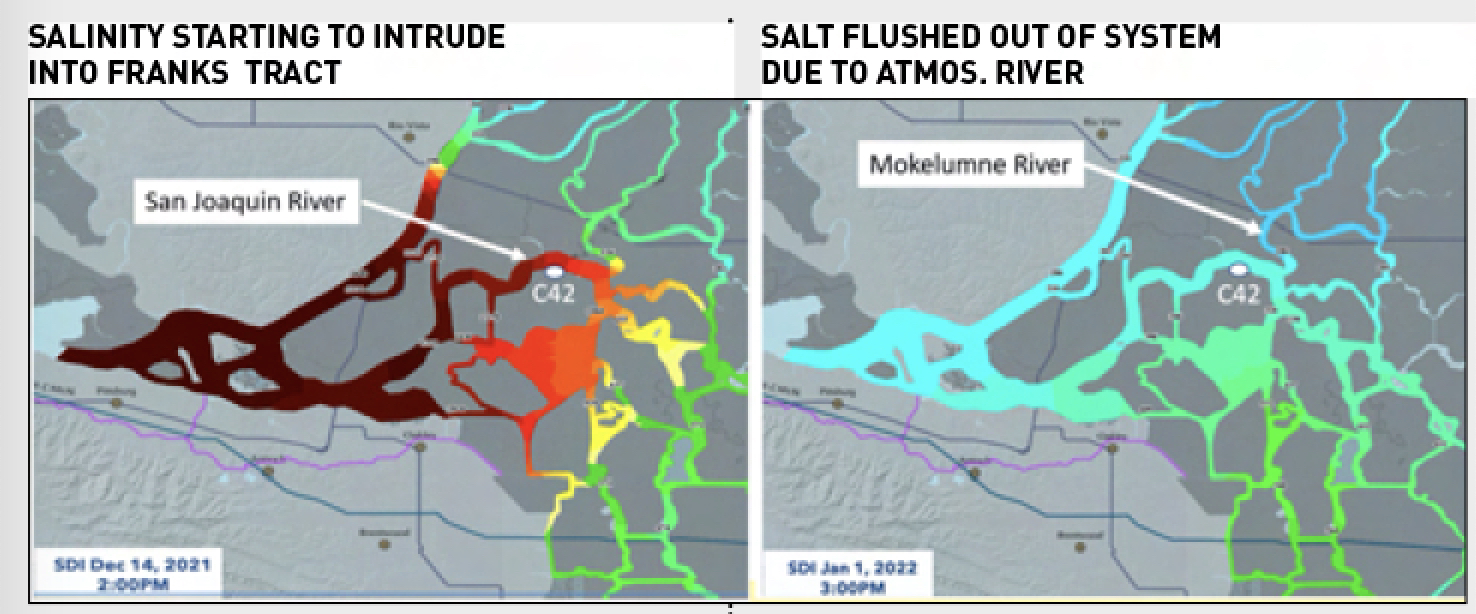
Heat maps of the Central Delta salt field in on December 14, 2021 and January 1, 2022. Image at left shows salinity intrusion at the Delta’s backdoor and the Channel Marker 42 station – the point of no return just downstream of the Mokelumne/San Joaquin River confluence. Images: Bay Delta Live
“If you push water out of one area it pops out somewhere else,” says Gartrell, which complicates salinity management.
Beyond the physical controls, there are policies that protect the various beneficial uses of Delta waters: fish habitat, water supply, agriculture, recreation, and the like. Many standards are pegged to salinity levels and specific time periods: For example, an agricultural standard requires water to be fresh enough for irrigation until the end of the growing season (August 15), while the estuarine habitat standard (also known as X2) requires the salt/fresh mixing zone to be in a specific place in the western delta between February and June, when young fish benefit from it most. Each year, and especially during drought, managers juggle all these standards, as well as various approved reasons for relaxation, such as temporary urgency change petitions (TUCPs) from DWR. A variety of federal and state pumping permits also come into play.
“Things are a lot better than they were in 2015; we’re learning to coordinate the barrier and flow management to save the most fresh water,” says DWR engineer Eli Ateljevich.
According to Gartrell, the barrier saved the state about 400,000 acre-feet of water in 2021, water that would have had to be used to push salinity downstream, if the pile of rocks weren’t sitting in False River.
One thing that’s important to remember about rocks, says McQuirk, is that they are quick and easy to use in an emergency. A more permanent fix would take much more cash and many more regulatory approvals. This past year’s barrier cost less than the 2015 version because of some competitive bidding around sourcing the rock. The final choice was a stockpile on the Stockton riverfront, also staged to be readily available for a variety of emergency uses, from breaches due to quakes and floods to future barriers.
Fish Loss, HABs and other Side Effects
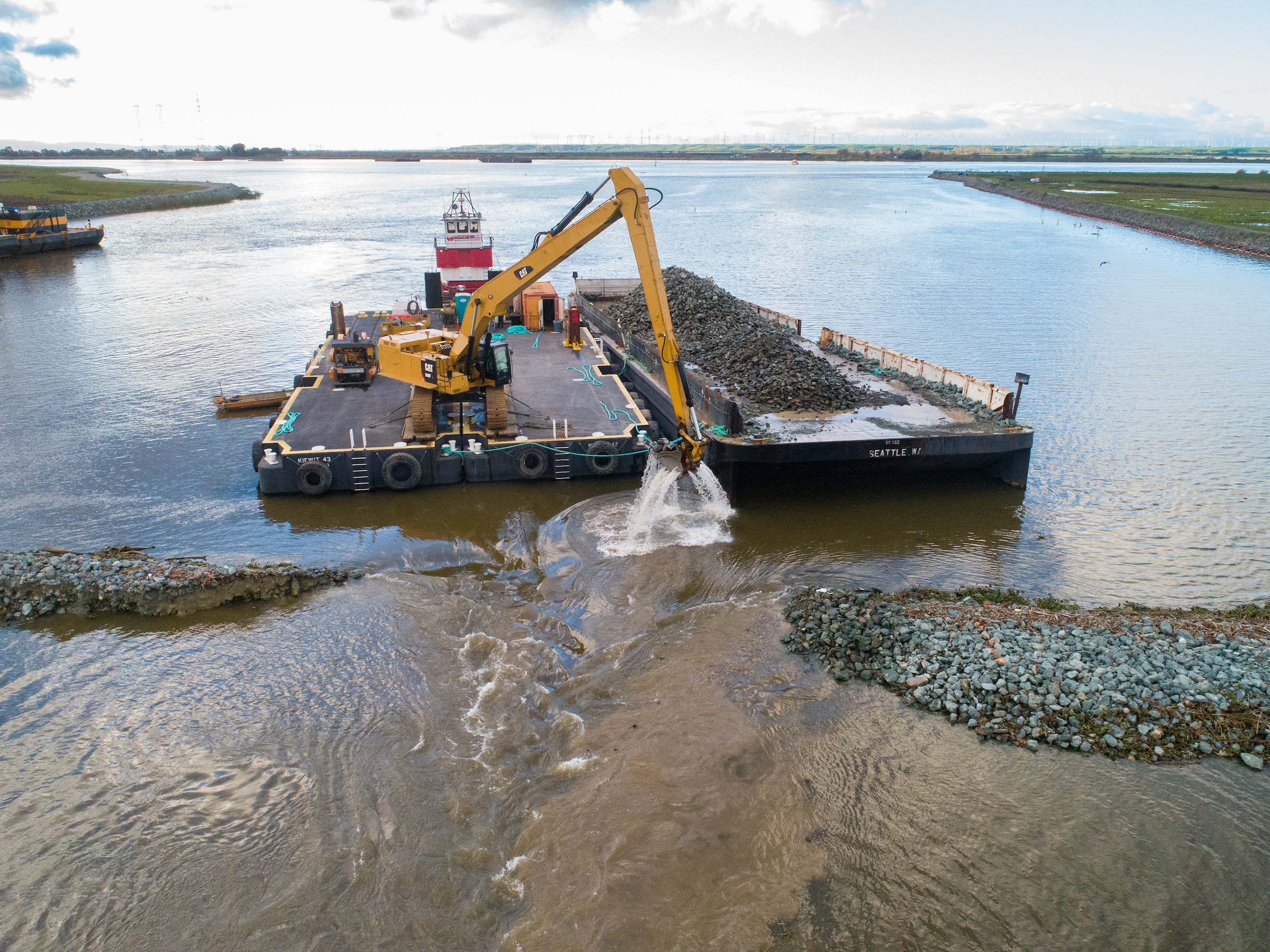
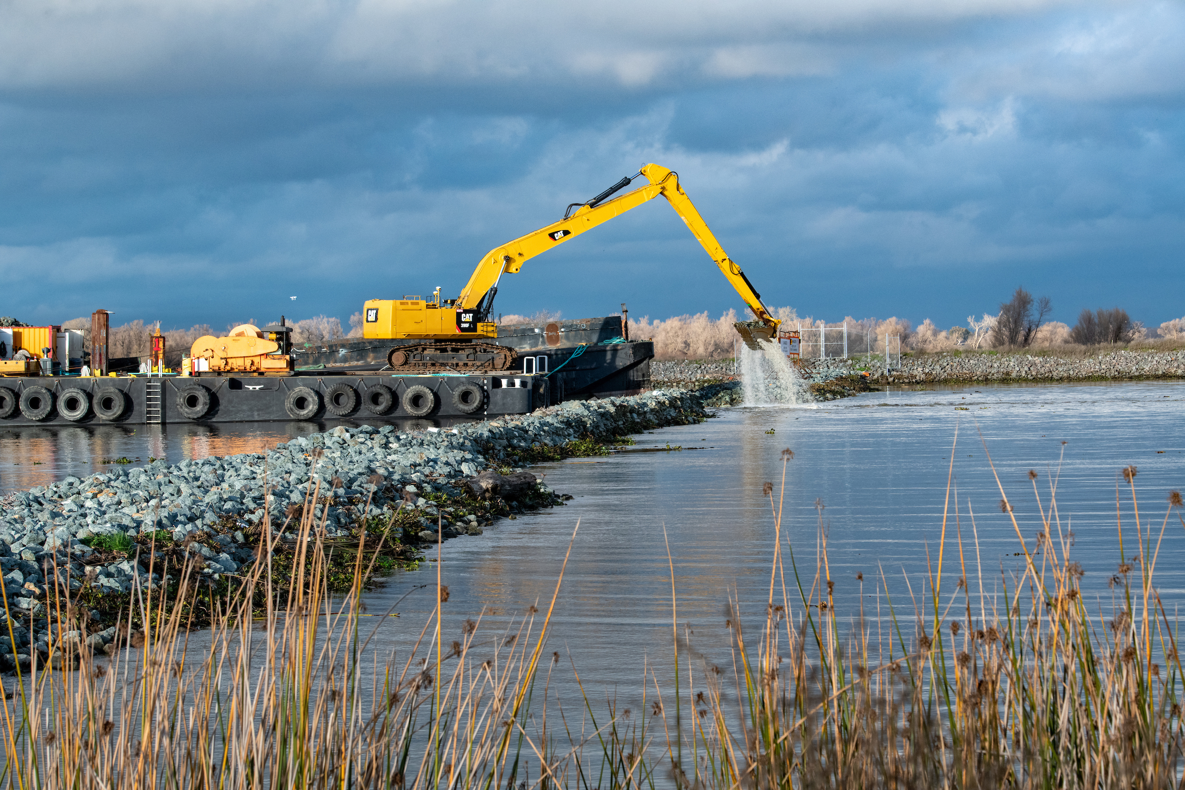
Last winter, when they decided to keep the barrier in place rather than removing it in November, managers notched it to allow vessels and fish to pass through. But managers found the notch acted like a high-pressure nozzle, more harmful than helpful to salmon and smelt caught in the flow or trapped in eddies (where they might be eaten). They still aren’t sure, however, if the river is an important migratory pathway for fish.
“Their chances of survival go down once they get into Franks Tract and into the interior Delta,” says McQuirk. In the coming years, DWR and other agencies plan to conduct more intensive acoustic telemetry monitoring of tagged fish to better understand which life stages of salmon use False River and how it affects their survival. Last year DWR completed a study evaluating predation at the barrier and will determine if any tagged salmon were detected by acoustic receivers (early estimates suggest at least 40 were detected last year). Acoustic telemetry will continue into 2023. “We want to pin down if passage is an important thing for West False River,” says McQuirk.
Modeled tracking of the movement of particles on an ebb tide, as surrogates for juvenile salmon entering the San Joaquin River from the Mokelumne River. The modeling shows how fish might be pulled into Franks Tract or Old River. Source: RMA
Another question in barrier management is how to prevent it from contributing to harmful algal blooms (HABs) and the already excessive growth of invasive weeds in Franks Tract. Neither of these are good for native fish, recreational water quality, or drinking water supply.
HABs were not a problem when the barrier was in place in 2015, but they were in 2021 and 2022. It is not known what caused the change. Since the barrier impairs flows, it can increase the residence time of water in Franks Tract, possibly exacerbating HAB problems.
To flush the HABs, concerned observers proposed inserting some culverts with flap gates to block flood tides but allow ebb tides through the rock barrier. While initially it seemed like a good fix, modeling suggested otherwise. “It would have taken 48, forty-inch-wide culverts to make a dent in the residence time,” says DWR’s Ateljevich. “When you look at culverts and notches, it’s hard to make a difference without ruining the salinity intrusion protections afforded by the barrier. Trying to change the barrier design is like working in handcuffs, shackles, and ankle bracelets.” A smaller-scale approach to culverts could possibly help with localized stagnation in the future, however, suggests Gartrell.
Long Term Plug—Franks Tract
The new point-of-no-return monitoring station reflects growing recognition that with drought, changes in snowpack and runoff, climate change, and sea-level rise, managers will have less and less freshwater at their fingertips to push the nasty saltwater out of the way. Sea-level rise, in particular, is going to push the entire system of salinity standards and physical barriers to the mat.
There may come a time soon when all the usual antidotes to “losing control” might not be enough in climate-changed Delta to keep water flowing to our faucets and irrigation intakes. There is a more permanent solution waiting in the wings however: plugging the West False River with a tidal marsh. Since 2017, a collaborative group of scientists, engineers and planners led by Cal Fish & Wildlife has been working with residents of the communities around Franks Tract (such as Bethel Island) to redesign the landscape of this 3,000-acre flooded island.
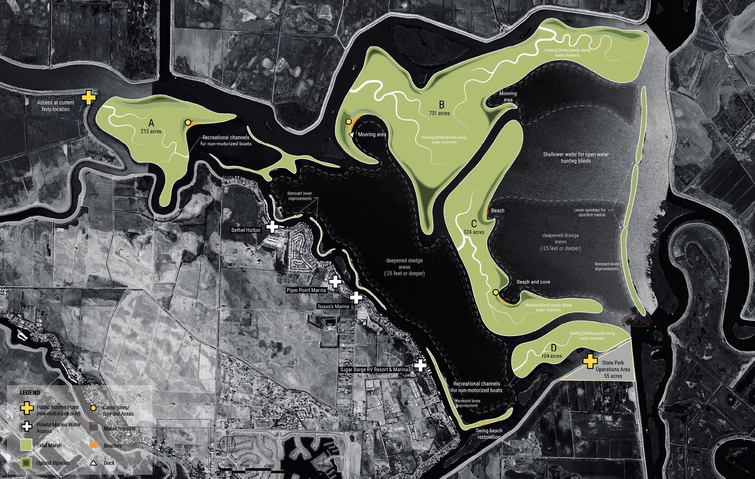
Proposed remodeling of Franks Tract, today a lake, tomorrow a possible multi-benefit project protecting recreation, fish habitat and fresh water supply. Map: ESA
“In its current state, Franks Tract is a really big, really bad actor in the central Delta,” says USGS’s Jon Burau. “It’s like Mount Shasta in terms of salinity intrusion. It creates its own weather.”
The most recent “Franks Tract Futures” proposal is for a multi-benefit project that would deepen some areas of the Tract to prevent invasive weed growth and use the dredged material to create new land masses. Some masses would offer recreational amenities like boat docks and beaches, and others tidal marsh and native fish habitat. About 213 acres of tidal marsh (of 1,300 total created by the project) would be placed in the West False River, creating not only excellent native fish habitat but also a permanent natural drought barrier.
Most interesting, perhaps, is the considerable effort that has gone into co-designing the project with the local residents living, boating, and fishing on the Franks Tract waterfront. While painstaking slow, this co-design and community outreach effort, led by a UC Davis team of facilitators, has turned local opponents of the project into advocates. “It’s a wonderful example of how to bring the social aspect into Delta planning efforts,” says McQuirk. The project is perhaps the most well-developed, long-term solution to the salinity management problem in the Delta, but it will take a big commitment of both federal and state dollars and five to ten years of planning and permitting to “really button everything up for construction,” says McQuirk.
The project also addresses changes ahead. “The restoration remains resilient as sea level goes up,” says Ateljevich. “It’s also a bit more energetically balanced than a big pile of sharp rocks that the tides deflect off. It’s a softer, squishier, more energy-absorbent solution.”
Of course, the projected price tag is huge, up to about $560 million. By comparison, DWR will spend about $20 million on the 2021-2022 barrier (including the change order to notch it). Over time, however, the investment in the longer-term solution begins to look more favorable, especially with sea-level rise and subsidence advancing inexorably, and the chance of a megastorm or megaearthquake looming.
“Franks Tract Futures could help the Delta get back to a more functional, more natural state, and be a big win for habitat and salinity management,” says McQuirk.
Changing the Landscape
Franks Tract is just one example of many steps we could take to change the landscape of the Delta to better manage tidal intrusion and create more habitat for fish.
“The tides are lazy, they take the least path of resistance,” says USGS’ Jon Burau. Manipulating the tides by changing the landscape could not only help mitigate the salinity intrusion problem in the Central Delta, he says, but also provide myriad ecosystem benefits, including increasing the production of fish food from shallows and marshes, connecting habitats that produce organic carbon (such as the Deep Water Ship Channel) with those habitats that accumulate it (lower estuary mixing zones), and as a result, improving juvenile salmon survival.
“One of biggest advantages of manipulating the tides is that these solutions do not depend on fresh water to create positive outcomes, increasing the resiliency of water deliveries and ecosystem services during droughts,” says Burau.
Construction crews notch the drought barrier in the West False River in January 2022 to allow fish and vessels to pass through. Photo: DWR
Global forces such as sea-level rise will also spur some other landscape changes, whatever we do. But as Gartrell points out, there could be some interesting side benefits we should pay more attention to: “Sea-level rise increases the depths of channels, which increases salinity intrusion, but if we let the channels fill in by not dredging, so the depth change is less, we can reduce the salinity increase. Constructing or restoring tidal habitat in the north, south or east Delta could achieve the same benefits.”
In the long run, Delta planners will have to think more about how to combine temporary interventions like rock barriers and long-term landscape changes like the creation of new marshes, floodplains, and fish habitats. Unfortunately, most of these projects are carried out in isolation and could negatively interact, says Burau: “We need numerical modeling to ensure these large-scale projects act synergistically to improve Delta conditions.”
Meanwhile, the Delta Stewardship Council’s science program recognizes the need for “anticipatory, creative planning” to manage salinity in the Delta under future stressors such as recurring drought and sea-level rise, which is why it is hosting the intensive workshop series this year.
“During the current and previous droughts, we’ve gotten more creative about how we use and conserve our limited freshwater, but actions like the emergency salinity drought barrier might be considered a stopgap measure, which also has harmful repercussions for recreation, in-Delta economies, and invasive species control,” says the Council’s lead scientist Laurel Larsen. “In fact, any action to manage salinity in the Delta during drought—be it regulatory, demand reduction, nature-based solutions like wetland restoration, or traditional engineering—will be associated with tradeoffs, and we don’t yet have a good handle on what those tradeoffs of existing and possible future strategies are for human communities and ecosystems.”
As of today, we haven’t quite reached the point of no return. But it’s looking dicey.
Callie Rhoades contributed to reporting for this story.
Top Photo: Notching the drought barrier. Photo: Florence Low, DWR
Ariel Rubissow Okamoto is both today’s editor-in-chief and the founding editor of ESTUARY magazine (1992-2001). She enjoys writing in-depth, silo-crossing stories about water, restoration, and science. She’s a co-author of a Natural History of San Francisco Bay (UC Press 2011), frequent contributor of climate change stories to Bay Nature magazine, and occasional essayist for publications like the San Francisco Chronicle (see her Portfolio here). In other lives, she has been a vintner, soccer mom, and waitress. She lives in San Francisco close to the Bay with her architect husband Paul Okamoto.
Our magazine’s media motto for many years has been “Where there’s an estuary, there’s a crowd.” The San Francisco Estuary is a place where people, wildlife, and commerce congregate, and where watersheds, rivers and the ocean meet and mix, creating a place of unusual diversity. In choosing to tell the...
Ever since the state and federal water projects were built in the 1930s and 1940s, California has captured snowmelt in foothill reservoirs, and moved the fresh water from dam releases and river outflows to parched parts of the state via aqueducts hundreds of miles long. A convoluted system of ancient...
Though the Clean Water Act did an amazing job of reducing wastewater and stormwater pollution of the San Francisco Estuary, some contaminants remain thorny problems. Legacy pollutants like mercury washed into the watershed from upstream gold mining, PCBs from old industrial sites, and selenium from agricultural drainage in the San...
Hothouse Earth
By Ariel Rubissow Okamoto
Photo by Megan Nguyen
Nothing could be stranger than sitting in the dark with thousands of suits and heels, watching a parade of promises to decarbonize from companies and countries large and small, reeling from the beauties of big screen rainforests and indigenous necklaces, and getting all choked up.
It was day two of the September 2018 Global Climate Action Summit in San Francisco when I felt it.
At first I wondered if I was simply starstruck. Most of us labor away trying to fix one small corner of the planet or another without seeing the likes of Harrison Ford, Al Gore, Michael Bloomberg, Van Jones, Jerry Brown – or the ministers or mayors of dozens of cities and countries – in person, on stage and at times angry enough to spit. And between these luminaries a steady stream of CEOs, corporate sustainability officers, and pension fund managers promising percentages of renewables and profits in their portfolios dedicated to the climate cause by 2020-2050.
I tried to give every speaker my full attention: the young man of Vuntut Gwichin heritage from the edge of the Yukon’s Arctic National Wildlife Refuge who pleaded with us not to enter his sacred lands with our drills and dependencies; all the women – swathed in bright patterns and head-scarfs – who kept punching their hearts. “My uncle in Uganda would take 129 years to emit the same amount of carbon as an American would in one year,” said Oxfam’s Winnie Byanyima.
“Our janitors are shutting off the lights you leave on,” said Aida Cardenas, speaking about the frontline workers she trains, mostly immigrants, who are excited to be part of climate change solutions in their new country.
The men on the stage, strutting about in feathers and pinstripes, spoke of hopes and dreams, money and power. “The notion that you can either do good or do well is a myth we have to collectively bust,” said New Jersey Governor Phil Murphy whose state is investing heavily in offshore wind farms.
“Climate change isn’t just about risks, it’s about opportunities,” said Blackrock sustainable investment manager Brian Deese.
But it wasn’t all these fine speeches that started the butterflies. Halfway through the second day of testimonials, it was a slight white-haired woman wrapped in an azure pashmina that pricked my tears. One minute she was on the silver screen with Alec Baldwin and the next she taking a seat on stage. She talked about trees. How trees can solve 30% of our carbon reduction problem. How we have to stop whacking them back in the Amazon and start planting them everywhere else. I couldn’t help thinking of Dr. Seuss and his truffala trees. Jane Goodall, over 80, is as fierce as my Lorax. Or my daughter’s Avatar.
Analyzing my take home feeling from the event I realized it wasn’t the usual fear – killer storms, tidal waves, no food for my kids to eat on a half-baked planet – nor a newfound sense of hope – I’ve always thought nature will get along just fine without us. What I felt was relief. People were actually doing something. Doing a lot. And there was so much more we could do.
As we all pumped fists in the dark, as the presentations went on and on and on because so many people and businesses and countries wanted to STEP UP, I realized how swayed I had let myself be by the doomsday news mill.
“We must be like the river, “ said a boy from Bangladesh named Risalat Khan, who had noticed our Sierra watersheds from the plane. “We must cut through the mountain of obstacles. Let’s be the river!”
Or as Harrison Ford less poetically put it: “Let’s turn off our phones and roll up our sleeves and kick this monster’s ass.”
4th California Climate Change Assessment Blues
by Isaac Pearlman
Since California’s last state-led climate change assessment in 2012, the Golden State has experienced a litany of natural disasters. This includes four years of severe drought from 2012 to 2016, an almost non-existent Sierra Nevada snowpack in 2014-2015 costing $2.1 billion in economic losses, widespread Bay Area flooding from winter 2017 storms, and extremely large and damaging wildfires culminating with this year’s Mendocino Complex fire achieving the dubious distinction of the largest in state history. California’s most recent climate assessment, released August 27th, predicts that for the state and the Bay Area, we can expect even more in the future.
The California state government first began assessing climate impacts formally in 2006, due to an executive order by Governor Schwarzenegger. California’s latest iteration and its fourth overall, includes a dizzying array of 44 technical reports; three topical studies on climate justice, tribal and indigenous communities, and the coast and ocean; as well as nine region-specific analyses.
The results are alarming for our state’s future: an estimated four to five feet of sea level rise and loss of one to two-thirds of Southern California beaches by 2100, a 50 percent increase in wildfires over 25,000 acres, stronger and longer heat waves, and infrastructure like airports, wastewater treatment plants, rail and roadways increasingly likely to suffer flooding.
For the first time, California’s latest assessment dives into climate consequences on a regional level. Academics representing nine California regions spearheaded research and summarized the best available science on the variable heat, rain, flooding and extreme event consequences for their areas. For example, the highest local rate of sea level rise in the state is at the rapidly subsiding Humboldt Bay. In San Diego county, the most biodiverse in all of California, preserving its many fragile and endangered species is an urgent priority. Francesca Hopkins from UC Riverside found that the highest rate of childhood asthma in the state isn’t an urban smog-filled city but in the Imperial Valley, where toxic dust from Salton Sea disaster chokes communities – and will only become worse as higher temperatures and less water due to climate change dry and brittle the area.
According to the Bay Area Regional Report, since 1950 the Bay Area has already increased in temperature by 1.7 degrees Fahrenheit and local sea level is eight inches higher than it was one hundred years ago. Future climate will render the Bay Area less suitable for our evergreen redwood and fir forests, and more favorable for tolerant chaparral shrub land. The region’s seven million people and $750 billion economy (almost one-third of California’s total) is predicted to be increasingly beset by more “boom and bust” irregular wet and very dry years, punctuated by increasingly intense and damaging storms.
Unsurprisingly, according to the report the Bay Area’s intensifying housing and equity problems have a multiplier affect with climate change. As Bay Area housing spreads further north, south, and inland the result is higher transportation and energy needs for those with the fewest resources available to afford them; and acute disparity in climate vulnerability across Bay Area communities and populations.
“All Californians will likely endure more illness and be at greater risk of early death because of climate change,” bluntly states the statewide summary brochure for California’s climate assessment. “[However] vulnerable populations that already experience the greatest adverse health impacts will be disproportionately affected.”
“We’re much better at being reactive to a disaster than planning ahead,” said UC Berkeley professor and contributing author David Ackerly at a California Adaptation Forum panel in Sacramento on August 27th. “And it is vulnerable communities that suffer from those disasters. How much human suffering has to happen before it triggers the next round of activity?”
The assessment’s data is publicly available online at “Cal-adapt,” where Californians can explore projected impacts for their neighborhoods, towns, and regions.


 The results are alarming for our state’s future: an estimated four to five feet of sea level rise and loss of one to two-thirds of Southern California beaches by 2100, a 50 percent increase in wildfires over 25,000 acres, stronger and longer heat waves, and infrastructure like airports, wastewater treatment plants, rail and roadways increasingly likely to suffer flooding.