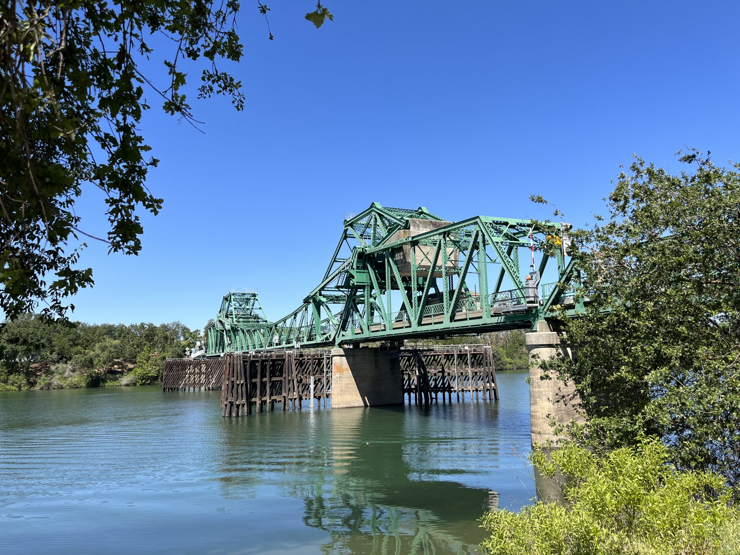
The moveable bridges that cross the rivers and sloughs in the Sacramento-San Joaquin Delta were built in the first half of the 20th century, and most are operated by control panels as old as the bridges themselves. A day spent touring these strong-boned grande dames on backwater levee roads or zigzagging across the Sacramento River on scenic State Route 160 is time well spent. But that’s leisure time, and for the tens of thousands of commuters who use the heavily trafficked corridors of the Delta, the four-to-twenty-minute wait for a bridge to open for marine vessels can be frustrating.
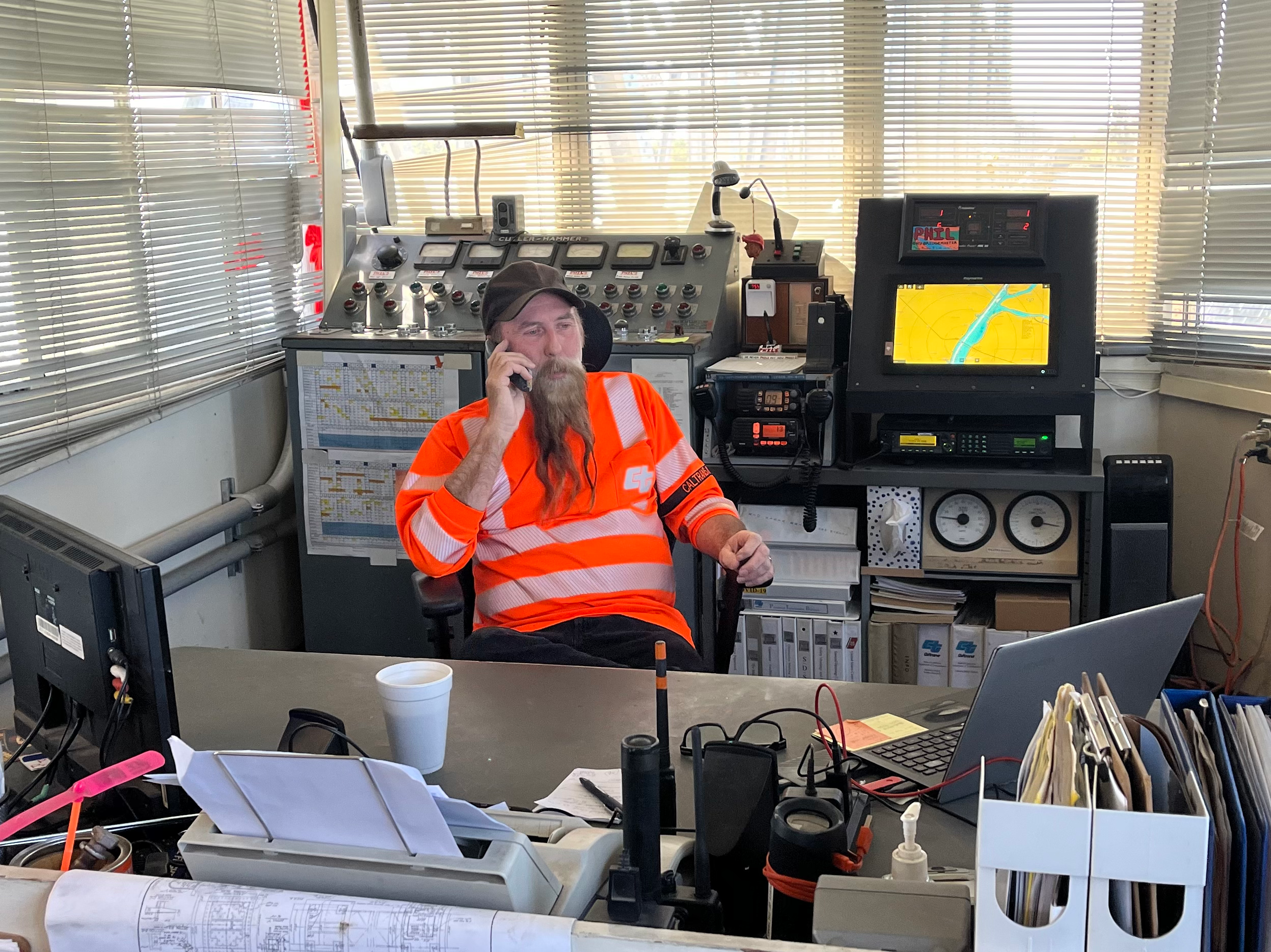
Although vehicles far outnumber vessels these days, watercraft has the right of way. “When we open the bridge, we follow United States Coast Guard rules and regulations,” says Rio Vista Bridge operator Phil Pezzaglia, citing federal regulations for navigation and navigable waters that a drawbridge must open “promptly and fully” upon request from a vessel.
Phil Pezzaglia, operator of the Rio Vista Bridge. Photo: Aleta George.
When road vehicles proliferated a century ago, bridges were needed to cross the waterways of the 55 constructed islands in the Delta. Today, on Georgiana Slough and the Sacramento, Mokelumne, and San Joaquin rivers alone, there are 22 narrow moveable bridges that represent three types: Bascule bridges that leaf open with the help of concrete counterweights; swing bridges that pivot from a fixed, central point; and vertical lift bridges that raise a segment of the roadway between two towers. On average, the two-lane bridges are 23-feet wide, a tight squeeze for two seven-foot-wide full-size SUVs to pass.
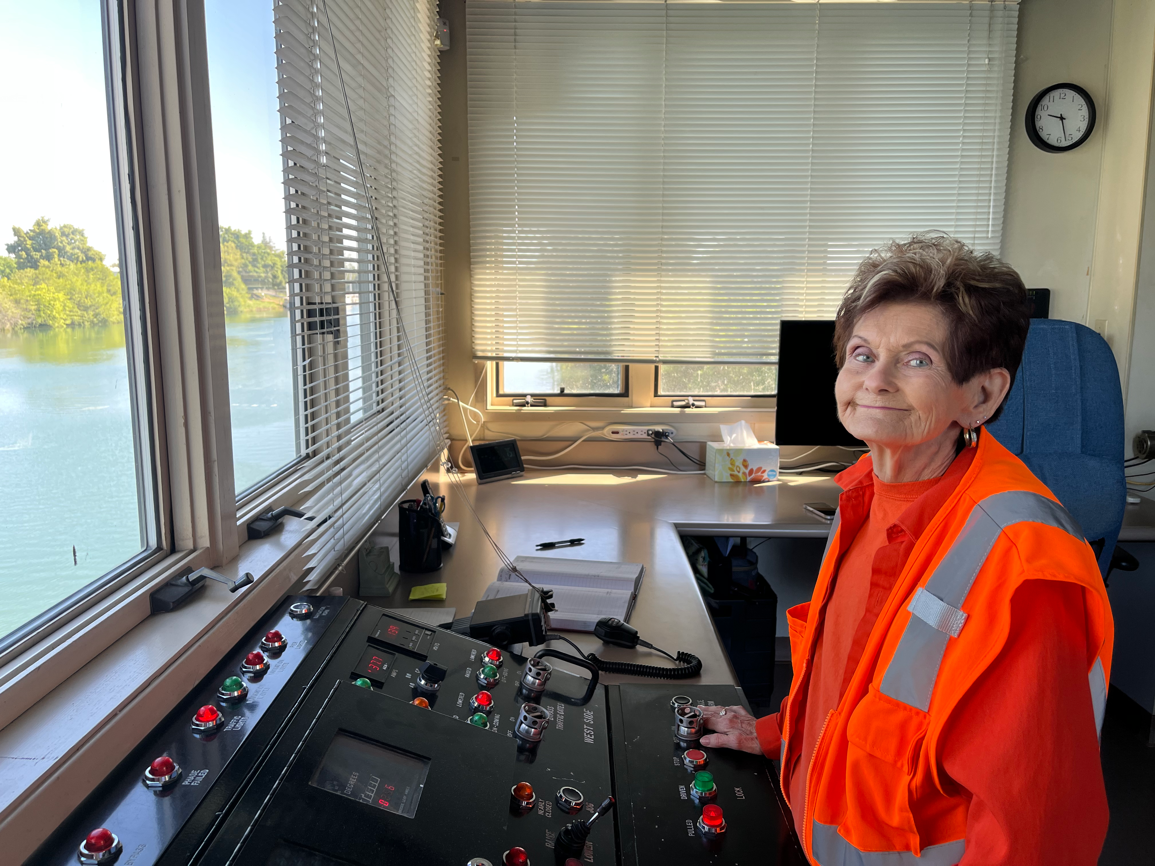
All the bridges in the Delta are controlled by operators or tenders, who are either stationed at the bridge house or on call. Hope Kirch, 77 years old, has been an operator at the Walnut Grove Bridge for 21 years. Built in 1951, this Bascule bridge connects east and west Walnut Grove.
“The Walnut Grove Bridge is our gem,” says Bill Rowton, bridge operations supervisor for Sacramento County, which manages the bridge along with four others.
I visited the bridge one spring morning with Kirch on duty in the bridge house. Before opening upon request from a vessel by phone, radio, or a long and short blast of their horn, Kirch sounds a warning bell and goes outside to ensure the bridge is clear. Once the cars have stopped and the bridge is free of pedestrians, she lowers the traffic safety gates and moves inside to open the bridge from the original control panel.
The two leaves open and rise in the middle with a grinding metallic sound, causing nesting swallows to panic and fly in circles. When Kirch isn’t opening or closing the bridge, she enjoys watching river otters, sea lions, and swallows from the bridge house.
Bridge tender Hope Kirch. Photo: Aleta George
Roughly 6,600 vehicles cross Walnut Grove Bridge daily, but on an early Saturday morning only about 20 vehicles had to wait for the four-minute opening. In 2021, the bridge opened 591 times, less than two times a day.
Different agencies own, manage, and operate the bridges. Caltrans District 4 is in charge of six, including the Mokelumne River Bridge. Built in 1942, this swing bridge crosses the Mokelumne River on California SR-12 and has the greatest number of openings among all Delta bridges. In 2019, the bridge made way for boats approximately 1,600 times, says Pezzaglia. Nestled into tules on the banks of the river below the bridge, I clocked a seven-minute swing. While seven minutes doesn’t sound like long, traffic can back up fast with up to 21,000 vehicles driving SR-12 daily, with nearly all of those crossing the Mokelumne and Rio Vista bridges.
The Rio Vista Bridge (also called the Helen Madere Memorial Bridge) is one of five vertical lift bridges in California, and you can see its two lift towers from miles away. The original Rio Vista Bridge was a Bascule bridge (like the Walnut Grove Bridge) built in 1918. Construction of a new bridge started in 1943 on the east side, but due to World War II steel shortages didn’t conclude until 1960, when it was named the most beautiful steel bridge in its class by the American Institute of Steel Construction.
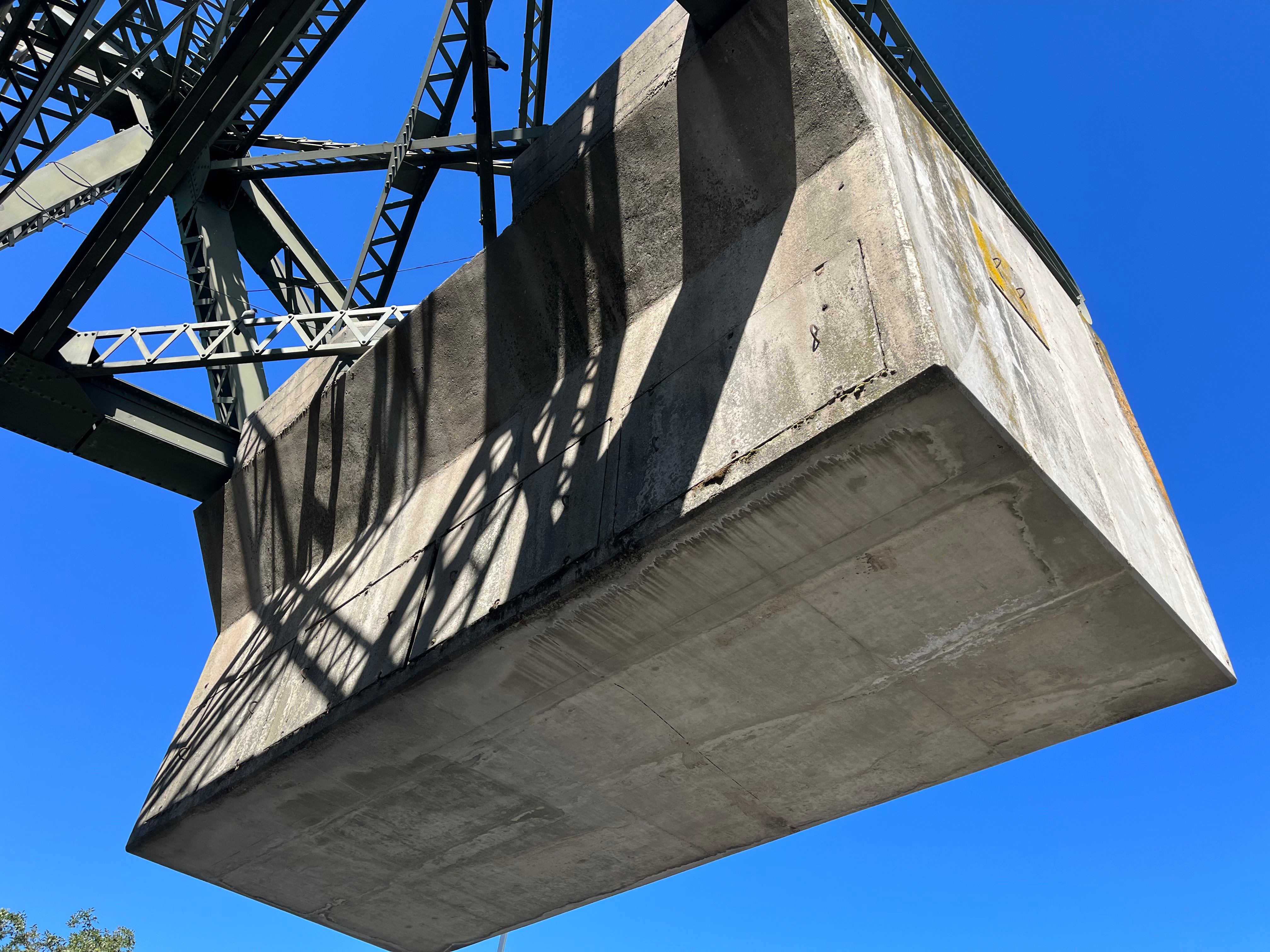
Walnut Grove Bridge counterweight. Photo: Aleta George.
The 306-foot-long lift span provides 135 feet of vertical clearance for vessels, a height that is necessary to accommodate cargo ships traveling to the Port of Sacramento in the Sacramento River Deep Water Ship Channel. Last year the bridge opened 974 times, an average of less than three times a day.
The process of lifting and lowering the span for marine traffic requires vehicles to stop for about 20 minutes, a significant wait made longer when cars ignore the amber, then red, lights signaling that the bridge is about to close to traffic. “At an intersection, people stop their cars at a red light. When you have a bridge with a red light, it seems people say, ‘Put your foot on the gas!’” Pezzaglia says. “I have counted as many as 50 cars that blow through the red light.”
Once the cars do stop, Pezzaglia engages the safety gates on the roadway and walkway, and raises the safety barriers. These precautions are warranted. According to a 1944 article in the Sacramento Bee, a tomato farmer travelling across the old bridge didn’t notice that the span was opening. By the time he did, he had to jump out of his truck. His truck smashed into the side of the bridge, the farmer got 36 stitches, and the bridge was left with a ketchup clean-up.
On the modern-day bridge, the operator pushes buttons and levers on the control panel (the original from the 1960s) to lift the span at 50 to 60 feet per minute. A safety feature ensures that both sides are rising equally. If a five-inch skew is surpassed, the process will stop.
Freeport Bridge. Photo: Aleta George
But it wasn’t a screwy skew that infamously gummed up the Rio Vista Bridge in 2018; it was a failed gear box. At about 2:30 pm on Thursday, August 9, the operator opened the bridge, but couldn’t get it down and traffic backed up for miles. Specialty crews from Caltrans District 3 (which owns the bridge) and District 4 (which maintains and operates it) were able to lower the lift span by Saturday. Then it was stuck in the down position. To accommodate vessels, a team of electricians and engineers devised a workaround with fuel-powered winches, and crews with radios on both towers coordinated a lift that would not exceed that five-inch skew. They used the technique to raise and lower the bridge for more than three weeks until the repaired gear box came back from the manufacturer.
To ensure that nothing like this recurred, Caltrans put in place an emergency repair plan to upgrade the bridge’s mechanical and electrical systems. New backup drives for each tower have been installed, and next year Caltrans will put in new drives for the main system. Upgrades to the bridge house include an automated identification system for tracking vessels and a camera system to monitor the bridge. The estimated cost of the emergency upgrade is $32 million, which will include a new lightweight pavement for the lift span.
The steel bridges in the Delta are old, but safe and sound, says Caltrans project manager Soka Soka. “On the Rio Vista Bridge we’re putting in a new electro-mechanical operating system to catch up with the available, modern technologies. It’s like we’re giving life to an old thing with new blood circulation.”
Yet even with a new circulatory system, the Rio Vista Bridge will take 20 minutes to lift and lower, a wait made more bearable if only commuters would embrace the views of pontists (old-bridge enthusiasts) who travel to the Delta to enjoy the unique history of these grande old dames.
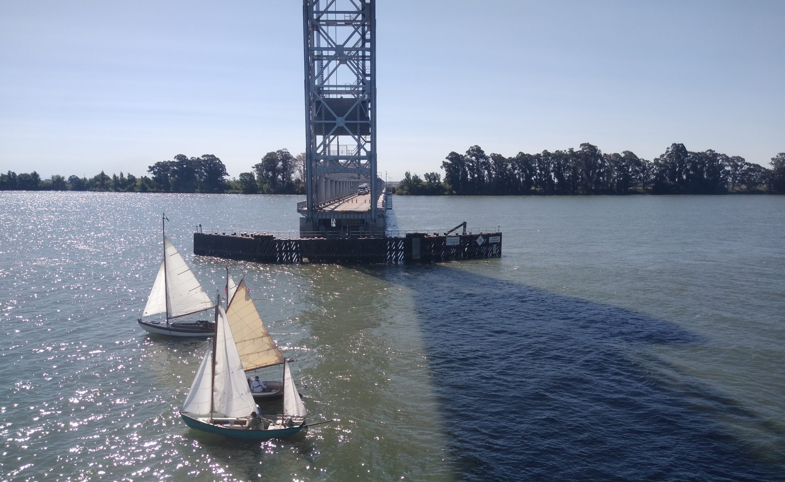
Top image: Sailboats crossing under Delta drawbridge. Photo: Caltrans.
Our magazine’s media motto for many years has been “Where there’s an estuary, there’s a crowd.” The San Francisco Estuary is a place where people, wildlife, and commerce congregate, and where watersheds, rivers and the ocean meet and mix, creating a place of unusual diversity. In choosing to tell the...
Ever since the state and federal water projects were built in the 1930s and 1940s, California has captured snowmelt in foothill reservoirs, and moved the fresh water from dam releases and river outflows to parched parts of the state via aqueducts hundreds of miles long. A convoluted system of ancient...
Though the Clean Water Act did an amazing job of reducing wastewater and stormwater pollution of the San Francisco Estuary, some contaminants remain thorny problems. Legacy pollutants like mercury washed into the watershed from upstream gold mining, PCBs from old industrial sites, and selenium from agricultural drainage in the San...
Hothouse Earth
By Ariel Rubissow Okamoto
Photo by Megan Nguyen
Nothing could be stranger than sitting in the dark with thousands of suits and heels, watching a parade of promises to decarbonize from companies and countries large and small, reeling from the beauties of big screen rainforests and indigenous necklaces, and getting all choked up.
It was day two of the September 2018 Global Climate Action Summit in San Francisco when I felt it.
At first I wondered if I was simply starstruck. Most of us labor away trying to fix one small corner of the planet or another without seeing the likes of Harrison Ford, Al Gore, Michael Bloomberg, Van Jones, Jerry Brown – or the ministers or mayors of dozens of cities and countries – in person, on stage and at times angry enough to spit. And between these luminaries a steady stream of CEOs, corporate sustainability officers, and pension fund managers promising percentages of renewables and profits in their portfolios dedicated to the climate cause by 2020-2050.
I tried to give every speaker my full attention: the young man of Vuntut Gwichin heritage from the edge of the Yukon’s Arctic National Wildlife Refuge who pleaded with us not to enter his sacred lands with our drills and dependencies; all the women – swathed in bright patterns and head-scarfs – who kept punching their hearts. “My uncle in Uganda would take 129 years to emit the same amount of carbon as an American would in one year,” said Oxfam’s Winnie Byanyima.
“Our janitors are shutting off the lights you leave on,” said Aida Cardenas, speaking about the frontline workers she trains, mostly immigrants, who are excited to be part of climate change solutions in their new country.
The men on the stage, strutting about in feathers and pinstripes, spoke of hopes and dreams, money and power. “The notion that you can either do good or do well is a myth we have to collectively bust,” said New Jersey Governor Phil Murphy whose state is investing heavily in offshore wind farms.
“Climate change isn’t just about risks, it’s about opportunities,” said Blackrock sustainable investment manager Brian Deese.
But it wasn’t all these fine speeches that started the butterflies. Halfway through the second day of testimonials, it was a slight white-haired woman wrapped in an azure pashmina that pricked my tears. One minute she was on the silver screen with Alec Baldwin and the next she taking a seat on stage. She talked about trees. How trees can solve 30% of our carbon reduction problem. How we have to stop whacking them back in the Amazon and start planting them everywhere else. I couldn’t help thinking of Dr. Seuss and his truffala trees. Jane Goodall, over 80, is as fierce as my Lorax. Or my daughter’s Avatar.
Analyzing my take home feeling from the event I realized it wasn’t the usual fear – killer storms, tidal waves, no food for my kids to eat on a half-baked planet – nor a newfound sense of hope – I’ve always thought nature will get along just fine without us. What I felt was relief. People were actually doing something. Doing a lot. And there was so much more we could do.
As we all pumped fists in the dark, as the presentations went on and on and on because so many people and businesses and countries wanted to STEP UP, I realized how swayed I had let myself be by the doomsday news mill.
“We must be like the river, “ said a boy from Bangladesh named Risalat Khan, who had noticed our Sierra watersheds from the plane. “We must cut through the mountain of obstacles. Let’s be the river!”
Or as Harrison Ford less poetically put it: “Let’s turn off our phones and roll up our sleeves and kick this monster’s ass.”
4th California Climate Change Assessment Blues
by Isaac Pearlman
Since California’s last state-led climate change assessment in 2012, the Golden State has experienced a litany of natural disasters. This includes four years of severe drought from 2012 to 2016, an almost non-existent Sierra Nevada snowpack in 2014-2015 costing $2.1 billion in economic losses, widespread Bay Area flooding from winter 2017 storms, and extremely large and damaging wildfires culminating with this year’s Mendocino Complex fire achieving the dubious distinction of the largest in state history. California’s most recent climate assessment, released August 27th, predicts that for the state and the Bay Area, we can expect even more in the future.
The California state government first began assessing climate impacts formally in 2006, due to an executive order by Governor Schwarzenegger. California’s latest iteration and its fourth overall, includes a dizzying array of 44 technical reports; three topical studies on climate justice, tribal and indigenous communities, and the coast and ocean; as well as nine region-specific analyses.
The results are alarming for our state’s future: an estimated four to five feet of sea level rise and loss of one to two-thirds of Southern California beaches by 2100, a 50 percent increase in wildfires over 25,000 acres, stronger and longer heat waves, and infrastructure like airports, wastewater treatment plants, rail and roadways increasingly likely to suffer flooding.
For the first time, California’s latest assessment dives into climate consequences on a regional level. Academics representing nine California regions spearheaded research and summarized the best available science on the variable heat, rain, flooding and extreme event consequences for their areas. For example, the highest local rate of sea level rise in the state is at the rapidly subsiding Humboldt Bay. In San Diego county, the most biodiverse in all of California, preserving its many fragile and endangered species is an urgent priority. Francesca Hopkins from UC Riverside found that the highest rate of childhood asthma in the state isn’t an urban smog-filled city but in the Imperial Valley, where toxic dust from Salton Sea disaster chokes communities – and will only become worse as higher temperatures and less water due to climate change dry and brittle the area.
According to the Bay Area Regional Report, since 1950 the Bay Area has already increased in temperature by 1.7 degrees Fahrenheit and local sea level is eight inches higher than it was one hundred years ago. Future climate will render the Bay Area less suitable for our evergreen redwood and fir forests, and more favorable for tolerant chaparral shrub land. The region’s seven million people and $750 billion economy (almost one-third of California’s total) is predicted to be increasingly beset by more “boom and bust” irregular wet and very dry years, punctuated by increasingly intense and damaging storms.
Unsurprisingly, according to the report the Bay Area’s intensifying housing and equity problems have a multiplier affect with climate change. As Bay Area housing spreads further north, south, and inland the result is higher transportation and energy needs for those with the fewest resources available to afford them; and acute disparity in climate vulnerability across Bay Area communities and populations.
“All Californians will likely endure more illness and be at greater risk of early death because of climate change,” bluntly states the statewide summary brochure for California’s climate assessment. “[However] vulnerable populations that already experience the greatest adverse health impacts will be disproportionately affected.”
“We’re much better at being reactive to a disaster than planning ahead,” said UC Berkeley professor and contributing author David Ackerly at a California Adaptation Forum panel in Sacramento on August 27th. “And it is vulnerable communities that suffer from those disasters. How much human suffering has to happen before it triggers the next round of activity?”
The assessment’s data is publicly available online at “Cal-adapt,” where Californians can explore projected impacts for their neighborhoods, towns, and regions.


 The results are alarming for our state’s future: an estimated four to five feet of sea level rise and loss of one to two-thirds of Southern California beaches by 2100, a 50 percent increase in wildfires over 25,000 acres, stronger and longer heat waves, and infrastructure like airports, wastewater treatment plants, rail and roadways increasingly likely to suffer flooding.