As a source of flowing water, upper Coyote Creek is unreliable at best. Though storms swell its banks in winter, Mediterranean-climate summers shrink this South Bay stream to a series of isolated pools by August.
“By October right before the rains come, we’re down to these really small pools that have all the fish in them,” says retired U.S. Environmental Protection Agency ecologist Rob Leidy.
Leidy and UC Berkeley fish ecologist Stephanie Carlson began monitoring the annual dry-down of upper Coyote Creek in 2014, with the help of Hana Moidu and other graduate students. The creek itself originates in Henry W. Coe State Park and flows to the Bay through Coyote and Anderson lakes south of San Jose.
The scientists have found that while the intermittent reach of creek above Coyote Lake appears to be a death trap for aquatic organisms, it is actually dominated by native fishes and other wildlife. This makes Coyote Creek a rarity among California’s highly invaded, diverted, and degraded waterways. In dry times, the pools are a West Coast version of the Serengeti’s famous watering holes: they teem with wildlife ranging from lizards and snakes to mountain lions and deer.
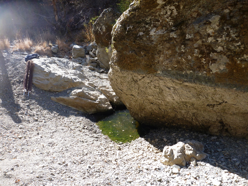
Persistent boulder in Kelly Cabin Creek in upper Coyote Creek Watershed. Photo: Robert Leidy.
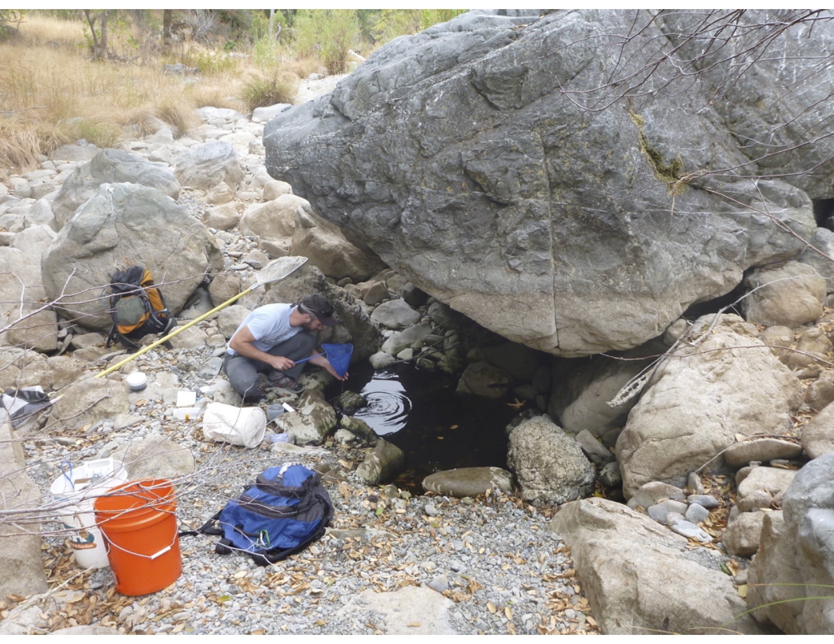
Across six years of surveys, the scientists have also noticed another peculiar detail: the pools that persist are always in the same locations. Given the importance of the pools for wildlife, the researchers wondered why some endure while others tend to evaporate. The most reliable, they found, had several features in common. Many were adjacent to massive, sometimes house-size boulders. Landslides had tumbled the boulders into the river from the steep banks.
“The thought is that the high-water flows of winter will scour deep along the boulder and form deep pockets for water,” says Moidu. “Often at the end of the summer season, this is the only surface water that remains.” The boulders also offer shade, slowing evaporation.
The most persistent pools also possess a secret source of water: an underground spring. The five-kilometer study reach begins just downstream of Gilroy Hot Springs, which flows even through the driest summers. Yet this hidden water supply only became clear after the extraordinary rains of 2017. “It was only in that really wet year that we saw surface connections to several springs along our study reach,” Carlson says. “It made us realize that perhaps in drier years, there was a subsurface spring connection that might have been contributing to the persistence of those pools.”
The springs arise from the fact that Coyote Creek lies in earthquake country. A fault runs along the creek’s length. Cracks in the bedrock underlying the creek bed allow groundwater to fill the pools.
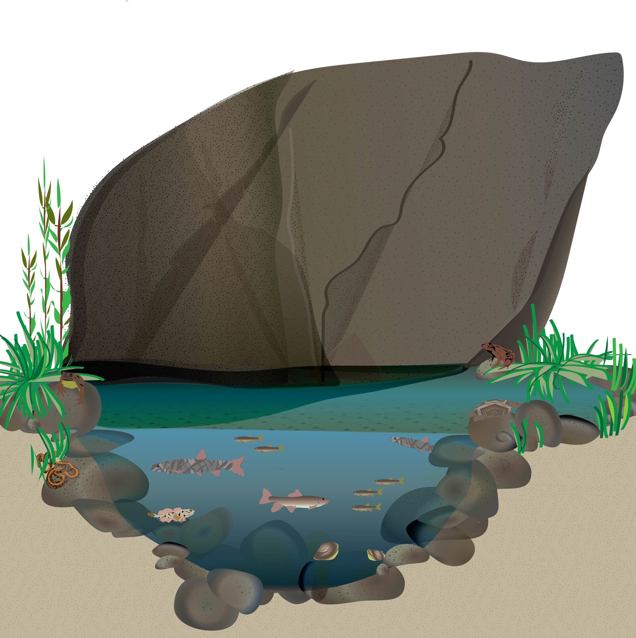
Diagram of boulder habitat by Hana Moidu, a UC Berkeley graduate student who has led the monitoring and data analysis of the species harbored by Coyote Creek’s pools since 2016.
“These pools are disconnected from the annual rainfall because the water that comes into many of the pools is from deep aquifers,” Leidy says. “This decouples them in the short term from the effects of drought.”
Conditions within pools depend heavily on their size. The largest, deepest pools are cooler and have more dissolved oxygen, enabling them to host larger adult fishes, as well as species such as the endangered red-legged frog. By contrast, temperatures in shallower pools can go from the 50s at night to the 80s on hot afternoons, pushing animals to their thermal limits. The most common vertebrates in these puddles tend to be small organisms such as juvenile southern coastal California roach.
The team has even found one native fish that doesn’t require open water to survive. The Pacific brook lamprey can wriggle its wormlike body into the few centimeters of water around the cobbles and gravel lining an otherwise dry pool. Within this hyporheic zone, the lamprey can lay low for weeks until rain returns.
Beneath the surface of this “Middle Pool” swim five native fish species: Southern coastal roach, Sacramento sucker, Sacramento pikeminnow, Ohlone sculpin (formally riffle sculpin), and brook lamprey, as well as frogs and turtles. Photo: Rob Leidy.
“It seems many native species have adaptations that allow them to tolerate these very harsh conditions,” Carlson says. The more natural flows in intermittent streams, the researchers suspect, keeps non-native fish species at bay. Yet these intermittent waterways, she says, “are very underappreciated in terms of their importance for supporting regional biodiversity.”
In California, intermittent streams make up more than half of the state’s river miles. Along those, Leidy has found summer pools in waterways such as Alameda Creek, as well as streams in the Diablo Range, northern intercoastal range, and Central Valley foothills. But he suspects there are far more.
“It might be a really good strategy to go out and identify areas where these persistent pools are located,” he says. “Then you can target those areas as refuges to climate change in the future.”
Top Photo: Scientist Mike Bogan sampling a deep pool. Photo: Rob Leidy.
Bay Area native Kathleen M. Wong is a science writer specializing in the natural history and environment of California and the West. With Ariel Rubissow Okamoto, she coauthored Natural History of San Francisco Bay (UC Press, 2011), for which she shared the 2013 Harold Gilliam Award for Excellence in Environmental Reporting. She reports on native species, climate change, and environmental conditions for Estuary, and is the science writer of the University of California Natural Reserve System.
Our magazine’s media motto for many years has been “Where there’s an estuary, there’s a crowd.” The San Francisco Estuary is a place where people, wildlife, and commerce congregate, and where watersheds, rivers and the ocean meet and mix, creating a place of unusual diversity. In choosing to tell the...
Ever since the state and federal water projects were built in the 1930s and 1940s, California has captured snowmelt in foothill reservoirs, and moved the fresh water from dam releases and river outflows to parched parts of the state via aqueducts hundreds of miles long. A convoluted system of ancient...
Though the Clean Water Act did an amazing job of reducing wastewater and stormwater pollution of the San Francisco Estuary, some contaminants remain thorny problems. Legacy pollutants like mercury washed into the watershed from upstream gold mining, PCBs from old industrial sites, and selenium from agricultural drainage in the San...
Hothouse Earth
By Ariel Rubissow Okamoto
Photo by Megan Nguyen
Nothing could be stranger than sitting in the dark with thousands of suits and heels, watching a parade of promises to decarbonize from companies and countries large and small, reeling from the beauties of big screen rainforests and indigenous necklaces, and getting all choked up.
It was day two of the September 2018 Global Climate Action Summit in San Francisco when I felt it.
At first I wondered if I was simply starstruck. Most of us labor away trying to fix one small corner of the planet or another without seeing the likes of Harrison Ford, Al Gore, Michael Bloomberg, Van Jones, Jerry Brown – or the ministers or mayors of dozens of cities and countries – in person, on stage and at times angry enough to spit. And between these luminaries a steady stream of CEOs, corporate sustainability officers, and pension fund managers promising percentages of renewables and profits in their portfolios dedicated to the climate cause by 2020-2050.
I tried to give every speaker my full attention: the young man of Vuntut Gwichin heritage from the edge of the Yukon’s Arctic National Wildlife Refuge who pleaded with us not to enter his sacred lands with our drills and dependencies; all the women – swathed in bright patterns and head-scarfs – who kept punching their hearts. “My uncle in Uganda would take 129 years to emit the same amount of carbon as an American would in one year,” said Oxfam’s Winnie Byanyima.
“Our janitors are shutting off the lights you leave on,” said Aida Cardenas, speaking about the frontline workers she trains, mostly immigrants, who are excited to be part of climate change solutions in their new country.
The men on the stage, strutting about in feathers and pinstripes, spoke of hopes and dreams, money and power. “The notion that you can either do good or do well is a myth we have to collectively bust,” said New Jersey Governor Phil Murphy whose state is investing heavily in offshore wind farms.
“Climate change isn’t just about risks, it’s about opportunities,” said Blackrock sustainable investment manager Brian Deese.
But it wasn’t all these fine speeches that started the butterflies. Halfway through the second day of testimonials, it was a slight white-haired woman wrapped in an azure pashmina that pricked my tears. One minute she was on the silver screen with Alec Baldwin and the next she taking a seat on stage. She talked about trees. How trees can solve 30% of our carbon reduction problem. How we have to stop whacking them back in the Amazon and start planting them everywhere else. I couldn’t help thinking of Dr. Seuss and his truffala trees. Jane Goodall, over 80, is as fierce as my Lorax. Or my daughter’s Avatar.
Analyzing my take home feeling from the event I realized it wasn’t the usual fear – killer storms, tidal waves, no food for my kids to eat on a half-baked planet – nor a newfound sense of hope – I’ve always thought nature will get along just fine without us. What I felt was relief. People were actually doing something. Doing a lot. And there was so much more we could do.
As we all pumped fists in the dark, as the presentations went on and on and on because so many people and businesses and countries wanted to STEP UP, I realized how swayed I had let myself be by the doomsday news mill.
“We must be like the river, “ said a boy from Bangladesh named Risalat Khan, who had noticed our Sierra watersheds from the plane. “We must cut through the mountain of obstacles. Let’s be the river!”
Or as Harrison Ford less poetically put it: “Let’s turn off our phones and roll up our sleeves and kick this monster’s ass.”
4th California Climate Change Assessment Blues
by Isaac Pearlman
Since California’s last state-led climate change assessment in 2012, the Golden State has experienced a litany of natural disasters. This includes four years of severe drought from 2012 to 2016, an almost non-existent Sierra Nevada snowpack in 2014-2015 costing $2.1 billion in economic losses, widespread Bay Area flooding from winter 2017 storms, and extremely large and damaging wildfires culminating with this year’s Mendocino Complex fire achieving the dubious distinction of the largest in state history. California’s most recent climate assessment, released August 27th, predicts that for the state and the Bay Area, we can expect even more in the future.
The California state government first began assessing climate impacts formally in 2006, due to an executive order by Governor Schwarzenegger. California’s latest iteration and its fourth overall, includes a dizzying array of 44 technical reports; three topical studies on climate justice, tribal and indigenous communities, and the coast and ocean; as well as nine region-specific analyses.
The results are alarming for our state’s future: an estimated four to five feet of sea level rise and loss of one to two-thirds of Southern California beaches by 2100, a 50 percent increase in wildfires over 25,000 acres, stronger and longer heat waves, and infrastructure like airports, wastewater treatment plants, rail and roadways increasingly likely to suffer flooding.
For the first time, California’s latest assessment dives into climate consequences on a regional level. Academics representing nine California regions spearheaded research and summarized the best available science on the variable heat, rain, flooding and extreme event consequences for their areas. For example, the highest local rate of sea level rise in the state is at the rapidly subsiding Humboldt Bay. In San Diego county, the most biodiverse in all of California, preserving its many fragile and endangered species is an urgent priority. Francesca Hopkins from UC Riverside found that the highest rate of childhood asthma in the state isn’t an urban smog-filled city but in the Imperial Valley, where toxic dust from Salton Sea disaster chokes communities – and will only become worse as higher temperatures and less water due to climate change dry and brittle the area.
According to the Bay Area Regional Report, since 1950 the Bay Area has already increased in temperature by 1.7 degrees Fahrenheit and local sea level is eight inches higher than it was one hundred years ago. Future climate will render the Bay Area less suitable for our evergreen redwood and fir forests, and more favorable for tolerant chaparral shrub land. The region’s seven million people and $750 billion economy (almost one-third of California’s total) is predicted to be increasingly beset by more “boom and bust” irregular wet and very dry years, punctuated by increasingly intense and damaging storms.
Unsurprisingly, according to the report the Bay Area’s intensifying housing and equity problems have a multiplier affect with climate change. As Bay Area housing spreads further north, south, and inland the result is higher transportation and energy needs for those with the fewest resources available to afford them; and acute disparity in climate vulnerability across Bay Area communities and populations.
“All Californians will likely endure more illness and be at greater risk of early death because of climate change,” bluntly states the statewide summary brochure for California’s climate assessment. “[However] vulnerable populations that already experience the greatest adverse health impacts will be disproportionately affected.”
“We’re much better at being reactive to a disaster than planning ahead,” said UC Berkeley professor and contributing author David Ackerly at a California Adaptation Forum panel in Sacramento on August 27th. “And it is vulnerable communities that suffer from those disasters. How much human suffering has to happen before it triggers the next round of activity?”
The assessment’s data is publicly available online at “Cal-adapt,” where Californians can explore projected impacts for their neighborhoods, towns, and regions.


 The results are alarming for our state’s future: an estimated four to five feet of sea level rise and loss of one to two-thirds of Southern California beaches by 2100, a 50 percent increase in wildfires over 25,000 acres, stronger and longer heat waves, and infrastructure like airports, wastewater treatment plants, rail and roadways increasingly likely to suffer flooding.