The naming of boats and ships is a serious matter. Each larger vessel’s name starts with a code that tells what it carries, what propels it, or what purpose it serves. If it were your hobby to keep tabs on traffic on San Francisco Bay, you’d see a lot of big UCCs (container ships) and TCHs and TCRs (tankers). You’d see ferries emblazoned with MV, standing for “motor vessel.” Before COVID-19, you would have spotted the occasional SS, standing for “single screw” but meaning a passenger liner. And if you looked hard you might see the occasional modest hull labeled RV. RV stands for research vessel. Seeing these letters, you know you’re looking at one of the indispensable craft that take scientists and their gear to collect data from the waters and sediments of San Francisco Bay and the Delta.
Watching Bay-Delta science unfold, we take for granted the little armada that keeps it all going. But, like many of the systems that quietly sustain our society, this one is showing signs of strain.
Nobody has a firm count, but it appears there are about 100 vessels supporting research in the Estuary. They range from a few large craft that can work outside the Golden Gate to little “trailerable” skiffs and Adirondack rowboats that ply Delta shallows. Some, like the U.S. Geological Survey’s RV Turning Tide, belong to federal agencies. Others, like the California Department of Fish and Wildlife’s RV Longfin, are state-owned. Important ones, like San Francisco State’s RVQuestuary, are university assets and double as floating classrooms. Still others, like Dixon Marine’s RV Lakota, belong to private companies that lease them out to clients such as the San Francisco Estuary Institute (SFEI), Chevron, and PG&E.
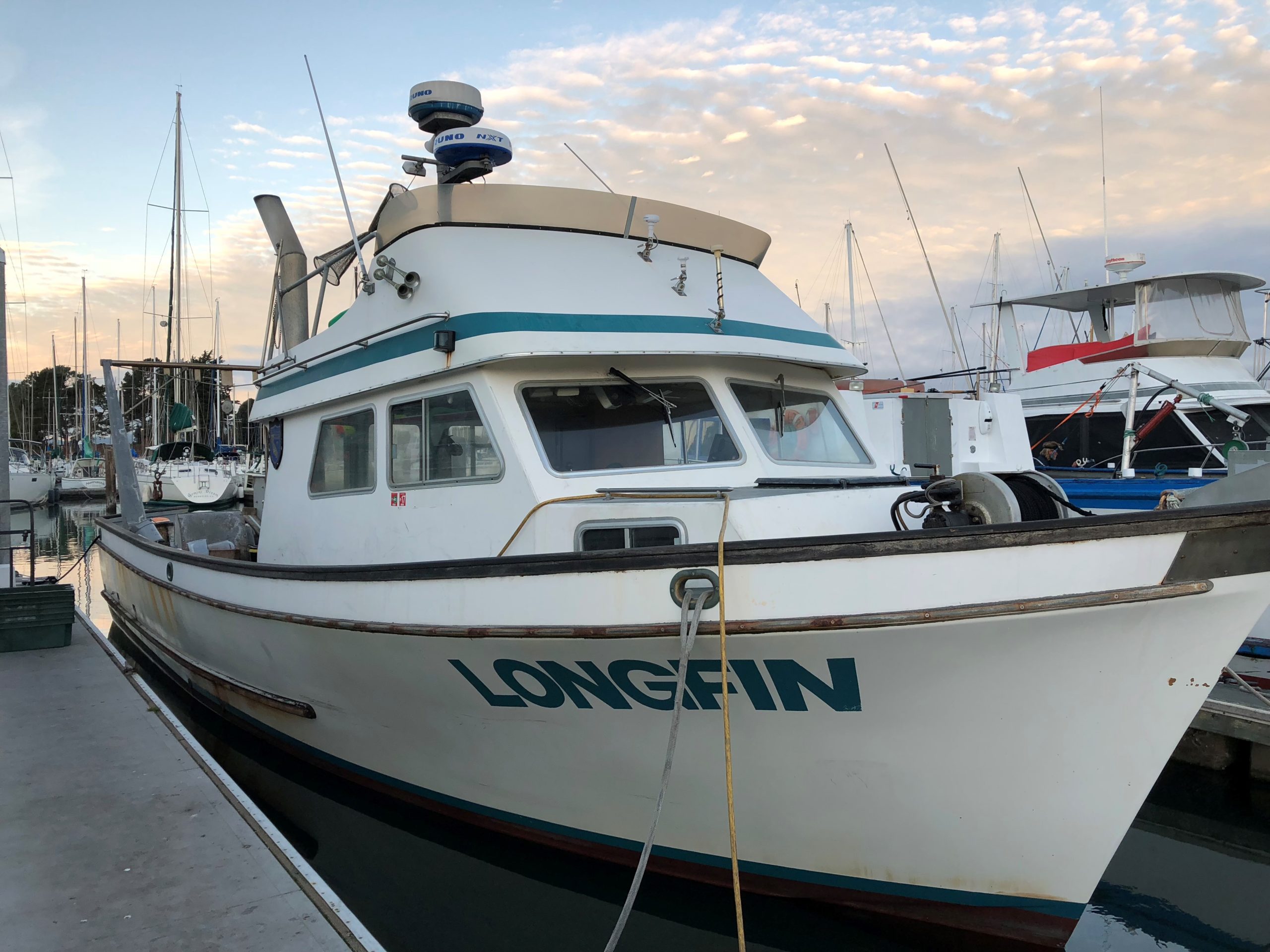
The RV Longfin (42 feet, CDFW), named for the longfin smelt, has been monitoring estuary fish since the 1980s. “It’s pretty much at the end of its life,” says the agency’s Stephanie Fong. Photo: CDFW
About half of this fleet is enrolled with the Interagency Ecological Program, a research cooperative set up in the 1970s to track the effects of water projects and mainly, though not entirely, focused on the Delta. The other half, working largely in the lower Estuary, has not until now had such an organizational umbrella.
Depending on task, research boats need different refinements. Those that tow nets require big A-frame winches to hoist loads in and out of the water. Other boats may make do with lighter “davit” winches. They all need lab space, or at minimum a clean area for filtering and storing water samples. They need various special instruments. And they need crews adept in the special demands of operating a boat for research. “Driving a boat for science is different from driving a boat for other purposes,” says Melissa Foley of SFEI.
This under-appreciated support system has been stretched thin for years. Many vessels, or “hulls” in the language of the field, are approaching the end of their useful lives. Like an old car, an old boat starts having problems two and three at a time. Take the case of the RV Longfin, launched in 1983 and vital to generations of Bay studies. “It’s one thing after the next,” says Steve Culberson of the Interagency Ecological Program (IEP). “As soon as you fix the hydraulics, the exhaust manifold goes down. We’re using scotch tape and baling wire to hold these things together. You need to buy a couple of 1.5- to 2-million-dollar boats every decade to keep the information coming.”
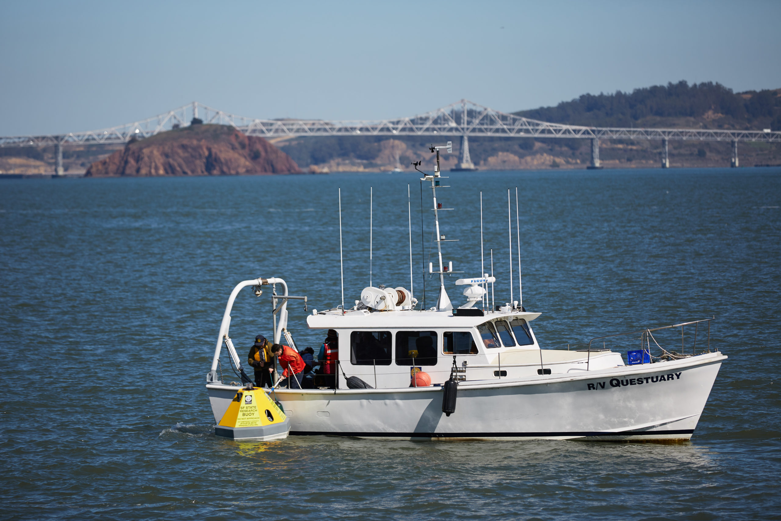
Captains, crews, and maintenance staff are also getting older. San Francisco State’s RV Questuary rocks at the dock in San Rafael, having lost two captains in succession. Now there is a university hiring freeze. Not many young people are mastering the particular skills that make what you might call a research-support mariner.
The RV Questuary (38 feet, SFSU) “is the most capable boat I’ve seen on the water,” says Alex Parker of the California Maritime Academy. Idled for the moment due to lack of crew, it will need replacement, or at least a new engine, in about five years. Photo: Lisa Vortman
State and federal environmental budgets are unpredictable and generally shrinking, leading to a kind of hoarding. Boat-owning agencies are less willing and able to lend their craft to projects outside their core missions and to people from other organizations. The informal swaps and mutual favors that have lubricated the machinery — “Oh, you’re going to Liberty Island, could you scoop up a couple of liters for our zooplankton work?” — become harder to arrange. At the same time, says Foley, “There’s not enough research going on within single agencies to support and pay for individual vessels.”
Sharing boats is an obvious solution, but can bring complications. Liability, for instance. “Who’s an employee and who is not? Who can use a winch?” asks Karina Nielsen of San Francisco State. “If a $50,000 instrument off the side of the boat gets lost, who’s responsible? We are trying to figure that out.”
In recent years, such nagging concerns have ripened into a sense of crisis. At one point in 2017, the IEP’s Longfin missed surveys due to mechanical problems, creating gaps in precious, multi-decade streams of data. By the end of 2018, the IEP had set up a “fleet resilience” team and plan to track the state of the boats and plan for future needs.
It has proven harder than you’d think just to fuse many agencies’ information into a common format. “That doesn’t look like our list!” people complain. As for new craft, it’s unclear who would pay, or how. The six to eight years needed to design and build a boat exceeds the length of the research contracts that structure the program’s funding. “It’s a struggle,” says Stephanie Fong of the Department of Fish and Wildlife.
The IEP has one thing going for it: an ironclad mandate. Without the data it generates, the state and federal pumps that send water south from the Delta would be legally forbidden to function. Even in times of austerity, money for this program’s boats is likely to be found — somehow.
Things are less focused but no less urgent in the lower Estuary. In the fall of 2019, SFEI faced the possibility of losing access to all three boats it relies on for certain pollution studies: the Questuary, the Turning Tide, and the Geological Survey’s Peterson.
Uncertainty over federal budgets hampers the ability of government partners to plan for future sampling cruises like the one shown in this 2019 video. The same uncertainty creates obstacles for local, state and federal collaborators trying to enter into multi-year agreements for critical monitoring initiatives like the Bay’s Nutrient Management Strategy, which helps fund the nutrient monitoring program in the Bay.
In February of this year, when face-to-face meetings were still the norm, a roomful of worried people sat down at SFEI headquarters to map out a better way for the Bay. Again, the obvious first step was to build an inventory of the vessels, their capabilities, and their maintenance needs. The second, parallel step is to get a grasp of research missions expected in the next couple of years.
And after that? At a minimum, the participants agreed, the issues that hamper sharing the existing fleet must be wrestled down. One concrete suggestion: jointly support a new captain for the Questuary.
A longer-term dream is to band together to buy — and staff, and maintain — one or more capable boats for all to share. This would mean creating a new entity, a formal consortium. This option looks even farther off now than it did in pre-COVID days.“ Any new vessel,” Foley says, “is likely to be long delayed.”
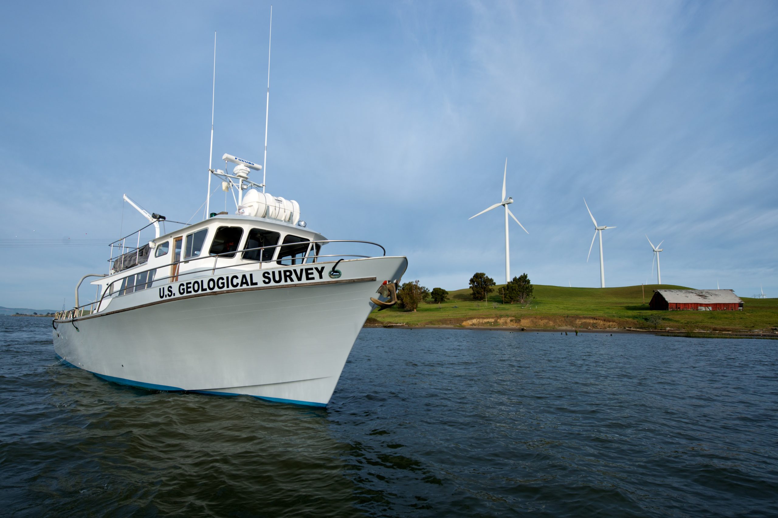
Top Photo: The RV Turning Tide (53 feet, USGS), underused due to staff limitations; is on the water for two weeks every two years in aid of Regional Monitoring Program pollution studies. Photo: USGS
In other news…
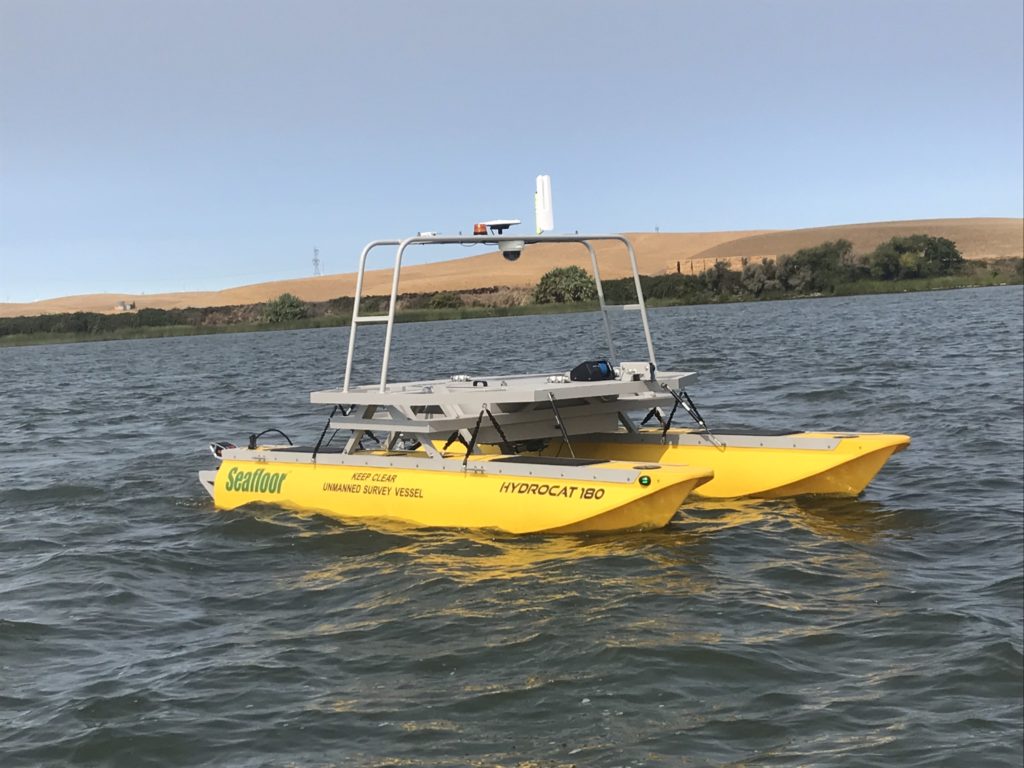
The US Geological Survey recently purchased two autonomous surface vehicles (remote controlled pontoon boats) to help more precisely measure discharges that are used to calibrate velocity measurements adjacent to two stations used to compute Delta Outflow. At these two stations, the San Joaquin River at Jersey Point and the Sacramento River at Rio Vista, the channels are so wide there is a lot of spatial variability in the currents due to tidal changes, which makes it difficult to accurately measure the tidal discharge at these locations. Measurement boats need to go slower than the currents speeds in order to collect reasonable velocity measurements. “These ASVs can go slow and straight as arrow across the river, over the exact same track every time, something that is impossible for a human steering a research vessel to do,” says USGS scientist Jon Burau. Such changes to the monitoring fleet across the Estuary could increase sampling efficiencies and accuracy. Photo: USGS
John Hart is an environmental journalist and author of sixteen books and several hundred other published works. He is also the winner of the James D. Phelan Award, the Commonwealth Club Medal in Californiana, and the David R. Brower Award for Service in the Field of Conservation. For ESTUARY, he writes on groundwater, infrastructure, and California water politics and history.
Our magazine’s media motto for many years has been “Where there’s an estuary, there’s a crowd.” The San Francisco Estuary is a place where people, wildlife, and commerce congregate, and where watersheds, rivers and the ocean meet and mix, creating a place of unusual diversity. In choosing to tell the...
Ever since the state and federal water projects were built in the 1930s and 1940s, California has captured snowmelt in foothill reservoirs, and moved the fresh water from dam releases and river outflows to parched parts of the state via aqueducts hundreds of miles long. A convoluted system of ancient...
Though the Clean Water Act did an amazing job of reducing wastewater and stormwater pollution of the San Francisco Estuary, some contaminants remain thorny problems. Legacy pollutants like mercury washed into the watershed from upstream gold mining, PCBs from old industrial sites, and selenium from agricultural drainage in the San...
Hothouse Earth
By Ariel Rubissow Okamoto
Photo by Megan Nguyen
Nothing could be stranger than sitting in the dark with thousands of suits and heels, watching a parade of promises to decarbonize from companies and countries large and small, reeling from the beauties of big screen rainforests and indigenous necklaces, and getting all choked up.
It was day two of the September 2018 Global Climate Action Summit in San Francisco when I felt it.
At first I wondered if I was simply starstruck. Most of us labor away trying to fix one small corner of the planet or another without seeing the likes of Harrison Ford, Al Gore, Michael Bloomberg, Van Jones, Jerry Brown – or the ministers or mayors of dozens of cities and countries – in person, on stage and at times angry enough to spit. And between these luminaries a steady stream of CEOs, corporate sustainability officers, and pension fund managers promising percentages of renewables and profits in their portfolios dedicated to the climate cause by 2020-2050.
I tried to give every speaker my full attention: the young man of Vuntut Gwichin heritage from the edge of the Yukon’s Arctic National Wildlife Refuge who pleaded with us not to enter his sacred lands with our drills and dependencies; all the women – swathed in bright patterns and head-scarfs – who kept punching their hearts. “My uncle in Uganda would take 129 years to emit the same amount of carbon as an American would in one year,” said Oxfam’s Winnie Byanyima.
“Our janitors are shutting off the lights you leave on,” said Aida Cardenas, speaking about the frontline workers she trains, mostly immigrants, who are excited to be part of climate change solutions in their new country.
The men on the stage, strutting about in feathers and pinstripes, spoke of hopes and dreams, money and power. “The notion that you can either do good or do well is a myth we have to collectively bust,” said New Jersey Governor Phil Murphy whose state is investing heavily in offshore wind farms.
“Climate change isn’t just about risks, it’s about opportunities,” said Blackrock sustainable investment manager Brian Deese.
But it wasn’t all these fine speeches that started the butterflies. Halfway through the second day of testimonials, it was a slight white-haired woman wrapped in an azure pashmina that pricked my tears. One minute she was on the silver screen with Alec Baldwin and the next she taking a seat on stage. She talked about trees. How trees can solve 30% of our carbon reduction problem. How we have to stop whacking them back in the Amazon and start planting them everywhere else. I couldn’t help thinking of Dr. Seuss and his truffala trees. Jane Goodall, over 80, is as fierce as my Lorax. Or my daughter’s Avatar.
Analyzing my take home feeling from the event I realized it wasn’t the usual fear – killer storms, tidal waves, no food for my kids to eat on a half-baked planet – nor a newfound sense of hope – I’ve always thought nature will get along just fine without us. What I felt was relief. People were actually doing something. Doing a lot. And there was so much more we could do.
As we all pumped fists in the dark, as the presentations went on and on and on because so many people and businesses and countries wanted to STEP UP, I realized how swayed I had let myself be by the doomsday news mill.
“We must be like the river, “ said a boy from Bangladesh named Risalat Khan, who had noticed our Sierra watersheds from the plane. “We must cut through the mountain of obstacles. Let’s be the river!”
Or as Harrison Ford less poetically put it: “Let’s turn off our phones and roll up our sleeves and kick this monster’s ass.”
4th California Climate Change Assessment Blues
by Isaac Pearlman
Since California’s last state-led climate change assessment in 2012, the Golden State has experienced a litany of natural disasters. This includes four years of severe drought from 2012 to 2016, an almost non-existent Sierra Nevada snowpack in 2014-2015 costing $2.1 billion in economic losses, widespread Bay Area flooding from winter 2017 storms, and extremely large and damaging wildfires culminating with this year’s Mendocino Complex fire achieving the dubious distinction of the largest in state history. California’s most recent climate assessment, released August 27th, predicts that for the state and the Bay Area, we can expect even more in the future.
The California state government first began assessing climate impacts formally in 2006, due to an executive order by Governor Schwarzenegger. California’s latest iteration and its fourth overall, includes a dizzying array of 44 technical reports; three topical studies on climate justice, tribal and indigenous communities, and the coast and ocean; as well as nine region-specific analyses.
The results are alarming for our state’s future: an estimated four to five feet of sea level rise and loss of one to two-thirds of Southern California beaches by 2100, a 50 percent increase in wildfires over 25,000 acres, stronger and longer heat waves, and infrastructure like airports, wastewater treatment plants, rail and roadways increasingly likely to suffer flooding.
For the first time, California’s latest assessment dives into climate consequences on a regional level. Academics representing nine California regions spearheaded research and summarized the best available science on the variable heat, rain, flooding and extreme event consequences for their areas. For example, the highest local rate of sea level rise in the state is at the rapidly subsiding Humboldt Bay. In San Diego county, the most biodiverse in all of California, preserving its many fragile and endangered species is an urgent priority. Francesca Hopkins from UC Riverside found that the highest rate of childhood asthma in the state isn’t an urban smog-filled city but in the Imperial Valley, where toxic dust from Salton Sea disaster chokes communities – and will only become worse as higher temperatures and less water due to climate change dry and brittle the area.
According to the Bay Area Regional Report, since 1950 the Bay Area has already increased in temperature by 1.7 degrees Fahrenheit and local sea level is eight inches higher than it was one hundred years ago. Future climate will render the Bay Area less suitable for our evergreen redwood and fir forests, and more favorable for tolerant chaparral shrub land. The region’s seven million people and $750 billion economy (almost one-third of California’s total) is predicted to be increasingly beset by more “boom and bust” irregular wet and very dry years, punctuated by increasingly intense and damaging storms.
Unsurprisingly, according to the report the Bay Area’s intensifying housing and equity problems have a multiplier affect with climate change. As Bay Area housing spreads further north, south, and inland the result is higher transportation and energy needs for those with the fewest resources available to afford them; and acute disparity in climate vulnerability across Bay Area communities and populations.
“All Californians will likely endure more illness and be at greater risk of early death because of climate change,” bluntly states the statewide summary brochure for California’s climate assessment. “[However] vulnerable populations that already experience the greatest adverse health impacts will be disproportionately affected.”
“We’re much better at being reactive to a disaster than planning ahead,” said UC Berkeley professor and contributing author David Ackerly at a California Adaptation Forum panel in Sacramento on August 27th. “And it is vulnerable communities that suffer from those disasters. How much human suffering has to happen before it triggers the next round of activity?”
The assessment’s data is publicly available online at “Cal-adapt,” where Californians can explore projected impacts for their neighborhoods, towns, and regions.


 The results are alarming for our state’s future: an estimated four to five feet of sea level rise and loss of one to two-thirds of Southern California beaches by 2100, a 50 percent increase in wildfires over 25,000 acres, stronger and longer heat waves, and infrastructure like airports, wastewater treatment plants, rail and roadways increasingly likely to suffer flooding.