The learned doctors attending the bedside of the Sacramento-San Joaquin River Delta agree on one thing: the patient is not doing well. What ails it, many students of the case suggest, is dehydration: the perennial artificial drought induced by withdrawals of water for human use, whether pulled from feeder rivers or extracted from the Delta itself. The obvious prescription — that society moderate its demands — is politically very hard to fill.
Recently, though, attention has turned to what might be called a comorbidity: malnutrition. Delta waters simply don’t generate enough basic food, in the form of phytoplankton, to sustain the food chains extending to salmon, sturgeon, and smelt. Compared with the problem of thirst, this hunger might actually be a little easier to assuage — if we look for answers in the right, and sometimes unexpected, places.
The diverse floating organisms called phytoplankton build themselves from sunlight and from minerals found in the water. No shortage of solar radiation here. Delta waters have become clearer of late, which was predicted to induce a plankton bloom but did not. The limiting factor, in this part of the world, seems to be nitrogen. Due to upstream dams and agricultural practices, the Sacramento River no longer brings down much of this building-block substance.
Another ingredient in phytoplankton growth is time. Plankton mass may double daily, but the curve rises slowly at first. If nutrients float past too quickly, there’s no time to use them. The modern Delta is a streamlined place, adapted to moving water, not to hoarding it. Whatever nitrogen does find its way in locally, as at the regional sewage treatment plant at Freeport, is hurried out toward San Francisco Bay. (The Bay is thought to have too much of the stuff, but that’s another story.)
“The correct amount of nutrients in water bodies in not zero,” observes Randy Dahlgren of UC Davis. As a proxy for nutrients, we measure chlorophyll. About 10 parts per billion, Dahlgren says, is a good chlorophyll number, nowhere near the excess called eutrophication. In summer, much of the Delta shows readings of 1-3 ppb.
There are some remoter corners of the system, though, where food is not limiting and phytoplankton grows robustly. Researchers are pondering how to expand these oases and distribute local surpluses to impoverished regions. One such fertile spot, the Yolo Bypass, has been studied in depth for decades now. Another, on researchers’ radar for less than ten years, is the Sacramento Deep Water Ship Channel.
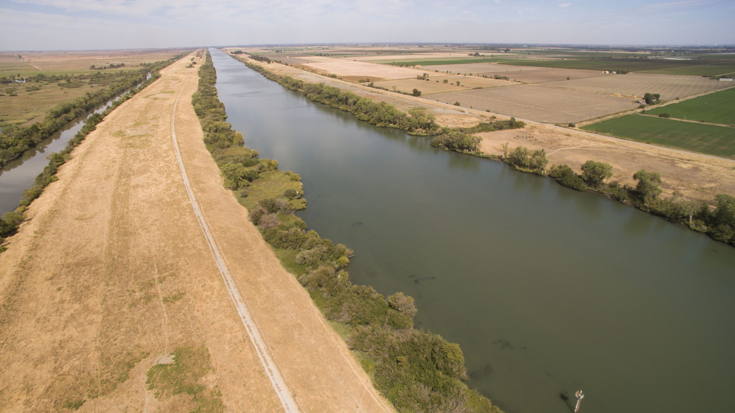
The Channel is a paradox. Opened by the Army Corps of Engineers in 1963, it provides a 26-mile shortcut from the river near Rio Vista to the Port of West Sacramento. Thirty feet deep, arrow-straight for miles, barren of bank, roiled by massive vessels carrying rice out and supplies such as fertilizer in, the channel seems the very opposite of an idyllic Delta slough. Yet this utilitarian ditch behaves in some ways like an aboriginal side channel. It grows plankton. It holds healthily cold water in its depths. And it has proved to be a refuge for Delta smelt. “In the last few years, the channel has been the only place where smelt have been caught in appreciable numbers with any consistency,” says Erwin Van Nieuwenhuyse of the U.S. Bureau of Reclamation.
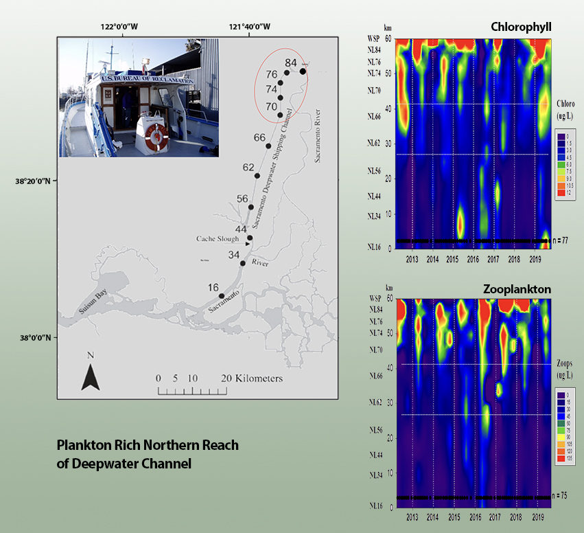
Food production data, as measured by chlorophyll and zooplankton levels, in the northwest section of the Sacramento shipping channel. Chart Data: Erwin Van Nieuwenhuyse, USBR
An interesting place. Yet the long-running Interagency Ecological Program ignored it. The California Department of Fish and Wildlife took its first samples for smelt in 2009. The real research effort dates only to 2012, when Van Nieuwenhuyse and his Bureau colleagues, “out of complete curiosity,” took their research vessel Compliance up the channel for an initial tour.
They found a waterway in three distinct segments. The southern part has strong tidal movements. behaving much like the adjacent river. In a middle section, the tidal rhythm fades and syncopates, stirring up mud and creating a “turbidity maximum”; this is the place to look for smelt. The northern reach was once connected to the upper Sacramento River by a lock for barges, but Stone Lock shut down for good in 2000. Now this segment is like a long, skinny lake, out of reach of the tides but accidentally freshened through a little rift in the bulkhead that was installed above the disused lock structure. The northern tip turns green each spring with algae, making onlookers in West Sacramento think “pollution.”
Pollution, to a biologist, is often only chemicals that are out of place. The problem with these blooms is not that they occur. It is that they stay put too long. The organic matter produced here doesn’t wash down to the middle reach, where animal species might fatten on it. Instead it sinks to the bottom and decays, using up oxygen and locking up nutrients in bottom muds. (Too little circulation, we see here, can be as bad for plankton as too much.)
This ambiguously promising state of affairs stands to change, as authorities debate plans to reconnect the upper channel with the Sacramento — or to separate the waters forever.
The city of West Sacramento owes its existence to levees. As it stands, the leaky bulkhead is a flaw in the protective ring. The Army Corps of Engineers has offered a plan to fix this chink in the armor, closing the gap with 550 more feet of conventional dike. An application for federal funds, for the specified purpose, is pending.
But the city, which now owns the lock along with a section of channel, seeks to make this spot an attractive recreation site and a hub of urban redevelopment. A permanently stagnant pool behind a levee would be a poor centerpiece. Encouraged by the Bureau of Reclamation, the city has been looking at alternatives that would improve, not eliminate, the connection to the Sacramento. If more than the present trickle were allowed to pass, this infusion could make the upper end of the channel more appetizing. It could also, food web researchers note, send more phytoplankton downstream.
Before the pandemic interrupted the planning, a consensus seemed to be forming around an alternative that would install four gated culverts allowing flows of up to 700 cubic feet for second. This is enough capacity to allow a careful manipulation of the food supply. “You would let it cook,” says Van Nieuwenhuyse, “and then push it down.”
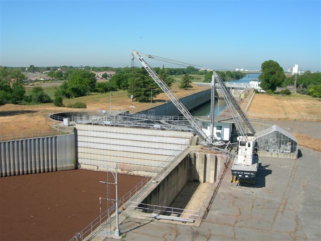
Stone Lock. Photo: Port of West Sacramento
If and when federal money comes through, a full-dress National Environmental Policy Act (NEPA) study, comparing several options, will ensue. Among those options, ship channel researchers hope, will be a yet more ambitious idea. They would like to see Stone Lock restored to a state in which a much wider range of flows could be allowed to pass into the ship channel. Like the culvert option, this plan would permit phytoplankton management downstream. But it could do more. Bigger pulses of water could push floating foodstuffs clear out of the southern end of the channel and into a wider reach of the western Delta.
And there’s another tantalizing possibility. A properly restored connection could give green sturgeon and Chinook salmon a new path to and from the sea. Both young fish headed for the ocean and adults bound upstream to spawn might take this route, avoiding what have been called the “death traps” of the Central Delta.
This is a case where local government finds itself the steward of a regional restoration opportunity. Any new plan, observes West Sacramento’s Katie Yancey, “requires full cooperation and advocacy” from the city, the associated but distinct flood control agency, and likely from the independent Port of West Sacramento as well.
Higher level agencies, of course, will also have their say. The State Water Resources Control Board may well treat the reconnection as a new diversion. Arguably, a water right existed when Stone Lock was functioning, but the records that could quantify it are nowhere to be found. “We literally don’t know how they operated or how much water went down there,” Van Nieuwenhuyse says. He calculates that perhaps 50,000 acre-feet a year would be rerouted. Compared with other adjustments proposed to benefit the Delta ecosystem, he argues, this would be a moderate change.
Indeed many questions remain. But any treatment that could even marginally help the long-declining Delta seems worth probing in full.
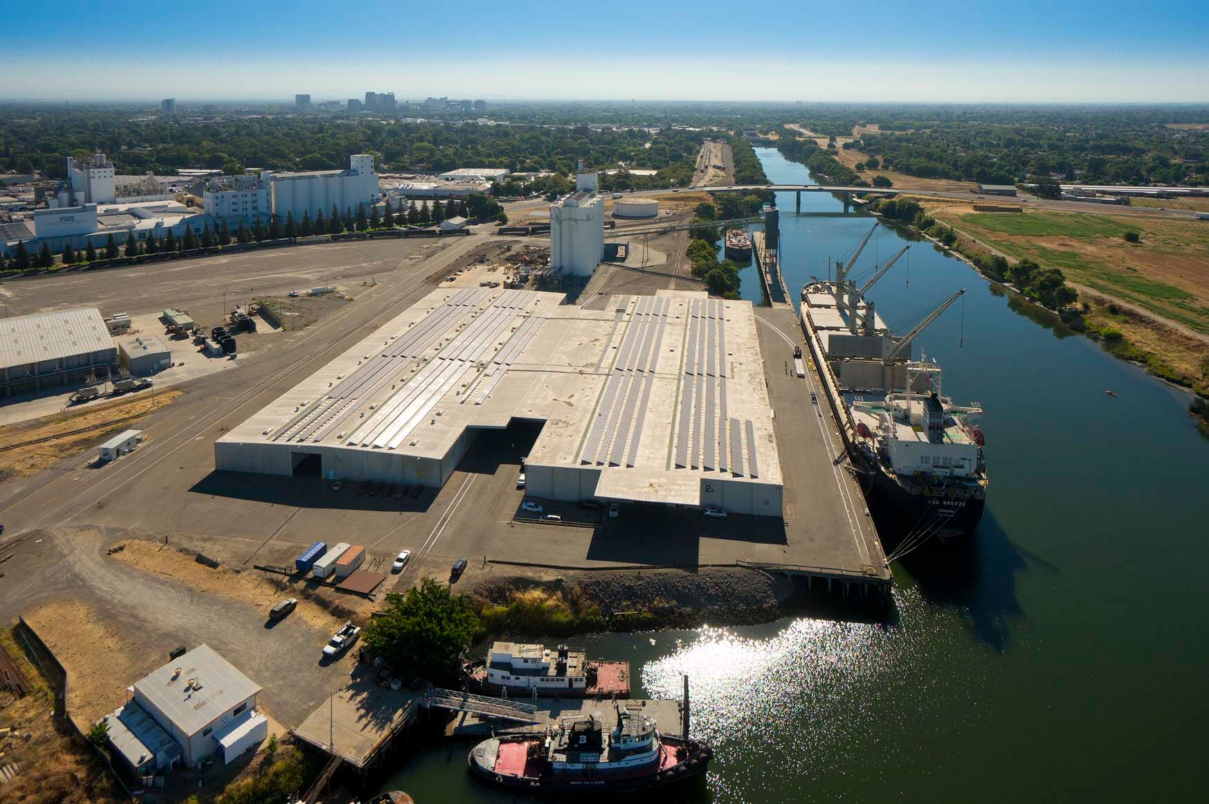
Top Photo: Port of West Sacramento at the northern end of the shipping channel. Photo: Port of West Sacramento
John Hart is an environmental journalist and author of sixteen books and several hundred other published works. He is also the winner of the James D. Phelan Award, the Commonwealth Club Medal in Californiana, and the David R. Brower Award for Service in the Field of Conservation. For ESTUARY, he writes on groundwater, infrastructure, and California water politics and history.
Our magazine’s media motto for many years has been “Where there’s an estuary, there’s a crowd.” The San Francisco Estuary is a place where people, wildlife, and commerce congregate, and where watersheds, rivers and the ocean meet and mix, creating a place of unusual diversity. In choosing to tell the...
Ever since the state and federal water projects were built in the 1930s and 1940s, California has captured snowmelt in foothill reservoirs, and moved the fresh water from dam releases and river outflows to parched parts of the state via aqueducts hundreds of miles long. A convoluted system of ancient...
Though the Clean Water Act did an amazing job of reducing wastewater and stormwater pollution of the San Francisco Estuary, some contaminants remain thorny problems. Legacy pollutants like mercury washed into the watershed from upstream gold mining, PCBs from old industrial sites, and selenium from agricultural drainage in the San...
Hothouse Earth
By Ariel Rubissow Okamoto
Photo by Megan Nguyen
Nothing could be stranger than sitting in the dark with thousands of suits and heels, watching a parade of promises to decarbonize from companies and countries large and small, reeling from the beauties of big screen rainforests and indigenous necklaces, and getting all choked up.
It was day two of the September 2018 Global Climate Action Summit in San Francisco when I felt it.
At first I wondered if I was simply starstruck. Most of us labor away trying to fix one small corner of the planet or another without seeing the likes of Harrison Ford, Al Gore, Michael Bloomberg, Van Jones, Jerry Brown – or the ministers or mayors of dozens of cities and countries – in person, on stage and at times angry enough to spit. And between these luminaries a steady stream of CEOs, corporate sustainability officers, and pension fund managers promising percentages of renewables and profits in their portfolios dedicated to the climate cause by 2020-2050.
I tried to give every speaker my full attention: the young man of Vuntut Gwichin heritage from the edge of the Yukon’s Arctic National Wildlife Refuge who pleaded with us not to enter his sacred lands with our drills and dependencies; all the women – swathed in bright patterns and head-scarfs – who kept punching their hearts. “My uncle in Uganda would take 129 years to emit the same amount of carbon as an American would in one year,” said Oxfam’s Winnie Byanyima.
“Our janitors are shutting off the lights you leave on,” said Aida Cardenas, speaking about the frontline workers she trains, mostly immigrants, who are excited to be part of climate change solutions in their new country.
The men on the stage, strutting about in feathers and pinstripes, spoke of hopes and dreams, money and power. “The notion that you can either do good or do well is a myth we have to collectively bust,” said New Jersey Governor Phil Murphy whose state is investing heavily in offshore wind farms.
“Climate change isn’t just about risks, it’s about opportunities,” said Blackrock sustainable investment manager Brian Deese.
But it wasn’t all these fine speeches that started the butterflies. Halfway through the second day of testimonials, it was a slight white-haired woman wrapped in an azure pashmina that pricked my tears. One minute she was on the silver screen with Alec Baldwin and the next she taking a seat on stage. She talked about trees. How trees can solve 30% of our carbon reduction problem. How we have to stop whacking them back in the Amazon and start planting them everywhere else. I couldn’t help thinking of Dr. Seuss and his truffala trees. Jane Goodall, over 80, is as fierce as my Lorax. Or my daughter’s Avatar.
Analyzing my take home feeling from the event I realized it wasn’t the usual fear – killer storms, tidal waves, no food for my kids to eat on a half-baked planet – nor a newfound sense of hope – I’ve always thought nature will get along just fine without us. What I felt was relief. People were actually doing something. Doing a lot. And there was so much more we could do.
As we all pumped fists in the dark, as the presentations went on and on and on because so many people and businesses and countries wanted to STEP UP, I realized how swayed I had let myself be by the doomsday news mill.
“We must be like the river, “ said a boy from Bangladesh named Risalat Khan, who had noticed our Sierra watersheds from the plane. “We must cut through the mountain of obstacles. Let’s be the river!”
Or as Harrison Ford less poetically put it: “Let’s turn off our phones and roll up our sleeves and kick this monster’s ass.”
4th California Climate Change Assessment Blues
by Isaac Pearlman
Since California’s last state-led climate change assessment in 2012, the Golden State has experienced a litany of natural disasters. This includes four years of severe drought from 2012 to 2016, an almost non-existent Sierra Nevada snowpack in 2014-2015 costing $2.1 billion in economic losses, widespread Bay Area flooding from winter 2017 storms, and extremely large and damaging wildfires culminating with this year’s Mendocino Complex fire achieving the dubious distinction of the largest in state history. California’s most recent climate assessment, released August 27th, predicts that for the state and the Bay Area, we can expect even more in the future.
The California state government first began assessing climate impacts formally in 2006, due to an executive order by Governor Schwarzenegger. California’s latest iteration and its fourth overall, includes a dizzying array of 44 technical reports; three topical studies on climate justice, tribal and indigenous communities, and the coast and ocean; as well as nine region-specific analyses.
The results are alarming for our state’s future: an estimated four to five feet of sea level rise and loss of one to two-thirds of Southern California beaches by 2100, a 50 percent increase in wildfires over 25,000 acres, stronger and longer heat waves, and infrastructure like airports, wastewater treatment plants, rail and roadways increasingly likely to suffer flooding.
For the first time, California’s latest assessment dives into climate consequences on a regional level. Academics representing nine California regions spearheaded research and summarized the best available science on the variable heat, rain, flooding and extreme event consequences for their areas. For example, the highest local rate of sea level rise in the state is at the rapidly subsiding Humboldt Bay. In San Diego county, the most biodiverse in all of California, preserving its many fragile and endangered species is an urgent priority. Francesca Hopkins from UC Riverside found that the highest rate of childhood asthma in the state isn’t an urban smog-filled city but in the Imperial Valley, where toxic dust from Salton Sea disaster chokes communities – and will only become worse as higher temperatures and less water due to climate change dry and brittle the area.
According to the Bay Area Regional Report, since 1950 the Bay Area has already increased in temperature by 1.7 degrees Fahrenheit and local sea level is eight inches higher than it was one hundred years ago. Future climate will render the Bay Area less suitable for our evergreen redwood and fir forests, and more favorable for tolerant chaparral shrub land. The region’s seven million people and $750 billion economy (almost one-third of California’s total) is predicted to be increasingly beset by more “boom and bust” irregular wet and very dry years, punctuated by increasingly intense and damaging storms.
Unsurprisingly, according to the report the Bay Area’s intensifying housing and equity problems have a multiplier affect with climate change. As Bay Area housing spreads further north, south, and inland the result is higher transportation and energy needs for those with the fewest resources available to afford them; and acute disparity in climate vulnerability across Bay Area communities and populations.
“All Californians will likely endure more illness and be at greater risk of early death because of climate change,” bluntly states the statewide summary brochure for California’s climate assessment. “[However] vulnerable populations that already experience the greatest adverse health impacts will be disproportionately affected.”
“We’re much better at being reactive to a disaster than planning ahead,” said UC Berkeley professor and contributing author David Ackerly at a California Adaptation Forum panel in Sacramento on August 27th. “And it is vulnerable communities that suffer from those disasters. How much human suffering has to happen before it triggers the next round of activity?”
The assessment’s data is publicly available online at “Cal-adapt,” where Californians can explore projected impacts for their neighborhoods, towns, and regions.


 The results are alarming for our state’s future: an estimated four to five feet of sea level rise and loss of one to two-thirds of Southern California beaches by 2100, a 50 percent increase in wildfires over 25,000 acres, stronger and longer heat waves, and infrastructure like airports, wastewater treatment plants, rail and roadways increasingly likely to suffer flooding.