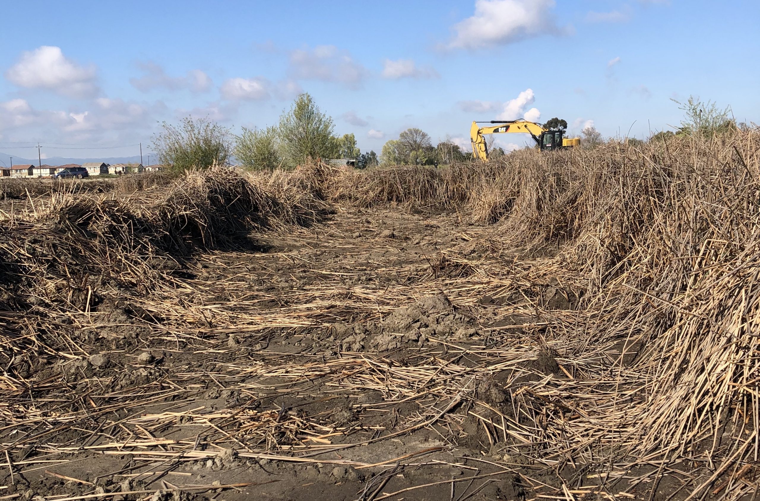
For a hawk’s-eye view of one of the Estuary’s most ambitious restoration efforts, visit the Dutch Slough Tidal Marsh Habitat Restoration Project’s YouTube channel. Drone-shot footage shows what the Department of Water Resources has been doing on 1,200 acres of former wetland, converted to pasture and subsided up to 15 feet, in the West Delta between Big Break and Jersey Island. After moving millions of cubic yards of soil to elevate the marsh plain, a team of engineers, scientists, and contractors led by project managers Katherine Bandy of DWR and Mark Lindley of Environmental Science Associates has carved channels and created a basin-and-range landscape on the Emerson and Gilbert parcels, the western two-thirds of the project site.
“We spent a lot of time studying remnants of historic tidal channel networks, looking at the sinuosity, the radius of bends,” Lindley explains. “There wasn’t much background to draw on. Then we added in topographic complexity, creating berms along the slough channels to dissipate wave energy and support a variety of plant communities.” The berms were built with onsite fill from the channel excavations.
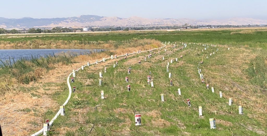
Leading the revegetation effort, DWR senior environmental scientist Molly Ferrell is growing a variety of species including California hibiscus and valley oak for upland scrub and riparian habitats and naked-stem buckwheat for remnant and restored sand dunes on the Emerson Parcel, where there’s also a working vineyard. For the marsh plain, River Partners grew tule plugs in an on-site irrigated nursery.
Revegetation work on the levee. Photo: Katherine Bandy.
“Part of trying to revegetate before breaching the levees is soil stability,” says Bandy. “We’re encouraging the tules to spread before opening the marsh to tidal action, giving it a head start. With projects further out in the Bay or inland at the right elevation, we could just open the levee and let nature take its course. Dutch Slough needed more human intervention.”
The project is on track for five levee breaches later this year, “more or less simultaneously,” Bandy adds. “It’s a bit of a dance to make sure we don’t breach ourselves into a corner.” Work on the easternmost Burroughs Parcel, delayed by uncertainty about funding and development plans for privately owned land next door, is gearing up, with groundbreaking as soon as 2022.
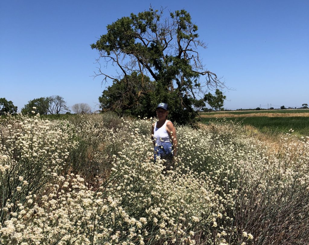
Molly Ferrell standing in excellent growth of naked-stemmed buckwheat (Eriogonum nudum var. auriculatum) flowers. The team collected the seed from Antioch Dunes National Wildlife Refuge in 2015 and seeded the dune habitat at Dutch Slough in 2017. Photo: Katherine Bandy.
Beyond restoring hydrological and ecological functions and habitat for fish, birds, and other wildlife, Dutch Slough is envisioned as a living laboratory with an adaptive management framework. “It’s designed to further increase our understanding of restoration implementation,” Bandy explains. U.S. Geological Survey researchers will study the effects of varying marsh sizes and elevations on wetland formation and carbon cycles. There will also be a recreation component, with eventual trail access linking with the East Bay Regional Park District’s trail system. Bandy, whose career involved mitigation efforts before stepping in when former project manager Patricia Finfrock retired, sees Dutch Slough as “a unique opportunity to work on a pure restoration project.” Lindley concurs: “It’s a really rewarding project. It’s amazing we’ve been able to get it all constructed.”
Joe Eaton writes about endangered and invasive species, climate and ecosystem science, environmental history, and water issues for ESTUARY. He is also "a semi-obsessive birder" whose pursuit of rarities has taken him to many of California's shores, wetlands, and sewage plants.
Our magazine’s media motto for many years has been “Where there’s an estuary, there’s a crowd.” The San Francisco Estuary is a place where people, wildlife, and commerce congregate, and where watersheds, rivers and the ocean meet and mix, creating a place of unusual diversity. In choosing to tell the...
Ever since the state and federal water projects were built in the 1930s and 1940s, California has captured snowmelt in foothill reservoirs, and moved the fresh water from dam releases and river outflows to parched parts of the state via aqueducts hundreds of miles long. A convoluted system of ancient...
Though the Clean Water Act did an amazing job of reducing wastewater and stormwater pollution of the San Francisco Estuary, some contaminants remain thorny problems. Legacy pollutants like mercury washed into the watershed from upstream gold mining, PCBs from old industrial sites, and selenium from agricultural drainage in the San...
Hothouse Earth
By Ariel Rubissow Okamoto
Photo by Megan Nguyen
Nothing could be stranger than sitting in the dark with thousands of suits and heels, watching a parade of promises to decarbonize from companies and countries large and small, reeling from the beauties of big screen rainforests and indigenous necklaces, and getting all choked up.
It was day two of the September 2018 Global Climate Action Summit in San Francisco when I felt it.
At first I wondered if I was simply starstruck. Most of us labor away trying to fix one small corner of the planet or another without seeing the likes of Harrison Ford, Al Gore, Michael Bloomberg, Van Jones, Jerry Brown – or the ministers or mayors of dozens of cities and countries – in person, on stage and at times angry enough to spit. And between these luminaries a steady stream of CEOs, corporate sustainability officers, and pension fund managers promising percentages of renewables and profits in their portfolios dedicated to the climate cause by 2020-2050.
I tried to give every speaker my full attention: the young man of Vuntut Gwichin heritage from the edge of the Yukon’s Arctic National Wildlife Refuge who pleaded with us not to enter his sacred lands with our drills and dependencies; all the women – swathed in bright patterns and head-scarfs – who kept punching their hearts. “My uncle in Uganda would take 129 years to emit the same amount of carbon as an American would in one year,” said Oxfam’s Winnie Byanyima.
“Our janitors are shutting off the lights you leave on,” said Aida Cardenas, speaking about the frontline workers she trains, mostly immigrants, who are excited to be part of climate change solutions in their new country.
The men on the stage, strutting about in feathers and pinstripes, spoke of hopes and dreams, money and power. “The notion that you can either do good or do well is a myth we have to collectively bust,” said New Jersey Governor Phil Murphy whose state is investing heavily in offshore wind farms.
“Climate change isn’t just about risks, it’s about opportunities,” said Blackrock sustainable investment manager Brian Deese.
But it wasn’t all these fine speeches that started the butterflies. Halfway through the second day of testimonials, it was a slight white-haired woman wrapped in an azure pashmina that pricked my tears. One minute she was on the silver screen with Alec Baldwin and the next she taking a seat on stage. She talked about trees. How trees can solve 30% of our carbon reduction problem. How we have to stop whacking them back in the Amazon and start planting them everywhere else. I couldn’t help thinking of Dr. Seuss and his truffala trees. Jane Goodall, over 80, is as fierce as my Lorax. Or my daughter’s Avatar.
Analyzing my take home feeling from the event I realized it wasn’t the usual fear – killer storms, tidal waves, no food for my kids to eat on a half-baked planet – nor a newfound sense of hope – I’ve always thought nature will get along just fine without us. What I felt was relief. People were actually doing something. Doing a lot. And there was so much more we could do.
As we all pumped fists in the dark, as the presentations went on and on and on because so many people and businesses and countries wanted to STEP UP, I realized how swayed I had let myself be by the doomsday news mill.
“We must be like the river, “ said a boy from Bangladesh named Risalat Khan, who had noticed our Sierra watersheds from the plane. “We must cut through the mountain of obstacles. Let’s be the river!”
Or as Harrison Ford less poetically put it: “Let’s turn off our phones and roll up our sleeves and kick this monster’s ass.”
4th California Climate Change Assessment Blues
by Isaac Pearlman
Since California’s last state-led climate change assessment in 2012, the Golden State has experienced a litany of natural disasters. This includes four years of severe drought from 2012 to 2016, an almost non-existent Sierra Nevada snowpack in 2014-2015 costing $2.1 billion in economic losses, widespread Bay Area flooding from winter 2017 storms, and extremely large and damaging wildfires culminating with this year’s Mendocino Complex fire achieving the dubious distinction of the largest in state history. California’s most recent climate assessment, released August 27th, predicts that for the state and the Bay Area, we can expect even more in the future.
The California state government first began assessing climate impacts formally in 2006, due to an executive order by Governor Schwarzenegger. California’s latest iteration and its fourth overall, includes a dizzying array of 44 technical reports; three topical studies on climate justice, tribal and indigenous communities, and the coast and ocean; as well as nine region-specific analyses.
The results are alarming for our state’s future: an estimated four to five feet of sea level rise and loss of one to two-thirds of Southern California beaches by 2100, a 50 percent increase in wildfires over 25,000 acres, stronger and longer heat waves, and infrastructure like airports, wastewater treatment plants, rail and roadways increasingly likely to suffer flooding.
For the first time, California’s latest assessment dives into climate consequences on a regional level. Academics representing nine California regions spearheaded research and summarized the best available science on the variable heat, rain, flooding and extreme event consequences for their areas. For example, the highest local rate of sea level rise in the state is at the rapidly subsiding Humboldt Bay. In San Diego county, the most biodiverse in all of California, preserving its many fragile and endangered species is an urgent priority. Francesca Hopkins from UC Riverside found that the highest rate of childhood asthma in the state isn’t an urban smog-filled city but in the Imperial Valley, where toxic dust from Salton Sea disaster chokes communities – and will only become worse as higher temperatures and less water due to climate change dry and brittle the area.
According to the Bay Area Regional Report, since 1950 the Bay Area has already increased in temperature by 1.7 degrees Fahrenheit and local sea level is eight inches higher than it was one hundred years ago. Future climate will render the Bay Area less suitable for our evergreen redwood and fir forests, and more favorable for tolerant chaparral shrub land. The region’s seven million people and $750 billion economy (almost one-third of California’s total) is predicted to be increasingly beset by more “boom and bust” irregular wet and very dry years, punctuated by increasingly intense and damaging storms.
Unsurprisingly, according to the report the Bay Area’s intensifying housing and equity problems have a multiplier affect with climate change. As Bay Area housing spreads further north, south, and inland the result is higher transportation and energy needs for those with the fewest resources available to afford them; and acute disparity in climate vulnerability across Bay Area communities and populations.
“All Californians will likely endure more illness and be at greater risk of early death because of climate change,” bluntly states the statewide summary brochure for California’s climate assessment. “[However] vulnerable populations that already experience the greatest adverse health impacts will be disproportionately affected.”
“We’re much better at being reactive to a disaster than planning ahead,” said UC Berkeley professor and contributing author David Ackerly at a California Adaptation Forum panel in Sacramento on August 27th. “And it is vulnerable communities that suffer from those disasters. How much human suffering has to happen before it triggers the next round of activity?”
The assessment’s data is publicly available online at “Cal-adapt,” where Californians can explore projected impacts for their neighborhoods, towns, and regions.


 The results are alarming for our state’s future: an estimated four to five feet of sea level rise and loss of one to two-thirds of Southern California beaches by 2100, a 50 percent increase in wildfires over 25,000 acres, stronger and longer heat waves, and infrastructure like airports, wastewater treatment plants, rail and roadways increasingly likely to suffer flooding.