The 1960s and ‘70s were a time of rapid change for the San Francisco Bay shoreline. It had long been treated as a waste disposal site or area to fill for development, but public outcry for protection reached a crescendo in 1969 with the birth of the San Francisco Bay Conservation and Development Commission (BCDC). The passage of the federal Clean Water Act in 1972 meant that destruction of wetland habitat—already 90% vanished from the Bay—had to be mitigated, or re-created elsewhere. For the first time there was public support and a legal obligation to restore wetlands, but scientists had to figure out how.
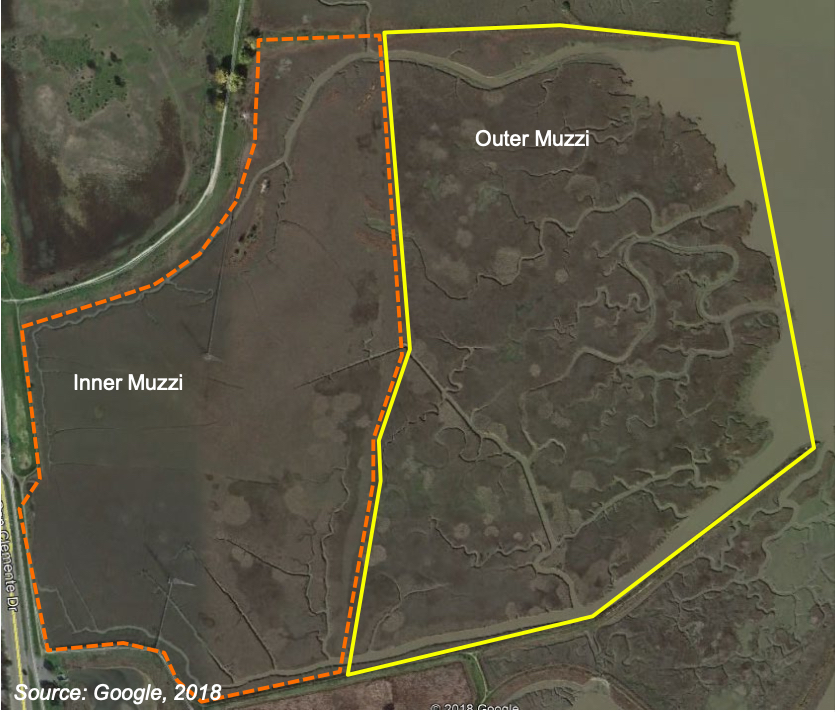
On June 3, 1976, an intrepid group of restorationists in the small Marin County town of Corte Madera kicked off one of the biggest and boldest restoration experiments undertaken in the Bay Area to date: returning 128 acres of sunken land to the tidal embrace of the San Francisco Bay. Their working materials included a large pile of thick mud leftover from the creation of the nearby Larkspur Ferry Terminal, a field that had been diked off for agriculture and development decades ago by Domenic Muzzi, and the unproven hope that the Bay’s nutrient-rich waters would do most of the heavy lifting by allowing marsh vegetation to naturally establish.
“Restoration projects had very targeted and simplistic objectives back then,” says Stuart Siegel, who cut his teeth on the restoration of Hoffman Marsh in Richmond during the mid-1980s. Siegel, who today is a San Francisco State University research professor and interim director of the San Francisco Bay National Estuarine Research Reserve, says the early days were simply about trying things to see what happened. “The restoration goals really were: are tides reaching the restored area, are you seeing the right vegetation, and are birds coming back?”
Just a few years prior to the attempt to bring back Muzzi Marsh, it was widely believed that a tidal salt marsh could never be restored. Now, restorationists led by the legendary wetland biologist and recently departed Phyllis Faber were in the midst of “uncharted territory” as she later called the fledgling Muzzi Marsh experiment in a 2015 interview.
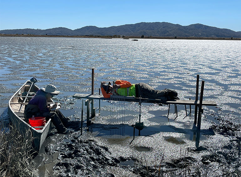
In those early days there were no wetland design criteria, restoration science, or success metrics to draw from. Nor even the most basic data: in the book Natural History of the San Francisco Bay, early restoration pioneer Phil Williams recalls organizing shifts of volunteers to note the tidal height on measuring sticks stuck in the mud every 15 minutes—for 30 hours straight. No simple equipment existed to measure water velocity, so field researchers often deployed the “Luna Leopold” method of planting two stakes a known distance along the water and then tossing in orange peels to measure the current speed.
This trial-and-error beginning to tidal restoration meant that early projects were educational laboratories. The expectation at the time was the Muzzi project would quickly develop into a mature, vegetated marsh. But restorationists learned from their first attempt that simply leveling the site to the high tide height didn’t produce enough tidal flow over restored areas, which in turn created low plant survival. As a consequence, Muzzi’s inner site failed to develop the same channel and topographic complexity that the outer marsh formed on its own from the tides, and later restoration work excavated more channels in order to extend the Bay’s reach inland.
Muzzi Marsh site map. Image: ESA
Some lessons were as simple as learning how to work in viscous mud. “You’re not a salt marsh ecologist unless you’ve left behind a boot or three,” laughs Donna Ball, senior scientist with the San Francisco Estuary Institute and 20-year wetland restoration veteran.
Siegel admits to having “donated” many boots to the marsh during his early years. Nowadays hip and chest waders are standard gear, with Siegel’s SFSU colleague Katharyn Boyer improvising use of wetsuits and boogie boards to stay above the muck—though getting stuck is still a timeless initiation to wetland work.
Some of the early restoration sites never panned out: Warm Springs Marsh in the South Bay was restored in 1986, but according to Siegel is still unvegetated mudflat today. Similarly, a site in Richmond called the Nevada Parcel due to its shape, never evolved into tidal wetland.
Muzzi Marsh, however, is now part of the Corte Madera Marsh Ecological Reserve, where raptors soar overhead, shorebirds bob beaks into soft Bay mud, and salt marsh harvest mice hide out under extensive pickleweed. The wetland is home to the one of the Bay’s largest populations of endangered Ridgway’s rail. Muzzi Marsh is now among the most studied restoration sites in the Bay that—to the delight of the countless folks who have contributed to, and learned from, one of the longest restoration monitoring datasets in the San Francisco Bay—is still evolving today.
A regional view of restoration
In 1987, a new amendment to the Clean Water Act forced municipalities to regulate polluted storm runoff, resulting in greatly reduced Bay contamination. Though several large oil spills still muddied the waters…and marshes. In this era, tidal restoration mostly driven by required mitigation was picking up steam: by 1998 about 4,000 acres of tidal wetland had been restored to the San Francisco Bay. New projects now had restoration data and science to guide them—but there were still plenty of lessons to learn.
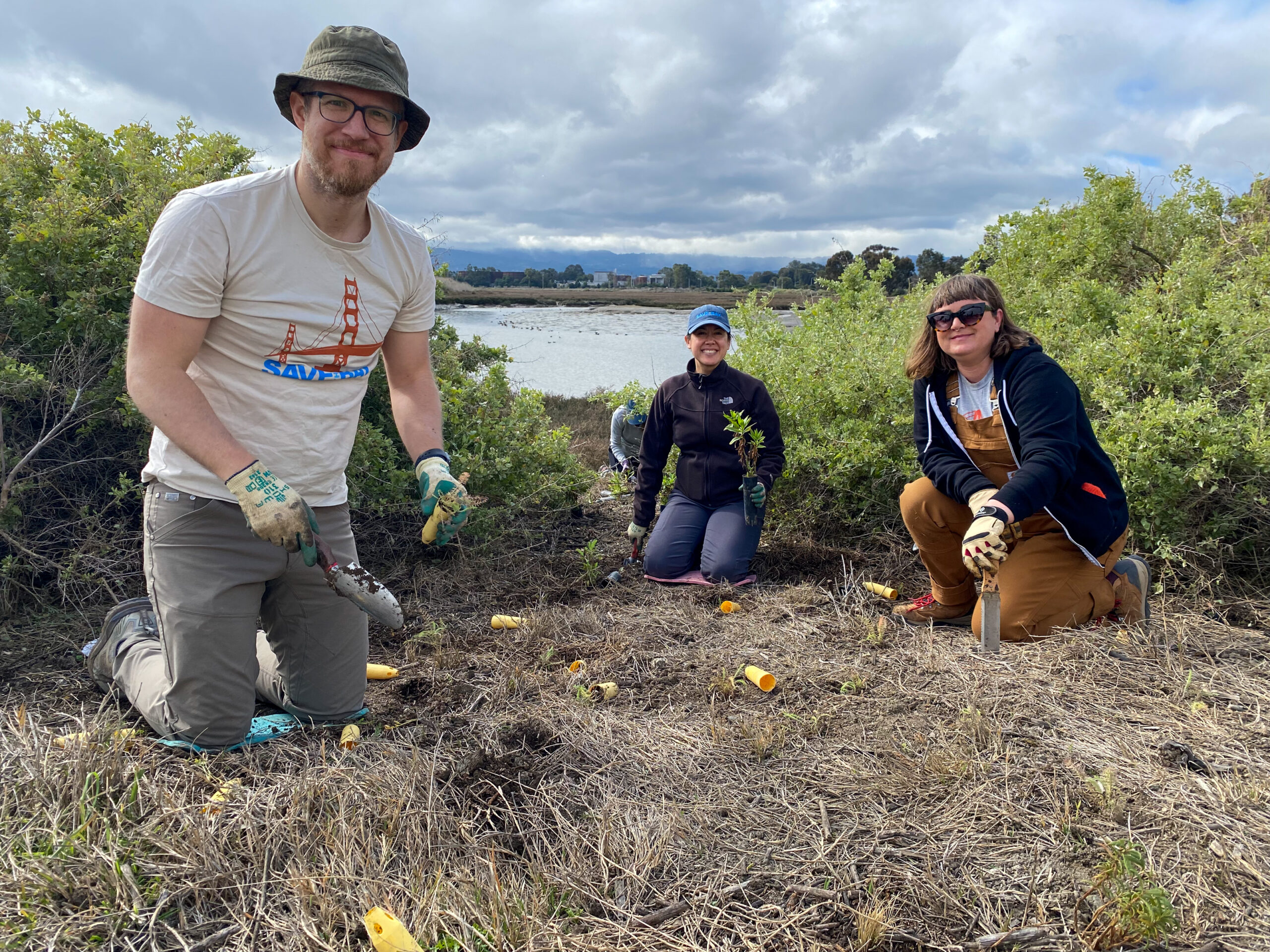
The activist organization Save the Bay grew out of early efforts in the 1970s to clean up contamination and save species, and continues its work to this day. Photo: Save the Bay
In July 1994, the Sonoma Baylands wetland restoration officially kicked off with a ceremony attended by then-Vice President Al Gore. The 300-acre project, subject to a White House task force and endorsement from Bill Clinton, was opened to the tides in October 1996 when Bay water rushed into land it hadn’t touched for nearly 100 years.
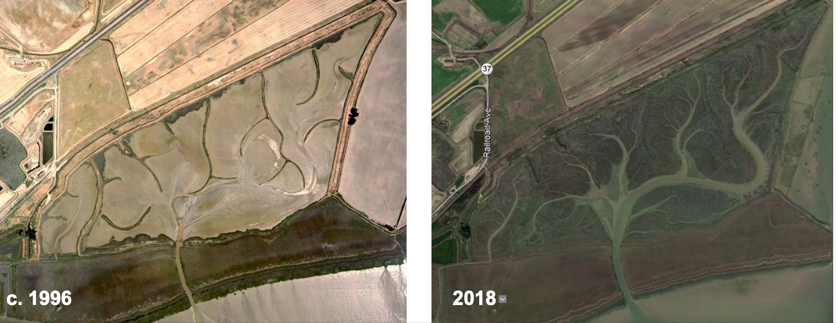
Unlike the restoration of Muzzi Marsh 20 years prior, restorationists opted to deliberately underfill the Sonoma Baylands site with dredged sediment, leaving it 18 inches below the high-tide mark. This would allow the Bay’s nourishing water to wash over the area like a balming salve, dropping fine sediment and naturally grooving sinuous channels on the tide’s way out. As one of the first restoration projects to formally incorporate available monitoring data into its design, the Sonoma Baylands effort marked a shift to “second-generation” projects built off 20 years of hard-earned marsh restoration knowledge. It also represented a regulations breakthrough in providing a home for sediment from the Oakland Harbor, as dredging had been stymied for years by a lack of spoil disposal options.
Both the Sonoma Baylands and the 1999 restoration of San Francisco’s Crissy Field also featured a new design element: deliberately piled “islands” of sediment in the middle of future marshland, which created nesting habitat for birds but came with the additional benefit of buffering the area against wind and waves. In addition, the Crissy Field project pioneered a different type of innovation: human resources. Thousands of community volunteers contributed labor to help restore the dunes and marsh, and enthusiastically participated in more than 100 public meetings. As a result, with its elevated boardwalk and perimeter paths, the project was one of the first to integrate public access with sensitive habitat restoration. (See Bay Trail story).
“I came to the Bay Area restoration community from a small town in Washington State,” says Ball. “It surprised me when I arrived how much support there was for restoration in an urban area like the San Francisco Bay.”
Sonoma Baylands evolves. Image: ESA
As these second-generation restoration projects matured, they uncovered more lessons for scientists. Sonoma Baylands was limited by its existing small Bay channel, which restricted the amount of alimentary tidal flow to the inland restoration area and created more mudflat than marsh vegetation. As a consequence it took over a decade longer to develop marsh habitat than expected, though eventually a beautiful dendritic marsh plain did form.Crissy Field, with its complicated and shifting beach shoal, became more of a lagoon than wetland requiring periodic dredging and maintenance rather than the tidal flushing initially imagined.
Reinforcing those lessons was the growing field of wetland science. Data from National Oceanic and Atmospheric Administration buoys and its network of tidal stations meant that manually measuring water height wasn’t needed any more. Water-quality monitoring in the Bay expanded its scope to include pollutant impacts in wetlands, and started to uncover the habitat’s key role as a natural contaminant filter.
In the 1990s maps of the San Francisco Bay, which had mostly ignored marshes and Baylands except for navigation purposes, began to reflect satellite radar, infrared, and other spectral imaging that for the first time revealed in richly intricate detail the complex and dynamic boundary between the land and Bay. As environmental science and monitoring data proliferated like an algal bloom, restoration projects began to attract biologists, geomorphologists, coastal engineers, hydrologists, and other specialized experts.
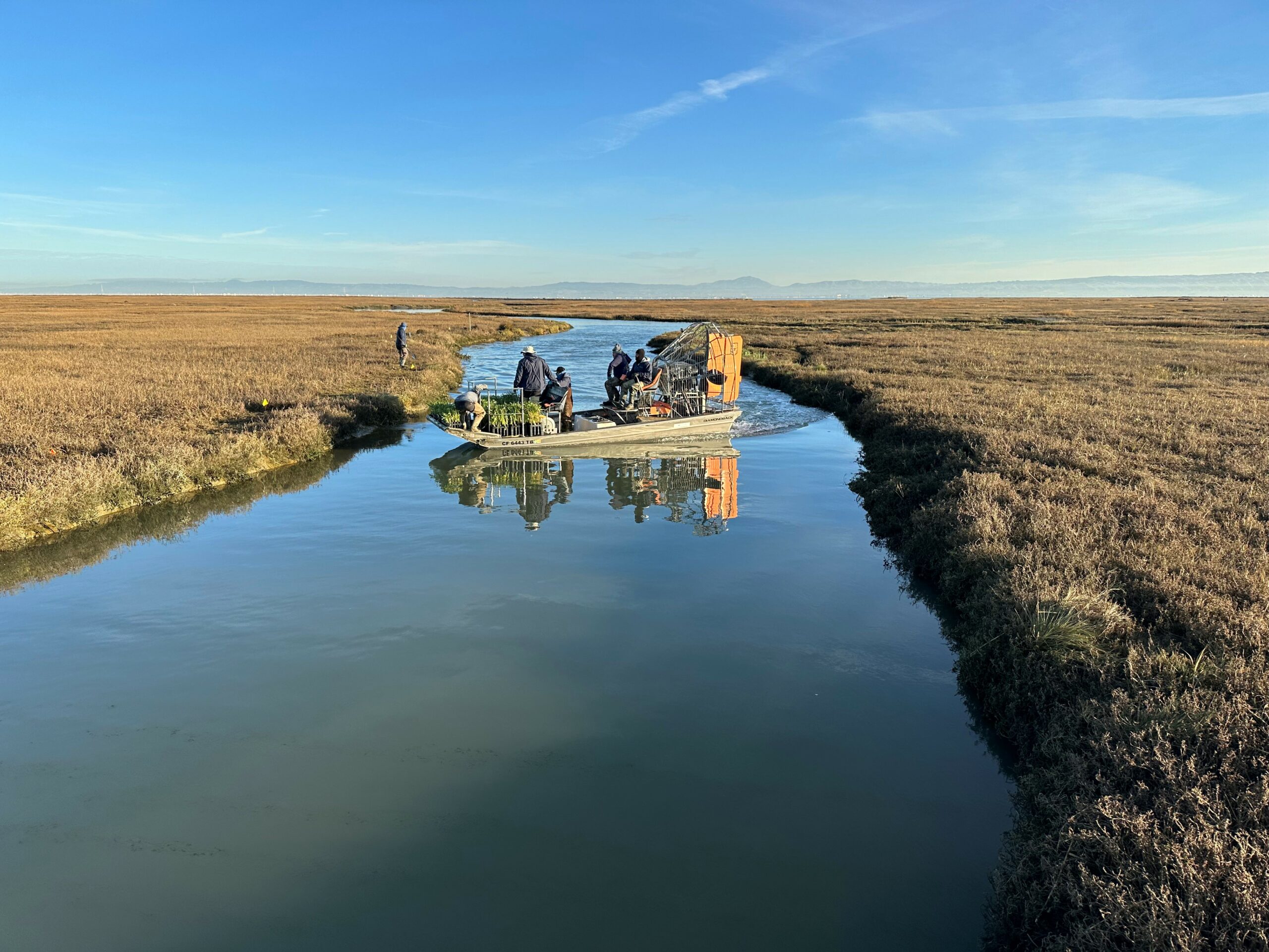
Satellites, GPS and use of airboats help restoration crews target native ecotone plantings in hard to access interior wetland sites. Photo: Simon Gunner
“We now work together a lot more now than we did in the past,” says Ball, remarking how satellite imagery and data on parameters from marsh elevation to sediment supply are just a collaborative phone call away. “Early salt marsh work involved people out there with measuring sticks. Technology now helps us a lot—for example, we can now learn a lot more detail about [marsh] systems through remote sensing.”
In spite of all the progress, a 1999 comprehensive review of San Francisco Bayland ecosystems concluded that “the science of wetland restoration is still in its infancy.” Critical questions like “what does wetland restoration success actually look like?” were still open for debate. Although restorationists ushered in rapid advances in wetland research and data, the community wasn’t always able to benefit. In this era before widespread internet use, a significant amount of monitoring reports, data, and key studies remained tucked away from public view in the dusty record-room cabinets and bookshelves of agencies.
As data expanded our view of wetlands, it also began to offer a tantalizing glimpse of the Bay as a whole. In the late ‘90s, the Bay Area’s top 100 scientists and regulators convened to identify 120 species to serve as proxies for Bayland ecosystem health, and then debated how much habitat was needed to support these species. After three years of discourse the team delivered the San Francisco Bay’s first regionwide restoration goal in 1999, one that 20 years before would have seemed fantastical to those early Muzzi Marsh trailblazers: 100,000 total acres of tidal wetlands—nearly half of what had been lost to 150 years of human development.
Supersized restoration in an era of climate change
With the purchase of the 10,000-acre Napa River Salt Ponds using oil spill mitigation funds, the restoration community began to shift its focus from individual “postage-stamp” mitigation projects to the idea of large-scale restoration. Since the year 2000, restoration efforts have rapidly jumped up in size, complexity, and ambition, with projects like Hamilton Airfield (648 acres), Sears Point (960 acres), Bel Marin Keys (1,900 acres), Montezuma (2,300 acres), and the South Bay Salt Ponds (15,100 acres). With this came a recognition of the massive benefits of restoring landscape-scale ecological functions, though those benefits came with new challenges—not the least of which include looming climate change.
Montezuma Wetlands project in 2021. Photo: Darren Graffuis
In early 2006 an excavator near Alviso, San Jose’s waterfront district, dug a narrow trench to breach the blandly named Pond A19, reconnecting 800 acres of former industrial salt ponds back to the Bay. The broken berm ushered in the tides, and with it one of the largest tidal restoration projects ever undertaken: a 50-year reestablishment of wetlands across an area half the size of San Francisco. “The scale really amazes me now,” says Siegel. “In the 1970s and ‘80s, restoration projects were little things. Today the larger scale has really changed what can be accomplished.”
In addition to their size, these “third-generation” projects have taken a more holistic view, recognizing the importance of including upland transition zones and subtidal habitats in wetland restoration, instead of focusing only on marsh. Incorporating habitat features like oyster beds and eelgrass for wave attenuation into flood infrastructure, and water filtration and marsh mounds into habitat restoration, has given rise to multi-benefit projects that blur the boundary between nature and infrastructure. In a sign of how far things have come, the United States Army Corps of Engineers—a historically habitat-averse agency—is using one million cubic yards of sediment to build diverse wetland habitats on the sloped bayside of the 3.8-mile, 15-foot-high levee protecting Alviso and San Jose from tidal waters once the adjacent salt ponds are breached.
As the scale of projects has increased, so too has the available science and analytics. Now there are streams of satellite and drone data to monitor everything from salinity and elevation to vegetation cover and species observation. The South Bay Salt Pond Restoration Project has a full-fledged science program tracking 26 indicators ranging from breeding success of avocets and harbor seals to public access and water quality. The project is mapping habitat evolution from space at a half-meter resolution. There is now a new Bay-wide wetland monitoring program specifically focused on assessing restoration progress on a larger scale.
Nowadays restorationists have the online-dating-inspired SediMatch tool to connect dredge sediment donors with matching restoration project recipients. They can capture ambient DNA molecules from a scoop of water to determine presence of the most cryptic species. A glance at the last Bay-Delta Science Conference shows researchers using artificial intelligence to inform Bay-wide water flow models, carbon and nitrogen isotope analysis in sandpipers, and a pilot attempt to create floating wetlands.
High tech tools are no substitute for the many people involved in hands-on restoration by organizations like Save the Bay, building an informed community around a healthy Bay. Photo: Save the Bay.
This flood of data, tools, and knowledge is critically important as climate change challenges wetland restoration to continue evolving. For example, sea-level rise means those hard-earned lessons of under-filling restoration sites may not apply anymore, and banking “elevation capital” is needed in some areas to help habitat keep pace with rising waters. Instead of a hard target for acres of marsh habitat restored, the South Bay Salt Pond Restoration Project developed a 143-page, 50-year adaptation plan for how to monitor and iterate data into management decision-trees as the restoration, and climate change, unfold (see related story).
“I’m most excited about collaborating with other scientists working on the shared goal of tackling the climate change issues ahead of us,” says Ball, who is working on the regional wetland monitoring initiative. “Technology will continue to advance—and I think we are ready to embrace it.”
It’s been a long journey since the era of orange peels and sticks in the mud. We’ve added nearly 18,000 acres of wetlands to the some 40,000 acres of remnant marsh that were protected from development. With tens of thousands more acres in the restoration pipeline, we are inching closer to that once-inconceivable goal of 100,000 acres of wetlands. Perhaps even more impressive than the scientific advancement is the funding landscape: today there are multiple federal and state pots for wetland restoration, and dedicated Measure AA funding available after years of tireless advocacy by Bay conservation groups.
Almost 45 years after the Muzzi Marsh experiment, the wetland restoration community is now flush with funding and public support, and spurred on by exciting advancements in restoration science and small but important steps by regulatory agencies to speed up project permitting. By any measure, it appears the wetland restoration community is no longer stuck in the mud.
Top Photo: Measuring sediment accretion and Hamilton wetlands restoration site in Marin County. Photo: ESA
Isaac Pearlman covers sea level rise, flooding, and other topics for ESTUARY. A Bay Area native, Isaac's writing is informed by his master's degree in environmental science, as well as many adventures from living and working in South America, Europe, and Southeast Asia. His stories and essays have been featured in Earth Island Journal, the Progressive Populist, and Ecosystems among other outlets. https://isaacpearlman.wordpress.com
Our magazine’s media motto for many years has been “Where there’s an estuary, there’s a crowd.” The San Francisco Estuary is a place where people, wildlife, and commerce congregate, and where watersheds, rivers and the ocean meet and mix, creating a place of unusual diversity. In choosing to tell the...
Ever since the state and federal water projects were built in the 1930s and 1940s, California has captured snowmelt in foothill reservoirs, and moved the fresh water from dam releases and river outflows to parched parts of the state via aqueducts hundreds of miles long. A convoluted system of ancient...
Though the Clean Water Act did an amazing job of reducing wastewater and stormwater pollution of the San Francisco Estuary, some contaminants remain thorny problems. Legacy pollutants like mercury washed into the watershed from upstream gold mining, PCBs from old industrial sites, and selenium from agricultural drainage in the San...
Hothouse Earth
By Ariel Rubissow Okamoto
Photo by Megan Nguyen
Nothing could be stranger than sitting in the dark with thousands of suits and heels, watching a parade of promises to decarbonize from companies and countries large and small, reeling from the beauties of big screen rainforests and indigenous necklaces, and getting all choked up.
It was day two of the September 2018 Global Climate Action Summit in San Francisco when I felt it.
At first I wondered if I was simply starstruck. Most of us labor away trying to fix one small corner of the planet or another without seeing the likes of Harrison Ford, Al Gore, Michael Bloomberg, Van Jones, Jerry Brown – or the ministers or mayors of dozens of cities and countries – in person, on stage and at times angry enough to spit. And between these luminaries a steady stream of CEOs, corporate sustainability officers, and pension fund managers promising percentages of renewables and profits in their portfolios dedicated to the climate cause by 2020-2050.
I tried to give every speaker my full attention: the young man of Vuntut Gwichin heritage from the edge of the Yukon’s Arctic National Wildlife Refuge who pleaded with us not to enter his sacred lands with our drills and dependencies; all the women – swathed in bright patterns and head-scarfs – who kept punching their hearts. “My uncle in Uganda would take 129 years to emit the same amount of carbon as an American would in one year,” said Oxfam’s Winnie Byanyima.
“Our janitors are shutting off the lights you leave on,” said Aida Cardenas, speaking about the frontline workers she trains, mostly immigrants, who are excited to be part of climate change solutions in their new country.
The men on the stage, strutting about in feathers and pinstripes, spoke of hopes and dreams, money and power. “The notion that you can either do good or do well is a myth we have to collectively bust,” said New Jersey Governor Phil Murphy whose state is investing heavily in offshore wind farms.
“Climate change isn’t just about risks, it’s about opportunities,” said Blackrock sustainable investment manager Brian Deese.
But it wasn’t all these fine speeches that started the butterflies. Halfway through the second day of testimonials, it was a slight white-haired woman wrapped in an azure pashmina that pricked my tears. One minute she was on the silver screen with Alec Baldwin and the next she taking a seat on stage. She talked about trees. How trees can solve 30% of our carbon reduction problem. How we have to stop whacking them back in the Amazon and start planting them everywhere else. I couldn’t help thinking of Dr. Seuss and his truffala trees. Jane Goodall, over 80, is as fierce as my Lorax. Or my daughter’s Avatar.
Analyzing my take home feeling from the event I realized it wasn’t the usual fear – killer storms, tidal waves, no food for my kids to eat on a half-baked planet – nor a newfound sense of hope – I’ve always thought nature will get along just fine without us. What I felt was relief. People were actually doing something. Doing a lot. And there was so much more we could do.
As we all pumped fists in the dark, as the presentations went on and on and on because so many people and businesses and countries wanted to STEP UP, I realized how swayed I had let myself be by the doomsday news mill.
“We must be like the river, “ said a boy from Bangladesh named Risalat Khan, who had noticed our Sierra watersheds from the plane. “We must cut through the mountain of obstacles. Let’s be the river!”
Or as Harrison Ford less poetically put it: “Let’s turn off our phones and roll up our sleeves and kick this monster’s ass.”
4th California Climate Change Assessment Blues
by Isaac Pearlman
Since California’s last state-led climate change assessment in 2012, the Golden State has experienced a litany of natural disasters. This includes four years of severe drought from 2012 to 2016, an almost non-existent Sierra Nevada snowpack in 2014-2015 costing $2.1 billion in economic losses, widespread Bay Area flooding from winter 2017 storms, and extremely large and damaging wildfires culminating with this year’s Mendocino Complex fire achieving the dubious distinction of the largest in state history. California’s most recent climate assessment, released August 27th, predicts that for the state and the Bay Area, we can expect even more in the future.
The California state government first began assessing climate impacts formally in 2006, due to an executive order by Governor Schwarzenegger. California’s latest iteration and its fourth overall, includes a dizzying array of 44 technical reports; three topical studies on climate justice, tribal and indigenous communities, and the coast and ocean; as well as nine region-specific analyses.
The results are alarming for our state’s future: an estimated four to five feet of sea level rise and loss of one to two-thirds of Southern California beaches by 2100, a 50 percent increase in wildfires over 25,000 acres, stronger and longer heat waves, and infrastructure like airports, wastewater treatment plants, rail and roadways increasingly likely to suffer flooding.
For the first time, California’s latest assessment dives into climate consequences on a regional level. Academics representing nine California regions spearheaded research and summarized the best available science on the variable heat, rain, flooding and extreme event consequences for their areas. For example, the highest local rate of sea level rise in the state is at the rapidly subsiding Humboldt Bay. In San Diego county, the most biodiverse in all of California, preserving its many fragile and endangered species is an urgent priority. Francesca Hopkins from UC Riverside found that the highest rate of childhood asthma in the state isn’t an urban smog-filled city but in the Imperial Valley, where toxic dust from Salton Sea disaster chokes communities – and will only become worse as higher temperatures and less water due to climate change dry and brittle the area.
According to the Bay Area Regional Report, since 1950 the Bay Area has already increased in temperature by 1.7 degrees Fahrenheit and local sea level is eight inches higher than it was one hundred years ago. Future climate will render the Bay Area less suitable for our evergreen redwood and fir forests, and more favorable for tolerant chaparral shrub land. The region’s seven million people and $750 billion economy (almost one-third of California’s total) is predicted to be increasingly beset by more “boom and bust” irregular wet and very dry years, punctuated by increasingly intense and damaging storms.
Unsurprisingly, according to the report the Bay Area’s intensifying housing and equity problems have a multiplier affect with climate change. As Bay Area housing spreads further north, south, and inland the result is higher transportation and energy needs for those with the fewest resources available to afford them; and acute disparity in climate vulnerability across Bay Area communities and populations.
“All Californians will likely endure more illness and be at greater risk of early death because of climate change,” bluntly states the statewide summary brochure for California’s climate assessment. “[However] vulnerable populations that already experience the greatest adverse health impacts will be disproportionately affected.”
“We’re much better at being reactive to a disaster than planning ahead,” said UC Berkeley professor and contributing author David Ackerly at a California Adaptation Forum panel in Sacramento on August 27th. “And it is vulnerable communities that suffer from those disasters. How much human suffering has to happen before it triggers the next round of activity?”
The assessment’s data is publicly available online at “Cal-adapt,” where Californians can explore projected impacts for their neighborhoods, towns, and regions.


 The results are alarming for our state’s future: an estimated four to five feet of sea level rise and loss of one to two-thirds of Southern California beaches by 2100, a 50 percent increase in wildfires over 25,000 acres, stronger and longer heat waves, and infrastructure like airports, wastewater treatment plants, rail and roadways increasingly likely to suffer flooding.