Imagine a complex of tidal wetlands skirting San Pablo Bay unbroken from China Camp to Mare Island, providing vital wildlife habitat and protecting inland communities from storm surge and sea-level rise. With stretches of this shoreline formerly diked and drained (or in Hamilton Wetlands’ case, converted to a military airfield), reconnecting it may have once seemed unlikely. Yet today just two gaps remain, one of which is included in a restoration project that’s already underway: Bel Marin Keys. And it’s a doozy.
The problem is one of scope—and more specifically of mud. The project site, currently partitioned into fields for agricultural use by a grid of berms and drainage ditches, is so large (1,900 acres), and the land so subsided that breaching its Bay-fronting concrete-and-riprap levee would flood much of the property, berms included, with multiple feet of saltwater.
Hence the need for mud: initial designs called for about 14 million cubic yards of it, to raise the elevation sufficiently to allow for the formation of new tidal marsh and transition zone habitat. That’s a huge amount of sediment, the equivalent of roughly a million large dump truck loads—or 14 years’ worth of dredged material from the Port of Oakland, which in the late 2000s provided 3.5 million cubic yards to the Hamilton Wetlands Restoration Project immediately south of Bel Marin Keys.
Without more mud, the project can’t be completed. Numerous potential sources exist, but none have yet to be secured. And given a limited (and declining) supply of sediment in the Bay system, with other restoration sites like Montezuma Wetlands in Suisun and Cullinan Ranch on the north side of Highway 37 also in need, it’s a zero-sum game with no easy answers.
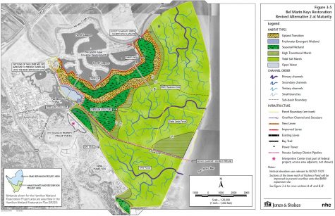
Preliminary, rough schematic of a restored Bel Marin Keys (with the already-completed Hamilton Wetlands to the south); exact details and design elements have yet to be finalized. Courtesy State Coastal Conservancy.
“It really becomes this challenge of, ‘Where does the sediment come from and how do we get it there?’” says Julie Beagle, an environmental planning section chief with the US Army Corps of Engineers and expert on the use of dredged sediment for marsh restoration.
The reality is that it’s looking increasingly likely the project must make do with less than the full 14 million cubic yards, says Jessica Davenport, a project lead with the California State Coastal Conservancy. “The Corps and the Conservancy will be exploring ways to construct the project with a smaller volume of dredged material,” she says. “Filling the site to capacity…is looking impractical. We will be considering how to make the best use of a smaller volume of imported sediment, with the exact amount still to be determined.”
Not only that, but the source—and delivery method—of the mud still must be settled. Project planners are considering a host of approaches for Bel Marin Keys, some informed by past restoration projects on San Pablo Bay, Davenport says. These include running a pipe across the site to deliver sediment from dredge projects, as was done at Hamilton; building habitat islands from available material, then opening the site and letting it naturally accrete at a slower pace, as was done at Sears Point (which sits next door to the other remaining gap in San Pablo Bay marsh, Tubbs Island); and dividing the site into cells for a phased or multi-method approach, as at Cullinan Ranch.
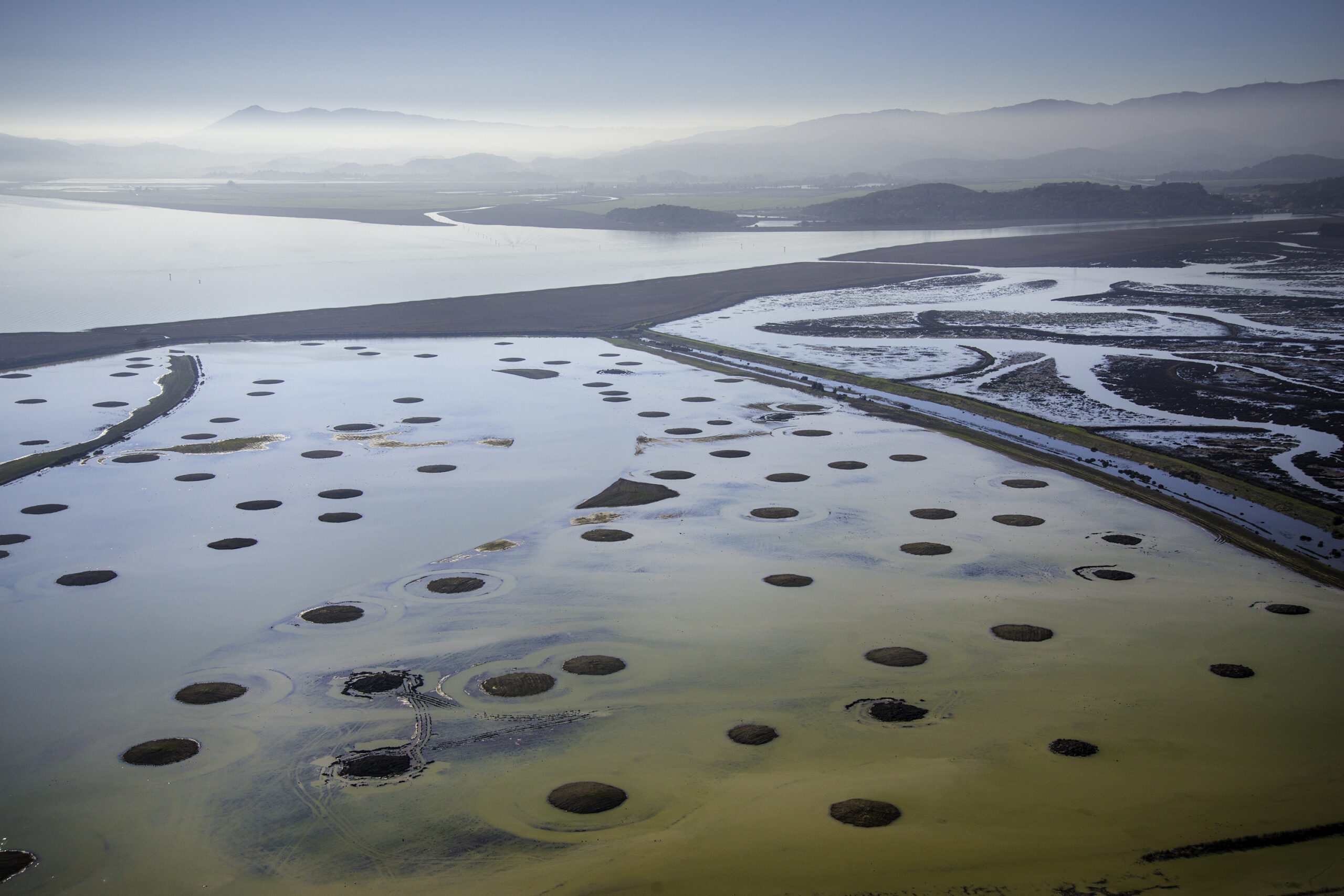
Islands at Sear’s Point. Photo: Sonoma Land Trust
Other ideas being explored include drawing sediment from and subsequently refilling an “aquatic transfer facility” on the Bay floor, and connecting the site to Novato Creek for sediment delivery, Beagle notes.
Add another question to the list: How long will all this take? “If it takes 20 years to do a project, and we know 2030 is this magic time where marshes need to be in place in order to keep pace with sea-level rise, which is what the Baylands Goals told us ….” Well, that’s not ideal. “We want to get these projects done,” she says. The “landscape-scale” size of Bel Marin Keys, and its connectivity to a restored Hamilton next door, make its impact, and urgency, all the greater.
Some critical work has already been completed. A new outboard levee built in 2021, about a mile landward of the existing levee fronting San Pablo Bay, snakes its way from north to south just in front of the Bel Marin Keys housing development. Behind it, new seasonal wetlands and alkali meadows have been constructed. But between it and the open Bay to the east lie acres upon acres of subsided agricultural fields that must be dealt with before the water can be allowed to rush back in.
To help move the project along, the Conservancy recently contracted with an engineering consultant that will lead a series of design charrettes, Davenport says. In addition to evaluating concepts generated through that process, “the Corps will conduct value engineering, a review process that will seek ways to reduce cost while still delivering the desired ecological functions,” she adds.
A tentative schedule outlined by the Corps anticipates that plans and permits will be complete by 2026 and a construction contract awarded by 2027. Sediment placement should take place over the ensuing decade, with the big moment—the levee breach—finally occurring around 2037.
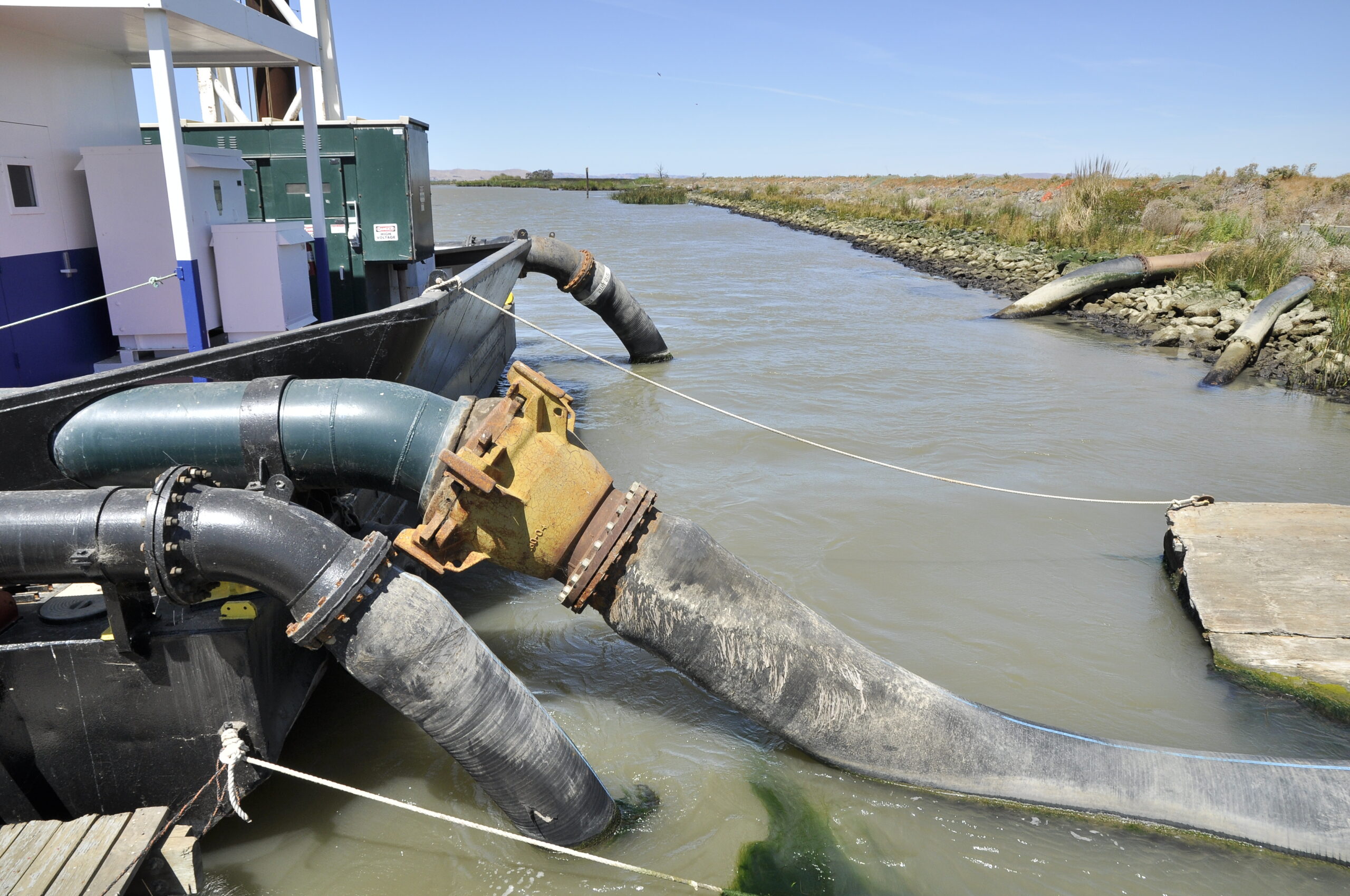
Top Photo: Techniques used to add sediment to the Montezuma Wetlands included hosing it from a sediment laden barge. Photo: Darren Graffuis
Nate Seltenrich is a freelance science and environmental journalist who covers infrastructure, restoration, and related topics for Estuary. He also contributes to the San Francisco Chronicle, Sonoma and Marin magazines, the journal Environmental Health Perspectives, and other local and national publications, on subjects ranging from public lands and renewable energy to the human health impacts of climate change. He lives in Petaluma with his wife, two boys, and four ducks. www.nate-reports.com
Our magazine’s media motto for many years has been “Where there’s an estuary, there’s a crowd.” The San Francisco Estuary is a place where people, wildlife, and commerce congregate, and where watersheds, rivers and the ocean meet and mix, creating a place of unusual diversity. In choosing to tell the...
Ever since the state and federal water projects were built in the 1930s and 1940s, California has captured snowmelt in foothill reservoirs, and moved the fresh water from dam releases and river outflows to parched parts of the state via aqueducts hundreds of miles long. A convoluted system of ancient...
Though the Clean Water Act did an amazing job of reducing wastewater and stormwater pollution of the San Francisco Estuary, some contaminants remain thorny problems. Legacy pollutants like mercury washed into the watershed from upstream gold mining, PCBs from old industrial sites, and selenium from agricultural drainage in the San...
Hothouse Earth
By Ariel Rubissow Okamoto
Photo by Megan Nguyen
Nothing could be stranger than sitting in the dark with thousands of suits and heels, watching a parade of promises to decarbonize from companies and countries large and small, reeling from the beauties of big screen rainforests and indigenous necklaces, and getting all choked up.
It was day two of the September 2018 Global Climate Action Summit in San Francisco when I felt it.
At first I wondered if I was simply starstruck. Most of us labor away trying to fix one small corner of the planet or another without seeing the likes of Harrison Ford, Al Gore, Michael Bloomberg, Van Jones, Jerry Brown – or the ministers or mayors of dozens of cities and countries – in person, on stage and at times angry enough to spit. And between these luminaries a steady stream of CEOs, corporate sustainability officers, and pension fund managers promising percentages of renewables and profits in their portfolios dedicated to the climate cause by 2020-2050.
I tried to give every speaker my full attention: the young man of Vuntut Gwichin heritage from the edge of the Yukon’s Arctic National Wildlife Refuge who pleaded with us not to enter his sacred lands with our drills and dependencies; all the women – swathed in bright patterns and head-scarfs – who kept punching their hearts. “My uncle in Uganda would take 129 years to emit the same amount of carbon as an American would in one year,” said Oxfam’s Winnie Byanyima.
“Our janitors are shutting off the lights you leave on,” said Aida Cardenas, speaking about the frontline workers she trains, mostly immigrants, who are excited to be part of climate change solutions in their new country.
The men on the stage, strutting about in feathers and pinstripes, spoke of hopes and dreams, money and power. “The notion that you can either do good or do well is a myth we have to collectively bust,” said New Jersey Governor Phil Murphy whose state is investing heavily in offshore wind farms.
“Climate change isn’t just about risks, it’s about opportunities,” said Blackrock sustainable investment manager Brian Deese.
But it wasn’t all these fine speeches that started the butterflies. Halfway through the second day of testimonials, it was a slight white-haired woman wrapped in an azure pashmina that pricked my tears. One minute she was on the silver screen with Alec Baldwin and the next she taking a seat on stage. She talked about trees. How trees can solve 30% of our carbon reduction problem. How we have to stop whacking them back in the Amazon and start planting them everywhere else. I couldn’t help thinking of Dr. Seuss and his truffala trees. Jane Goodall, over 80, is as fierce as my Lorax. Or my daughter’s Avatar.
Analyzing my take home feeling from the event I realized it wasn’t the usual fear – killer storms, tidal waves, no food for my kids to eat on a half-baked planet – nor a newfound sense of hope – I’ve always thought nature will get along just fine without us. What I felt was relief. People were actually doing something. Doing a lot. And there was so much more we could do.
As we all pumped fists in the dark, as the presentations went on and on and on because so many people and businesses and countries wanted to STEP UP, I realized how swayed I had let myself be by the doomsday news mill.
“We must be like the river, “ said a boy from Bangladesh named Risalat Khan, who had noticed our Sierra watersheds from the plane. “We must cut through the mountain of obstacles. Let’s be the river!”
Or as Harrison Ford less poetically put it: “Let’s turn off our phones and roll up our sleeves and kick this monster’s ass.”
4th California Climate Change Assessment Blues
by Isaac Pearlman
Since California’s last state-led climate change assessment in 2012, the Golden State has experienced a litany of natural disasters. This includes four years of severe drought from 2012 to 2016, an almost non-existent Sierra Nevada snowpack in 2014-2015 costing $2.1 billion in economic losses, widespread Bay Area flooding from winter 2017 storms, and extremely large and damaging wildfires culminating with this year’s Mendocino Complex fire achieving the dubious distinction of the largest in state history. California’s most recent climate assessment, released August 27th, predicts that for the state and the Bay Area, we can expect even more in the future.
The California state government first began assessing climate impacts formally in 2006, due to an executive order by Governor Schwarzenegger. California’s latest iteration and its fourth overall, includes a dizzying array of 44 technical reports; three topical studies on climate justice, tribal and indigenous communities, and the coast and ocean; as well as nine region-specific analyses.
The results are alarming for our state’s future: an estimated four to five feet of sea level rise and loss of one to two-thirds of Southern California beaches by 2100, a 50 percent increase in wildfires over 25,000 acres, stronger and longer heat waves, and infrastructure like airports, wastewater treatment plants, rail and roadways increasingly likely to suffer flooding.
For the first time, California’s latest assessment dives into climate consequences on a regional level. Academics representing nine California regions spearheaded research and summarized the best available science on the variable heat, rain, flooding and extreme event consequences for their areas. For example, the highest local rate of sea level rise in the state is at the rapidly subsiding Humboldt Bay. In San Diego county, the most biodiverse in all of California, preserving its many fragile and endangered species is an urgent priority. Francesca Hopkins from UC Riverside found that the highest rate of childhood asthma in the state isn’t an urban smog-filled city but in the Imperial Valley, where toxic dust from Salton Sea disaster chokes communities – and will only become worse as higher temperatures and less water due to climate change dry and brittle the area.
According to the Bay Area Regional Report, since 1950 the Bay Area has already increased in temperature by 1.7 degrees Fahrenheit and local sea level is eight inches higher than it was one hundred years ago. Future climate will render the Bay Area less suitable for our evergreen redwood and fir forests, and more favorable for tolerant chaparral shrub land. The region’s seven million people and $750 billion economy (almost one-third of California’s total) is predicted to be increasingly beset by more “boom and bust” irregular wet and very dry years, punctuated by increasingly intense and damaging storms.
Unsurprisingly, according to the report the Bay Area’s intensifying housing and equity problems have a multiplier affect with climate change. As Bay Area housing spreads further north, south, and inland the result is higher transportation and energy needs for those with the fewest resources available to afford them; and acute disparity in climate vulnerability across Bay Area communities and populations.
“All Californians will likely endure more illness and be at greater risk of early death because of climate change,” bluntly states the statewide summary brochure for California’s climate assessment. “[However] vulnerable populations that already experience the greatest adverse health impacts will be disproportionately affected.”
“We’re much better at being reactive to a disaster than planning ahead,” said UC Berkeley professor and contributing author David Ackerly at a California Adaptation Forum panel in Sacramento on August 27th. “And it is vulnerable communities that suffer from those disasters. How much human suffering has to happen before it triggers the next round of activity?”
The assessment’s data is publicly available online at “Cal-adapt,” where Californians can explore projected impacts for their neighborhoods, towns, and regions.


 The results are alarming for our state’s future: an estimated four to five feet of sea level rise and loss of one to two-thirds of Southern California beaches by 2100, a 50 percent increase in wildfires over 25,000 acres, stronger and longer heat waves, and infrastructure like airports, wastewater treatment plants, rail and roadways increasingly likely to suffer flooding.