Adam Henderson spreads out an atlas with colorful pages on the closed trunk of his white sedan. It’s an early morning in February and the sun is just high enough to start burning off a blanket of fog that’s settled among the nearby willows and cottonwoods. Behind us, across a gravel parking lot, is a gate that’s an access point for the Sacramento River National Wildlife Refuge, controlled and maintained by the U.S. Fish and Wildlife Service. On the other side of the gate, a couple hundred yards of flat field ends in a 20-foot drop that acts like a well-defined shoulder for the river—and it’s the reason why we are standing here. Thanks to January’s heavy rains, the river has reworked the bank, creating a fresh surface for threatened bank swallows (known scientifically as Riparia riparia) to build burrows when they arrive from Mexico later this spring.
The bank swallows are disappearing from the Sacramento River region, one of their most important nesting and breeding grounds in North America. And while this story is about the bank swallows, it’s also about what can be done to prevent them from vanishing altogether. For the bank swallows to maintain a healthy population—along with 15 other critical species in the region identified by the Central Valley Flood Protection Plan Conservation Strategy, updated in November 2022—it will take more restoration of river processes and native riparian habitat. And the key to more restoration along the Sacramento River is to combine large-scale habitat projects with flood-control projects, particularly projects that give the river room to wander and meander and swell in the unpredictable times ahead.
Henderson is a senior environmental scientist for the California Department of Water Resources. He’s spent the last 25 years exploring and studying the river—including working with a team on annual counts of bank swallow colonies. His focal point is the reach of the Middle Sacramento River between Red Bluff and Colusa. This stretch has a lot of needs, including public safety, ecosystems, and working landscapes, he says: “The goal is to try to find balance between all those interests in the same footprint.”
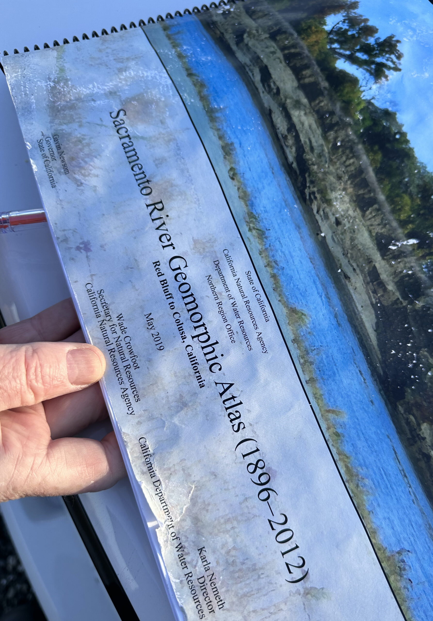
The atlas Henderson is thumbing through, the Sacramento River Geomorphic Atlas (1896-2012)—and occasionally referencing pages that show the spot we are standing on from different perspectives—tells the story of how the Sacramento River has changed over time. When left alone, that’s what rivers do. They braid and wind and move as they respond to everything from seasonal whims like water flows to more enduring traits, like the geology of the channel. One of the pages Henderson wants to show me is a view of all of the revetment in the area.
Revetment refers to rocks and rubble that are placed along the river’s banks to act as a kind of armor, with the aim of slowing erosion or keeping the river on a predictable path. The issue with this strategy is that if enough of a river is armored, then it stops being a river and starts to act more like a gigantic culvert: a ditch delivering water from one part of the state to the other. As Henderson describes it, “It disconnects a river from its floodplain.”
The other issue is that California’s topography and climate act in such a way that the river, and the native plants and animals that rely on it for feeding, forage, and shelter, are adapted to the Sacramento’s see-saw dynamics of seasonal high and low water. The historical and ecological variability of the river’s flows, fed by dozens of tributaries that run out to the San Francisco Estuary, has created cyclical opportunities for wildlife to grow and reproduce. Runs of spawning salmon are one example. And re-groomed river banks for swallows to burrow and build nests is another.
“The bank swallow serves as a keystone species,” says Ron Melcer, who studied the Sacramento River’s population as a PhD student at UC Davis and now oversees the California State Parks Wildlife Program. “There is no way to put a bird box up to protect this species. You need to provide its real natural habitat, which is actually a river interacting with the floodplain.”
Bank swallows are small brown songbirds with a double-chirp call that can sound almost mechanical, like when a wheel spins rhythmically but noisily on rusty bearings. They have a distinctive white, collar-like mark around their neck and live out in the open and along waterways, relying on eroding river and stream banks to create optimal conditions to dig deep tunnels (up to a foot-and-a-half in depth) that they excavate with their beak, feet, and wings. Males will dig the burrows in the early spring in hopes of attracting females. The colonies can number anywhere between 3 to 3,000 nearby burrows. They eat while flying—with busy, fluttering flight paths—often feeding on airborne insects.
Like their name implies, bank swallows build burrows in the sides of the Sacramento River’s sandy banks. Photo David Bogener
Bank swallows are found worldwide (in some places called sand martins) and recognized by conservation groups as a common species in sharp decline. In California, the state recognizes the bank swallow as a threatened species, but so far there are no federal protections for the birds. In the United States, the two big populations of bank swallows are in the Great Lakes region and along the Sacramento River.
One reason for the steep decline in their numbers is the steady loss of those eroding river and stream banks where they make nests and build colonies. When that habitat disappears, so do the bank swallows. According to some of Melcer’s research, the bank swallows also respond when their habitat improves, or when it’s restored. “Of the18 locations along the river where the rock was removed, either deliberately or because it was washed away, the swallows have come back in all but two,” Melcer says. “And they come back fast, like in one-in-a-half to two years.”
One site where Henderson points out the revetment on the atlas, and then walks me out to the river to see remnants of the rubble, is a place where a landowner dumped chunks of concrete along the bank years ago. Most of the debris was later removed, but a few pieces remain out in the river’s channel, acting like a reef. “There’s not a whole lot of new public rock going in these days,” Henderson says.
In decades past, armoring riverbanks with revetment used to be common practice—even among conservation groups thinking it would help with habitat protection. The Flood Control Act of 1960, for example, created the Sacramento River Bank Protection Project, which gave the U.S. Army Corps of Engineers, along with other agencies, the mandate to look for places to rock river banks as a means of flood protection.
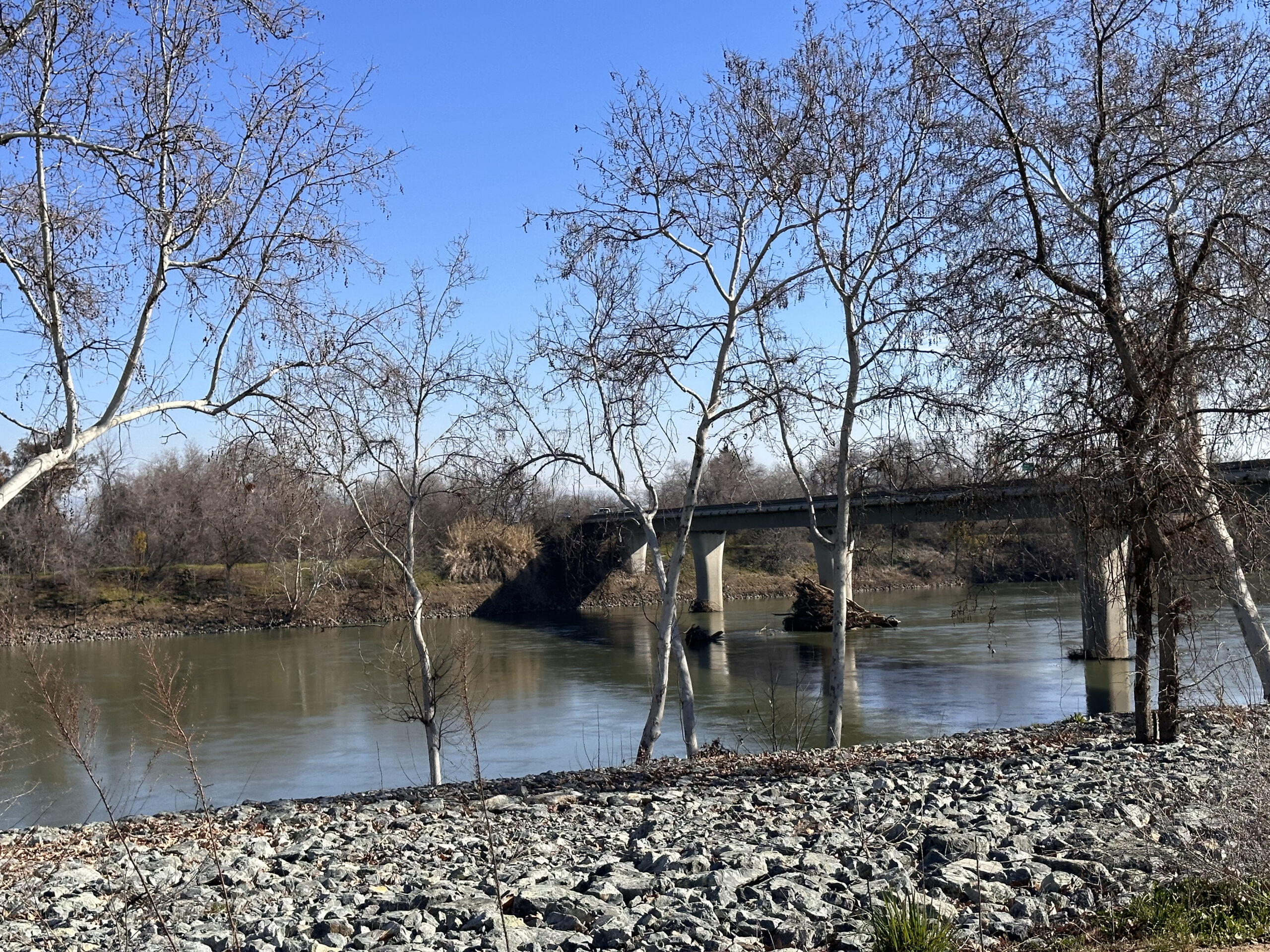
The bank near the footing of the Highway 32 bridge outside of Hamilton City is protected by rock. Photo Daniel McGlynn
But now, because of a better understanding of how the Sacramento River works as a system—and how constant erosion and deposition is an important ecological function providing specialized niches for local species—adding revetment to river banks is not as popular. Increasingly, any kind of new flood-protection measure is pushed farther back from where the river runs today, in hopes of allowing the dynamic processes created by the river to unfold. At least that’s the case on the Middle Sacramento, where there is room for things like setback flood protection. Downriver, because of increased population density, it’s a different story.
“Usually, we think of rivers getting wider as they move downstream, but the Sacramento River actually gets more constricted,” says Henderson. Creating space along the Sacramento River is a major theme of the Central Valley Flood Protection Board’s plan, which identifies flooding as one of the biggest public-safety issues facing residents of the Central Valley. Concerns about a future defined by unpredictable and heavy, wet storms increasing flood risk is a dominant theme throughout the plan, which was mandated by the 2008 Central Valley Flood Protection Act and just updated in December 2022.
“We will see things we have never seen before,” says Tim Ramirez, one of the flood board members. “It’s hard to move the [flood control] infrastructure, but in some cases we have room. Where we have room, the more infrastructure we can move back the better. More space will help us address uncertainty, because you can’t get space back.”
Making more space is a major theme that comes up along the Sacramento River’s 447-mile course. The river has been engineered and hardened to protect against flooding. But all of the tinkering on its banks have come at a cost to native species and the natural dynamics of the river. Until recently, it was hard to quantify those losses with respect to flood control. Or maybe put another way, it was really hard to pay for habitat restoration when there was so much flood control work to do. But now, in part because of some successful projects over the years on the Middle Sacramento, there is a model that shows how the return on investment of restoring river processes and their associated habitats while modernizing flood protection can address the dual threats of erratic river behavior and loss of native species across the region.
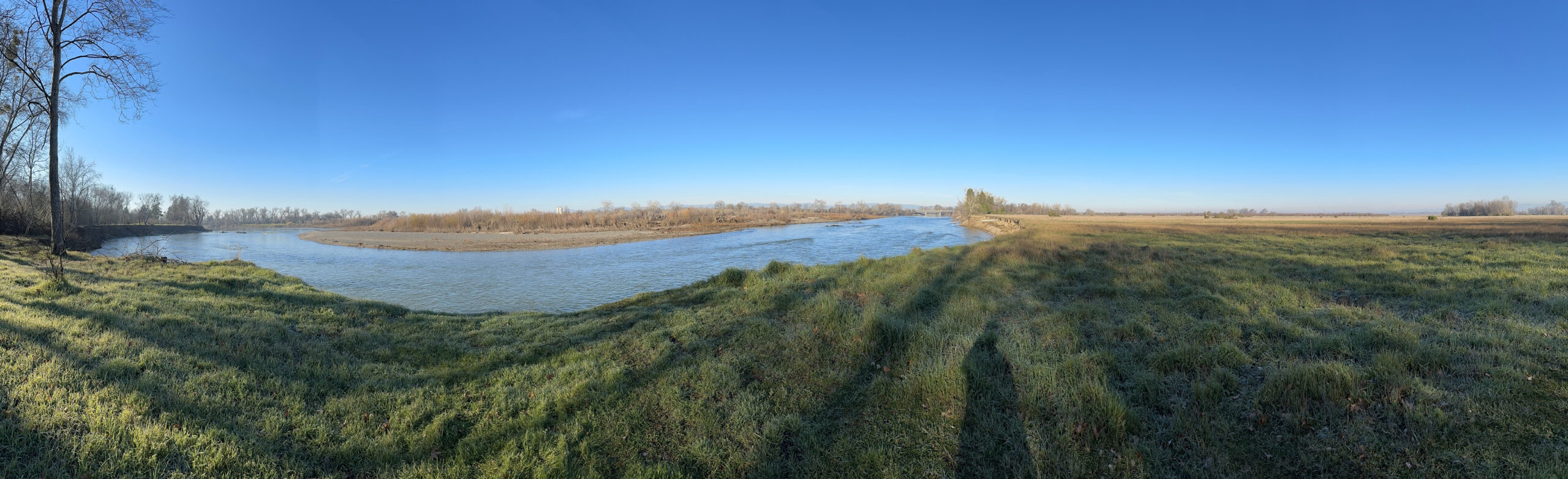
Overlooking the Sacramento River near the Pine Creek Unit parking lot. The Highway 32 bridge is visible. Photo: Daniel McGlynn
The Proving Ground
There’s a bridge just upriver of the bank swallow habitat I visited with Henderson that connects the small town of Hamilton City to nearby Chico via Highway 32. Immediately north of the bridge a cluster of newly placed big rocks protects its footing adjacent to a wide field covered in grass stubble. Rimming the field is a rise topped with a gravel road — a new levee pushed back from the river’s edge. Construction of the setback levee was completed in 2021, replacing an old levee that more closely hugged the bank of the river and creating 400 acres of new habitat now slated for restoration.
The newly created field and levee are components of the larger Hamilton City Flood Risk Reduction and Ecosystem Restoration Project. The community drove the project from the ground up, over 20 years, mainly because the city’s size and overall economics made a project of this scope easy to overlook. For years, residents’ pleas for more flood control went unanswered.
“Hamilton City is one of those places where it was difficult to use the traditional process to document who the beneficiaries were to be able to do the obvious things,” says Ramirez. That’s one of the reasons why the project is so unique and will result in 6.8 miles of new setback levee and 1,361 acres of restored riparian habitat area. Over the next year, this grass stubble field will be replanted with native riparian plants.
Orchards near the river. Photo: Daniel McGlynn
I met with Ryan Luster, senior project director for The Nature Conservancy, just downriver at the other end of the new levee. We are standing on the shoulder of Road 23, on top of the levee, right near another wildlife refuge parking lot. Looking north, the levee jaunts away from the river, which is just out of sight, behind clusters of trees. The east side of the levee, like most of the land nearby, is studded with the tidy rows of a working orchard—plum, walnut, and almonds are common crops around here. A pristine-looking gravel road tops the levee, which creates a pronounced ten-foot rise across otherwise flat fields. The levee here is lower than it is north of Hamilton City, where it has more of a job to do in terms of flood control. Here the “training levee,” as Luster calls it, protects agricultural land by slowing down high-water events.
To our west—the river side of the levee—there are two different parcels that are part of the restoration work happening in the former orchard land that lies between the river and the new setback levee. The parcels are transected by Road 23; one of them was planted in 2007 (before the new levee was built but with its future path in mind), and the other was planted in 2017.
Between the three restoration sites—the grass stubble by the bridge, the beginnings of a new riparian forest on property owned by a new local reclamation district on one side of the road, and then a more mature and well-established riparian forest restoration that is part of land managed as part of the wildlife refuge—a picture starts to emerge.
Ecological ROI
For years, Luster explains, The Nature Conservancy purchased land up and down the river and then restored it back to its riparian roots. But the Hamilton City project is different because of the scale of the project, both in terms of time and because of the amount of resources involved. Another thing that makes the project so different is how the community was able to pay for it all.
Hamilton City has a population of about 2,500 and sits at the intersections of Highway 32 and Highway 45, in Glenn County, which is also sparsely populated. The community, and the old levee that surrounded it, were first built in 1905 by James Hamilton, who had a sugar beet empire in the Central Valley. Vestiges of the sugar beet operation still exist, like a processing plant tower that serves as a benchmark in an otherwise tabletop landscape. After the sugar beet bust, the dominant economy became orchard crops. Hamilton City never grew much beyond several square blocks established during its company town days.
Public access site to Sacramento River. Photo: Daniel McGlynn
The threat of flood is persistent in Hamilton City. Residents evacuated six times in the last 30 years due to high-water threats, and instances of flood fighting are fairly routine. The town’s levee system, named on historic maps as “J Levee,” was privately owned. Maintaining it was never officially the responsibility of any local, state, or federal government. For years, the community asked for better flood protection. And for years, a new flood-control infrastructure project built by the U.S. Army Corps of Engineers (they are the chief levee builder along the Sacramento River and elsewhere) wouldn’t pencil out.
To put it simply, protecting the town’s value (in terms of property) didn’t justify the expense of building a new levee. It was more cost-effective to just fight floods when needed. In 2000, the return-on-investment calculation changed, however, when Congress acknowledged that the economic benefits of ecological restoration could factor into new flood-control projects built by the Corps of Engineers.
The Hamilton City Flood Risk Reduction and Ecosystem Restoration Project is a perfect example (and the first in the nation) of how viewing flood control more holistically can have multiple benefits. “The key to this whole project was the cost-benefit ratio,” says Luster. “For years and years, just building a new levee wasn’t economically justified, but then once we could add in the habitat benefits, it worked. Basically, 90% of the project benefits are ecosystem benefits, and those ecosystem benefits are what pay for the new setback levee.”
On paper, project planners could show that a new levee setback from the river channel—leaving wide swaths for habitat restoration—could create more space for the Sacramento River to meander, reduce flood risk to Hamilton City, and allow more room for the region’s native plant and animal species to recover from decades of habitat loss. “The Army Corps of Engineers brought in the U.S. Fish and Wildlife Service to put a dollar amount on the 1,400 acres of the restored habitat,” Luster explains.
One of the biggest issues facing the project was that there wasn’t an official “non-federal partner.” Levees, flood protection, and habitat restoration all take money to maintain and function properly, so the big question for the residents of Hamilton City was who would take care of a big new project once built? The state and the county (typical candidates for non-federal partners) were reluctant to take on more flood-related liability. So the project proponents involved in the early days of the process started consulting with lawyers and figured out that under state law, the community could create a new kind of local-government entity called a reclamation district. Voters approved Reclamation District 2140 in 2005 to start working on flood-control issues around Hamilton City, with the sole purpose of becoming the non-federal sponsor for the project.
J-levee map. Courtesy Reclamation District 2140.
Better flood control was so important to Hamilton City’s residents that even before Congress approved the project, the new reclamation district, again with voter approval, started taxing residents and businesses. The tax, which now helps pay for levee maintenance is proportional to flood-control benefits received by each taxpayer (big landowners pay more than someone who owns a house in town).
Meanwhile, The Nature Conservancy worked with the community and local landowners to buy property where the future Hamilton City project would be situated. Eventually, the nonprofit turned the land over to the newly formed reclamation district, which was able to use the value of the land as Hamilton City’s monetary contribution to the project as the non-federal sponsor.
After delays because of national politics, the economic crisis of 2008, and other setbacks, construction of the Hamilton City project finally got underway in 2016. The first fully restored spot is where I stood with Luster next to Road 23. “The way we describe the project, it’s the first multi-benefit project designed by the Army Corps in the United States. From the very beginning, this was a habitat-restoration and a flood-risk-reduction project,” Luster says. “We wanted this to be a model for the Army Corps nationally, and in California, particularly in the Central Valley, where everyone realizes that we needed a different approach to flood-risk reduction and habitat restoration.”
A view of the new setback levee from Road 23. Photo by Daniel McGlynn
Around the Bend
Back when I stood on the big bank overlooking the river with Henderson, he explained what things look like during times of drought and during peak water events. And he described the scene when the bank swallows return in full burrow-building mode. There could be hundreds of birds swooping and swinging right along the river where we stood.
But despite all the evidence, and despite his help, I still couldn’t visualize it. As I read the descriptions and forecasts in the latest update of the Central Valley Flood Protection Plan, I had a similar problem. Models depicting greater warm-weather storms, more flooding, and more intense and prolonged strings of drought seem almost incomprehensible. All of the outcomes feel fuzzy despite the stories of the historic record and the scientific evidence showing that the region’s weather will only become more erratic.
And maybe that’s the biggest lesson learned from the Middle Sacramento River. Preparing for the future is not only about restoring the natural processes and creating habitat for a threatened species, or re-situating levees and rethinking armored banks. It’s also about getting ready for a future we can’t quite comprehend yet. That might be the biggest challenge—but it also provides the greatest opportunities for imagining large-scale, ecologically-based infrastructure.
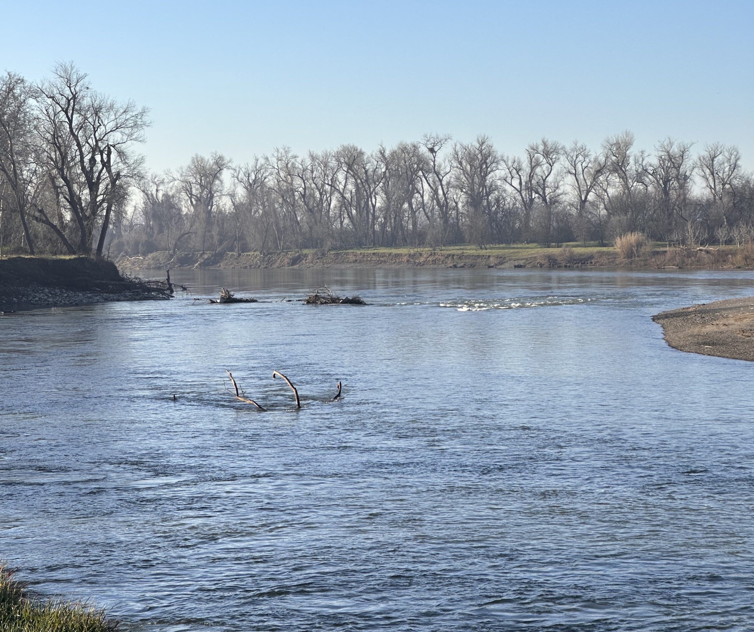
Top Photo: A freshly groomed bank far left. Some of the old revetment now forms riffles mid-river. Photo: Daniel McGlynn
Daniel McGlynn worked as an itinerant naturalist, trip leader, and wilderness guide before serving as an environmental educator with the Peace Corps in rural Nicaragua. Realizing that storytelling is a great educational tool, and productive way to inspire understanding and change, he then turned his attention to science and environmental writing. He is an alum of UC Berkeley’s Graduate School of Journalism and his work has appeared in a handful of national publications. He frequently writes about infrastructure projects and restoration work for Estuary News. Connect with him at danielmcglynn.com.
Our magazine’s media motto for many years has been “Where there’s an estuary, there’s a crowd.” The San Francisco Estuary is a place where people, wildlife, and commerce congregate, and where watersheds, rivers and the ocean meet and mix, creating a place of unusual diversity. In choosing to tell the...
Ever since the state and federal water projects were built in the 1930s and 1940s, California has captured snowmelt in foothill reservoirs, and moved the fresh water from dam releases and river outflows to parched parts of the state via aqueducts hundreds of miles long. A convoluted system of ancient...
Though the Clean Water Act did an amazing job of reducing wastewater and stormwater pollution of the San Francisco Estuary, some contaminants remain thorny problems. Legacy pollutants like mercury washed into the watershed from upstream gold mining, PCBs from old industrial sites, and selenium from agricultural drainage in the San...
Hothouse Earth
By Ariel Rubissow Okamoto
Photo by Megan Nguyen
Nothing could be stranger than sitting in the dark with thousands of suits and heels, watching a parade of promises to decarbonize from companies and countries large and small, reeling from the beauties of big screen rainforests and indigenous necklaces, and getting all choked up.
It was day two of the September 2018 Global Climate Action Summit in San Francisco when I felt it.
At first I wondered if I was simply starstruck. Most of us labor away trying to fix one small corner of the planet or another without seeing the likes of Harrison Ford, Al Gore, Michael Bloomberg, Van Jones, Jerry Brown – or the ministers or mayors of dozens of cities and countries – in person, on stage and at times angry enough to spit. And between these luminaries a steady stream of CEOs, corporate sustainability officers, and pension fund managers promising percentages of renewables and profits in their portfolios dedicated to the climate cause by 2020-2050.
I tried to give every speaker my full attention: the young man of Vuntut Gwichin heritage from the edge of the Yukon’s Arctic National Wildlife Refuge who pleaded with us not to enter his sacred lands with our drills and dependencies; all the women – swathed in bright patterns and head-scarfs – who kept punching their hearts. “My uncle in Uganda would take 129 years to emit the same amount of carbon as an American would in one year,” said Oxfam’s Winnie Byanyima.
“Our janitors are shutting off the lights you leave on,” said Aida Cardenas, speaking about the frontline workers she trains, mostly immigrants, who are excited to be part of climate change solutions in their new country.
The men on the stage, strutting about in feathers and pinstripes, spoke of hopes and dreams, money and power. “The notion that you can either do good or do well is a myth we have to collectively bust,” said New Jersey Governor Phil Murphy whose state is investing heavily in offshore wind farms.
“Climate change isn’t just about risks, it’s about opportunities,” said Blackrock sustainable investment manager Brian Deese.
But it wasn’t all these fine speeches that started the butterflies. Halfway through the second day of testimonials, it was a slight white-haired woman wrapped in an azure pashmina that pricked my tears. One minute she was on the silver screen with Alec Baldwin and the next she taking a seat on stage. She talked about trees. How trees can solve 30% of our carbon reduction problem. How we have to stop whacking them back in the Amazon and start planting them everywhere else. I couldn’t help thinking of Dr. Seuss and his truffala trees. Jane Goodall, over 80, is as fierce as my Lorax. Or my daughter’s Avatar.
Analyzing my take home feeling from the event I realized it wasn’t the usual fear – killer storms, tidal waves, no food for my kids to eat on a half-baked planet – nor a newfound sense of hope – I’ve always thought nature will get along just fine without us. What I felt was relief. People were actually doing something. Doing a lot. And there was so much more we could do.
As we all pumped fists in the dark, as the presentations went on and on and on because so many people and businesses and countries wanted to STEP UP, I realized how swayed I had let myself be by the doomsday news mill.
“We must be like the river, “ said a boy from Bangladesh named Risalat Khan, who had noticed our Sierra watersheds from the plane. “We must cut through the mountain of obstacles. Let’s be the river!”
Or as Harrison Ford less poetically put it: “Let’s turn off our phones and roll up our sleeves and kick this monster’s ass.”
4th California Climate Change Assessment Blues
by Isaac Pearlman
Since California’s last state-led climate change assessment in 2012, the Golden State has experienced a litany of natural disasters. This includes four years of severe drought from 2012 to 2016, an almost non-existent Sierra Nevada snowpack in 2014-2015 costing $2.1 billion in economic losses, widespread Bay Area flooding from winter 2017 storms, and extremely large and damaging wildfires culminating with this year’s Mendocino Complex fire achieving the dubious distinction of the largest in state history. California’s most recent climate assessment, released August 27th, predicts that for the state and the Bay Area, we can expect even more in the future.
The California state government first began assessing climate impacts formally in 2006, due to an executive order by Governor Schwarzenegger. California’s latest iteration and its fourth overall, includes a dizzying array of 44 technical reports; three topical studies on climate justice, tribal and indigenous communities, and the coast and ocean; as well as nine region-specific analyses.
The results are alarming for our state’s future: an estimated four to five feet of sea level rise and loss of one to two-thirds of Southern California beaches by 2100, a 50 percent increase in wildfires over 25,000 acres, stronger and longer heat waves, and infrastructure like airports, wastewater treatment plants, rail and roadways increasingly likely to suffer flooding.
For the first time, California’s latest assessment dives into climate consequences on a regional level. Academics representing nine California regions spearheaded research and summarized the best available science on the variable heat, rain, flooding and extreme event consequences for their areas. For example, the highest local rate of sea level rise in the state is at the rapidly subsiding Humboldt Bay. In San Diego county, the most biodiverse in all of California, preserving its many fragile and endangered species is an urgent priority. Francesca Hopkins from UC Riverside found that the highest rate of childhood asthma in the state isn’t an urban smog-filled city but in the Imperial Valley, where toxic dust from Salton Sea disaster chokes communities – and will only become worse as higher temperatures and less water due to climate change dry and brittle the area.
According to the Bay Area Regional Report, since 1950 the Bay Area has already increased in temperature by 1.7 degrees Fahrenheit and local sea level is eight inches higher than it was one hundred years ago. Future climate will render the Bay Area less suitable for our evergreen redwood and fir forests, and more favorable for tolerant chaparral shrub land. The region’s seven million people and $750 billion economy (almost one-third of California’s total) is predicted to be increasingly beset by more “boom and bust” irregular wet and very dry years, punctuated by increasingly intense and damaging storms.
Unsurprisingly, according to the report the Bay Area’s intensifying housing and equity problems have a multiplier affect with climate change. As Bay Area housing spreads further north, south, and inland the result is higher transportation and energy needs for those with the fewest resources available to afford them; and acute disparity in climate vulnerability across Bay Area communities and populations.
“All Californians will likely endure more illness and be at greater risk of early death because of climate change,” bluntly states the statewide summary brochure for California’s climate assessment. “[However] vulnerable populations that already experience the greatest adverse health impacts will be disproportionately affected.”
“We’re much better at being reactive to a disaster than planning ahead,” said UC Berkeley professor and contributing author David Ackerly at a California Adaptation Forum panel in Sacramento on August 27th. “And it is vulnerable communities that suffer from those disasters. How much human suffering has to happen before it triggers the next round of activity?”
The assessment’s data is publicly available online at “Cal-adapt,” where Californians can explore projected impacts for their neighborhoods, towns, and regions.


 The results are alarming for our state’s future: an estimated four to five feet of sea level rise and loss of one to two-thirds of Southern California beaches by 2100, a 50 percent increase in wildfires over 25,000 acres, stronger and longer heat waves, and infrastructure like airports, wastewater treatment plants, rail and roadways increasingly likely to suffer flooding.