It’s largely taken for granted within the San Francisco Bay environmental community today that public trails through parks and preserves are both right and good: right, in the sense that they can offer equitable access to our region’s most treasured natural assets; and good, because they engender support for protection and restoration. But along the waterfront, trails weren’t always so welcome.
“The local chapters of the Audubon Society and the Sierra Club were adamantly opposed,” recalls Tom Mikkelsen, who led implementation of the Bay Trail, an ambitious multi-use trail ringing the Bay, from its inception in 1988 until 2001. “Every time we came up with a project that was close to the edge of the Bay, they opposed it. And the issue was that ‘it had to be preserved, and preservation was the first order of business.’”
Their concern that more access to the shoreline would imperil its remaining habitat was not entirely unfounded. It likely came as an over-correction for abuses the Bay had suffered in previous years through dumping and infill, damages that gave rise to the Bay Area environmental movement in the first place. Yet slowly, over the course of decades, the once-paradoxical concept that access might translate to protection became common sense within the restoration community. “They eventually saw these things as mutually supporting,” Mikkelsen says.
During his 13-year tenure, the San Francisco Bay Trail grew by almost 100 miles. The system’s total mileage today is just north of 350, with 150 more needed to complete the trail. But the annual growth rate has slowed to a crawl as only the most difficult segments remain.
One recent addition exemplifies how current roadblocks to Bay Trail expansion aren’t political in nature, but logistical. More importantly, it illustrates the progression of public-access goals since the late 1980s, from simply building trails to prioritizing equity and community engagement.
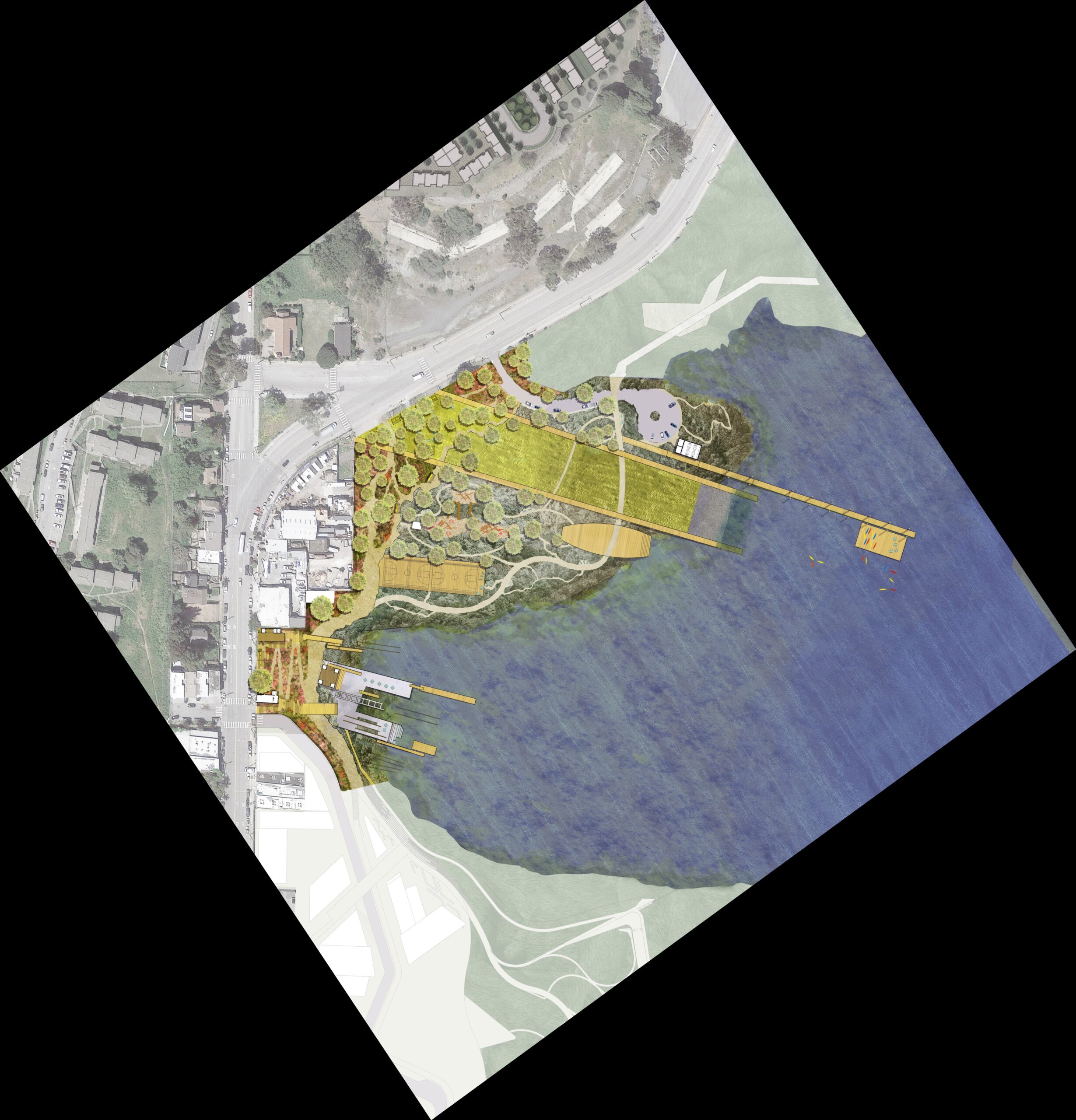
When complete in the summer of 2026, the India Basin Waterfront Park Project will transform a section of San Francisco’s shoreline in the Bayview-Hunters Point neighborhood from a polluted former industrial site to a thriving natural area and gathering spot with a restored shoreline. It will also close a small yet critical gap in the San Francisco Bay Trail and serve as the midpoint of the 1.5-mile India Basin shoreline trail, which spans a total of seven properties including restored Heron’s Head Park to the north.
India Basin site plan. Map: SFRP
Part of the project area was so degraded by previous uses (with no existing marsh to preserve) that multiple trails, docks, buildings, and recreational facilities could be considered from the start—with community input—right alongside plans for upland plantings and new shoreline and wetland habitat. Public access and environmental restoration goals were considered together throughout the design and permitting process, says San Francisco Recreation and Parks Department project manager David Froehlich. SF Rec and Parks, which owns the land, collaborated particularly closely with the Bay Conservation and Development Commission (BCDC), Froehlich notes—an organization whose mission, alongside protecting and enhancing the Bay, involves providing public access.
Similarly, the voter-approved San Francisco Bay Restoration Authority, which contributed nearly $5 million to the project’s $200 million budget, considers public access an essential element of its mandate. So does the State Coastal Conservancy, which helps run the Restoration Authority; in recent years, its concept of access has broadened well beyond the Bay Trail itself to include other design elements that are responsive to community needs, as well as transportation to and from shoreline parks and trailheads.
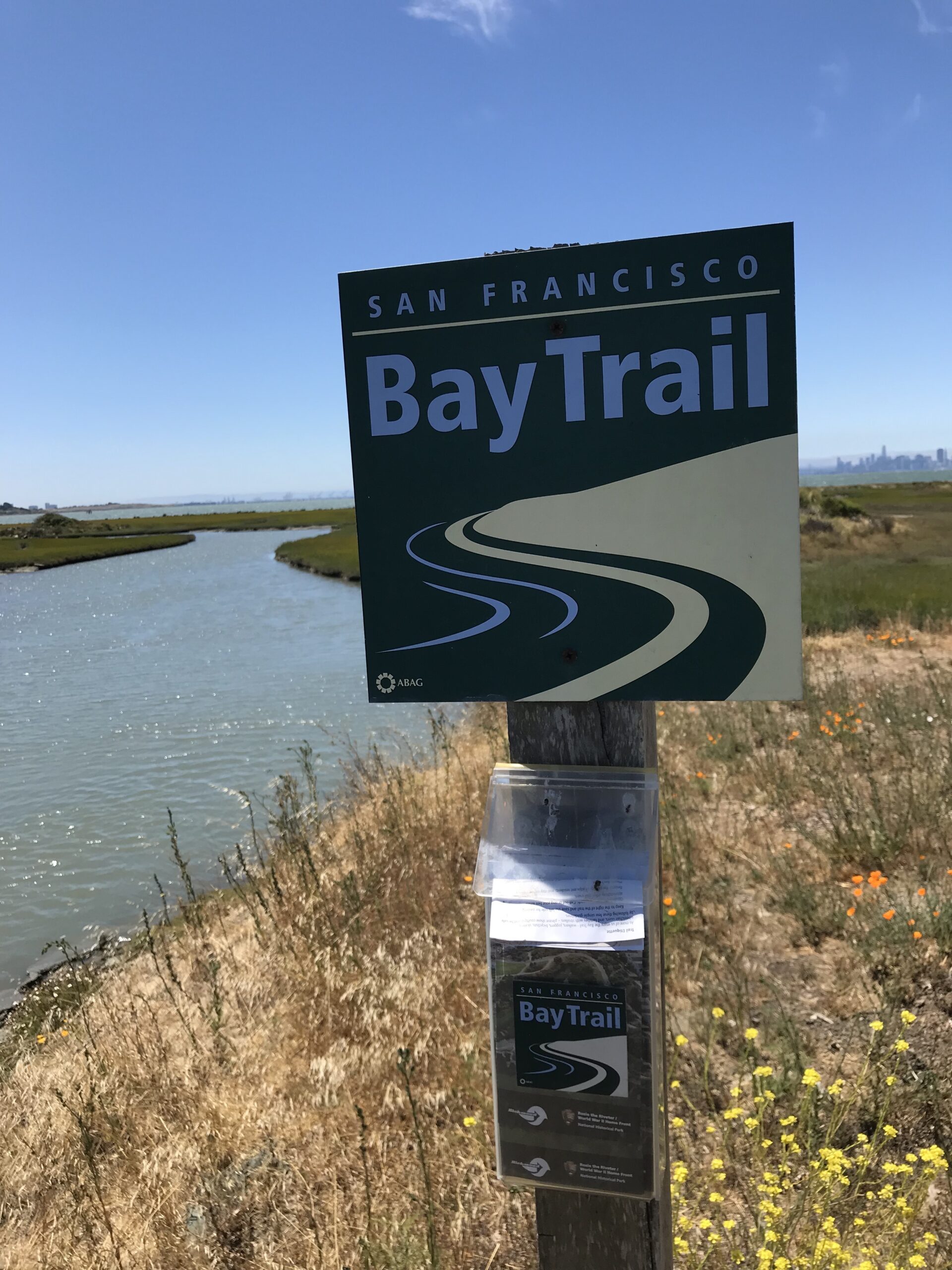
Bay Trail at Fagan Marsh State Marine Park, Napa County. Photo: Karl Nielsen
The pandemic has accelerated this ongoing evolution in thinking at agencies around the Bay, says San Francisco Estuary Partnership director Caitlin Sweeney. “It really drove home the point that access to open space is so critical for our health and well- being, but is not provided equitably throughout our region,” she says. “I think that’s where we’re gonna see the push. We’re also going to see an acknowledging of the different ways we use open space.”
Still, public access must remain compatible with other goals. Different agencies with which the Coastal Conservancy partners manage different properties for different purposes, says deputy program manager Jessica Davenport. For example, “there are California State Parks that are more oriented toward public access and recreation. But California Wildlife Areas are primarily for wildlife.” There, public access is, by law, “focused on wildlife-oriented recreation, like fishing, hunting, bird watching,, and nature study, [and] they have a very limited budget to maintain public facilities,” Davenport says.
Bay Trail map. Map: ABAG
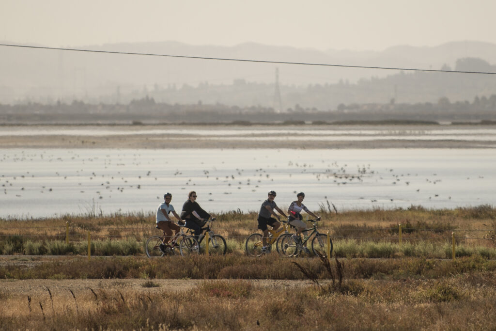
Case in point: the California Department of Fish and Game’s Napa-Sonoma Marshes Wildlife Area. If India Basin is on one end of the public-access spectrum among San Francisco Bay wetlands, this vast tidal complex surrounding Highway 37 is on the other: difficult to access (mostly by boat) and ultimately managed for wildlife.
The area also includes the largest remaining contiguous gap in the San Francisco Bay Trail, planned to one day follow the highway’s path across the marsh. Mikkelsen says he remains optimistic, just as he was in the late 1980s, that the trail will eventually be completed. “I’d hoped to see this thing done by the time I retired,” he says. “That didn’t happen. So now I’m hoping that I’ll see it by the time I kick the bucket. And that may may not happen. But maybe my kids or their children will be able to [see] it, and I think that’s terrific.”
After all, few experiences are more inspirational, and more motivating to continue to protect this regional centerpiece, than reaching the Bay’s edge, peering over sinewy channels of healthy tidal marsh toward miles of open water, and contemplating how far we’ve come.
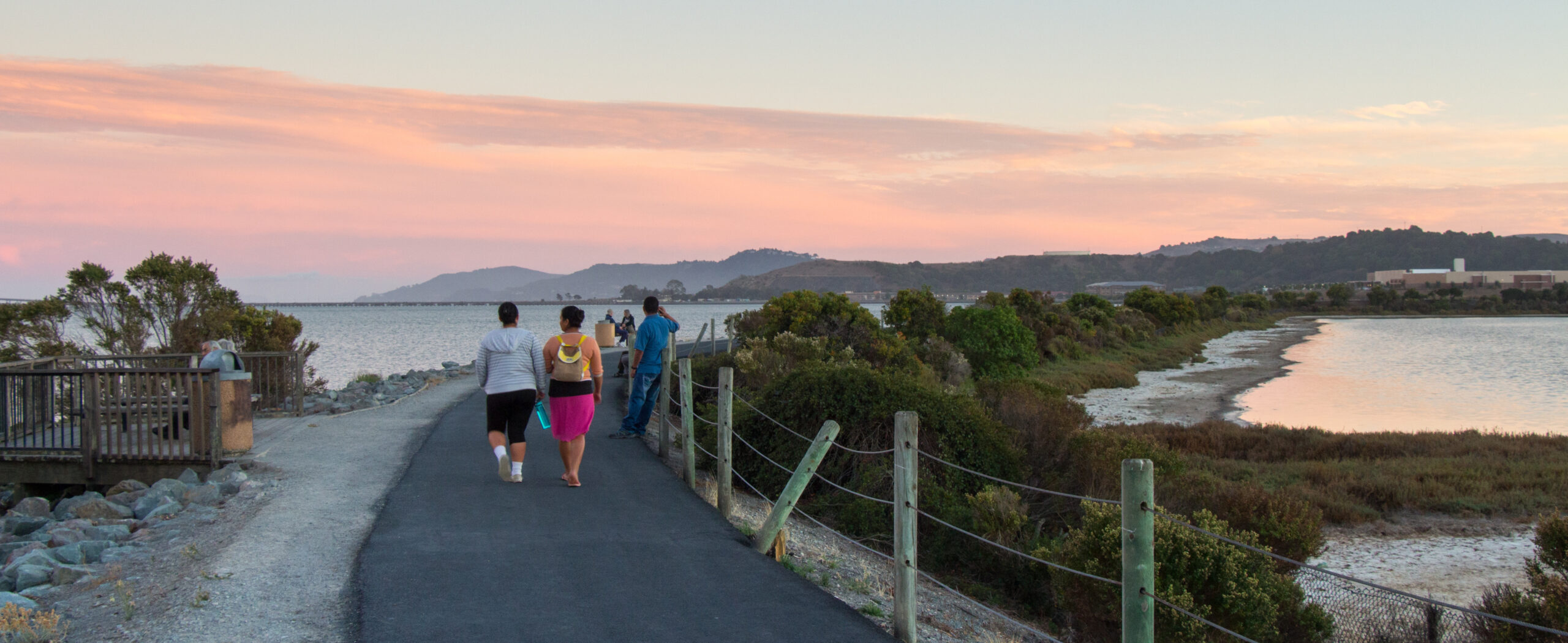
Top Photo: Bay Trail in Richmond. Photo: Ben Botkin
Nate Seltenrich is a freelance science and environmental journalist who covers infrastructure, restoration, and related topics for Estuary. He also contributes to the San Francisco Chronicle, Sonoma and Marin magazines, the journal Environmental Health Perspectives, and other local and national publications, on subjects ranging from public lands and renewable energy to the human health impacts of climate change. He lives in Petaluma with his wife, two boys, and four ducks. www.nate-reports.com
Our magazine’s media motto for many years has been “Where there’s an estuary, there’s a crowd.” The San Francisco Estuary is a place where people, wildlife, and commerce congregate, and where watersheds, rivers and the ocean meet and mix, creating a place of unusual diversity. In choosing to tell the...
Ever since the state and federal water projects were built in the 1930s and 1940s, California has captured snowmelt in foothill reservoirs, and moved the fresh water from dam releases and river outflows to parched parts of the state via aqueducts hundreds of miles long. A convoluted system of ancient...
Though the Clean Water Act did an amazing job of reducing wastewater and stormwater pollution of the San Francisco Estuary, some contaminants remain thorny problems. Legacy pollutants like mercury washed into the watershed from upstream gold mining, PCBs from old industrial sites, and selenium from agricultural drainage in the San...
Hothouse Earth
By Ariel Rubissow Okamoto
Photo by Megan Nguyen
Nothing could be stranger than sitting in the dark with thousands of suits and heels, watching a parade of promises to decarbonize from companies and countries large and small, reeling from the beauties of big screen rainforests and indigenous necklaces, and getting all choked up.
It was day two of the September 2018 Global Climate Action Summit in San Francisco when I felt it.
At first I wondered if I was simply starstruck. Most of us labor away trying to fix one small corner of the planet or another without seeing the likes of Harrison Ford, Al Gore, Michael Bloomberg, Van Jones, Jerry Brown – or the ministers or mayors of dozens of cities and countries – in person, on stage and at times angry enough to spit. And between these luminaries a steady stream of CEOs, corporate sustainability officers, and pension fund managers promising percentages of renewables and profits in their portfolios dedicated to the climate cause by 2020-2050.
I tried to give every speaker my full attention: the young man of Vuntut Gwichin heritage from the edge of the Yukon’s Arctic National Wildlife Refuge who pleaded with us not to enter his sacred lands with our drills and dependencies; all the women – swathed in bright patterns and head-scarfs – who kept punching their hearts. “My uncle in Uganda would take 129 years to emit the same amount of carbon as an American would in one year,” said Oxfam’s Winnie Byanyima.
“Our janitors are shutting off the lights you leave on,” said Aida Cardenas, speaking about the frontline workers she trains, mostly immigrants, who are excited to be part of climate change solutions in their new country.
The men on the stage, strutting about in feathers and pinstripes, spoke of hopes and dreams, money and power. “The notion that you can either do good or do well is a myth we have to collectively bust,” said New Jersey Governor Phil Murphy whose state is investing heavily in offshore wind farms.
“Climate change isn’t just about risks, it’s about opportunities,” said Blackrock sustainable investment manager Brian Deese.
But it wasn’t all these fine speeches that started the butterflies. Halfway through the second day of testimonials, it was a slight white-haired woman wrapped in an azure pashmina that pricked my tears. One minute she was on the silver screen with Alec Baldwin and the next she taking a seat on stage. She talked about trees. How trees can solve 30% of our carbon reduction problem. How we have to stop whacking them back in the Amazon and start planting them everywhere else. I couldn’t help thinking of Dr. Seuss and his truffala trees. Jane Goodall, over 80, is as fierce as my Lorax. Or my daughter’s Avatar.
Analyzing my take home feeling from the event I realized it wasn’t the usual fear – killer storms, tidal waves, no food for my kids to eat on a half-baked planet – nor a newfound sense of hope – I’ve always thought nature will get along just fine without us. What I felt was relief. People were actually doing something. Doing a lot. And there was so much more we could do.
As we all pumped fists in the dark, as the presentations went on and on and on because so many people and businesses and countries wanted to STEP UP, I realized how swayed I had let myself be by the doomsday news mill.
“We must be like the river, “ said a boy from Bangladesh named Risalat Khan, who had noticed our Sierra watersheds from the plane. “We must cut through the mountain of obstacles. Let’s be the river!”
Or as Harrison Ford less poetically put it: “Let’s turn off our phones and roll up our sleeves and kick this monster’s ass.”
4th California Climate Change Assessment Blues
by Isaac Pearlman
Since California’s last state-led climate change assessment in 2012, the Golden State has experienced a litany of natural disasters. This includes four years of severe drought from 2012 to 2016, an almost non-existent Sierra Nevada snowpack in 2014-2015 costing $2.1 billion in economic losses, widespread Bay Area flooding from winter 2017 storms, and extremely large and damaging wildfires culminating with this year’s Mendocino Complex fire achieving the dubious distinction of the largest in state history. California’s most recent climate assessment, released August 27th, predicts that for the state and the Bay Area, we can expect even more in the future.
The California state government first began assessing climate impacts formally in 2006, due to an executive order by Governor Schwarzenegger. California’s latest iteration and its fourth overall, includes a dizzying array of 44 technical reports; three topical studies on climate justice, tribal and indigenous communities, and the coast and ocean; as well as nine region-specific analyses.
The results are alarming for our state’s future: an estimated four to five feet of sea level rise and loss of one to two-thirds of Southern California beaches by 2100, a 50 percent increase in wildfires over 25,000 acres, stronger and longer heat waves, and infrastructure like airports, wastewater treatment plants, rail and roadways increasingly likely to suffer flooding.
For the first time, California’s latest assessment dives into climate consequences on a regional level. Academics representing nine California regions spearheaded research and summarized the best available science on the variable heat, rain, flooding and extreme event consequences for their areas. For example, the highest local rate of sea level rise in the state is at the rapidly subsiding Humboldt Bay. In San Diego county, the most biodiverse in all of California, preserving its many fragile and endangered species is an urgent priority. Francesca Hopkins from UC Riverside found that the highest rate of childhood asthma in the state isn’t an urban smog-filled city but in the Imperial Valley, where toxic dust from Salton Sea disaster chokes communities – and will only become worse as higher temperatures and less water due to climate change dry and brittle the area.
According to the Bay Area Regional Report, since 1950 the Bay Area has already increased in temperature by 1.7 degrees Fahrenheit and local sea level is eight inches higher than it was one hundred years ago. Future climate will render the Bay Area less suitable for our evergreen redwood and fir forests, and more favorable for tolerant chaparral shrub land. The region’s seven million people and $750 billion economy (almost one-third of California’s total) is predicted to be increasingly beset by more “boom and bust” irregular wet and very dry years, punctuated by increasingly intense and damaging storms.
Unsurprisingly, according to the report the Bay Area’s intensifying housing and equity problems have a multiplier affect with climate change. As Bay Area housing spreads further north, south, and inland the result is higher transportation and energy needs for those with the fewest resources available to afford them; and acute disparity in climate vulnerability across Bay Area communities and populations.
“All Californians will likely endure more illness and be at greater risk of early death because of climate change,” bluntly states the statewide summary brochure for California’s climate assessment. “[However] vulnerable populations that already experience the greatest adverse health impacts will be disproportionately affected.”
“We’re much better at being reactive to a disaster than planning ahead,” said UC Berkeley professor and contributing author David Ackerly at a California Adaptation Forum panel in Sacramento on August 27th. “And it is vulnerable communities that suffer from those disasters. How much human suffering has to happen before it triggers the next round of activity?”
The assessment’s data is publicly available online at “Cal-adapt,” where Californians can explore projected impacts for their neighborhoods, towns, and regions.


 The results are alarming for our state’s future: an estimated four to five feet of sea level rise and loss of one to two-thirds of Southern California beaches by 2100, a 50 percent increase in wildfires over 25,000 acres, stronger and longer heat waves, and infrastructure like airports, wastewater treatment plants, rail and roadways increasingly likely to suffer flooding.