In 2012 a team of salmon researchers tried a wild idea: putting pinky-sized Chinook on a rice field in the Yolo Bypass, a vast engineered floodplain designed to protect the city of Sacramento from inundation. The team found that rearing fish on farms works better than they had ever dreamed. Salmon in this managed floodplain grew so fast — averaging more than one millimeter per day — that they outpaced young Chinook elsewhere in the region. Now, after nearly a decade of testing fish in fields, a new paper in San Francisco Estuary and Watershed Science outlines lessons learned as well as next steps in managing floodplains for salmon.
“There’s some urgency,” says lead author Ted Sommer, a native fish expert at the state Department of Water Resources, which manages the Yolo Bypass as a floodway. “There’s been a long-term decline in Chinook salmon.”
Floodplains once served as nurseries for young salmon migrating from mountain streams to the ocean. Today, however, most of the low-lying land along California rivers is leveed and farmed. “They’re one of the more important areas we could improve,” Sommer says. “We’re looking for creative solutions — can we make farming more fish friendly?” The big question is whether fields that produce rice can also be managed as floodplains.
Yolo Bypass. Video: Jak Wonderly
Basin to bypass
The Yolo Basin was once an enormous wetland along the Sacramento River, covering an area about 40 miles long and up to seven miles wide from what is now Knights Landing to the Sacramento-San Joaquin Delta. Early accounts described the basin as an immense sea during severe winters. As rainstorms swelled the river and local streams, floodwaters overtopped their banks and spread over the basin at depths ranging from as much as 20 feet by the riverbanks to just a few inches farther out. These floodwaters moved slowly in a broad sheet through the wetlands to the Delta, taking so long to drain that the basin was impassable half the year.
Riparian forests thick with cottonwoods, sycamores, and oaks grew on natural streamside berms. The rest of the Yolo Basin was dominated by freshwater marsh filled with dense stands of tule more than 10 feet high. In an 1870 volume called The Western Shore Gazetteer, Yolo County, C.P. Sprague and H.W. Atwell told of “simply immense rushes, which cover the ground with an almost impenetrable thicket.”
Herds of tule elk wandered the basin’s marshes and grizzly bears abounded. Astonishing numbers of geese and ducks thronged to the basin to feed and rest during their winter migrations along the Pacific Flyway. Lansford W. Hastings recounted the spectacle in his 1945 book The Emigrants’ Guide to Oregon and California, describing the innumerable flocks as “at times blackening the very heavens,” and their “tumultuous croaking and vehement [squawking]” as almost deafening.
The Yolo Basin was also a paradise for salmon and other fish. Young salmon grew big and fat in the basin’s floodplain nurseries on their way down to the ocean, and returning adults swam back up the basin toward their natal spawning grounds. Salmon were so plentiful that people with handheld nets hauled in tremendous catches from the banks of the Tule Canal, an early effort to drain the basin that was built in 1864.
Today much of this historical floodplain is occupied by the 59,000-acre Yolo Bypass. Built about 100 years ago, the bypass is an imposing structure: 40 miles long, two to three miles wide, and bounded by 20-foot earthen levees. Sacramento River floodwaters pour into the bypass at the top and flow out to the Delta at the bottom. The land in the bypass is a mix of private farms and duck clubs and public wildlife areas.
Birds enjoy the food-rich shallows of Delta floodplains and rice fields as much as fish. Video: Jak Wonderly
Managed floodplains
Given these extensive alterations, it’s no surprise that biologists assumed the Yolo Bypass was no longer a good place for fish. That perception began to turn around in the late 1990s, when Sommer went into the bypass and saw that many fish species thrive there in wetter winters. “We found that it was a major fish nursery,” he recalls. In hindsight, it makes perfect sense because even now the bypass is an expanse of inland sea after heavy rains. That said, it was still a big leap to put young salmon on rice fields. Even Sommer had doubts.
He knew pesticides wouldn’t be a problem in winter-flooded rice fields. These agricultural chemicals are applied in the spring and break down fast in the environment. But he did worry that decomposing rice stubble, which is left on the fields after the fall harvest, would use up oxygen in the water and suffocate the fish. “I was nervous initially — but despite the fact that we’re taking about agricultural fields, it’s pretty good fish habitat.”
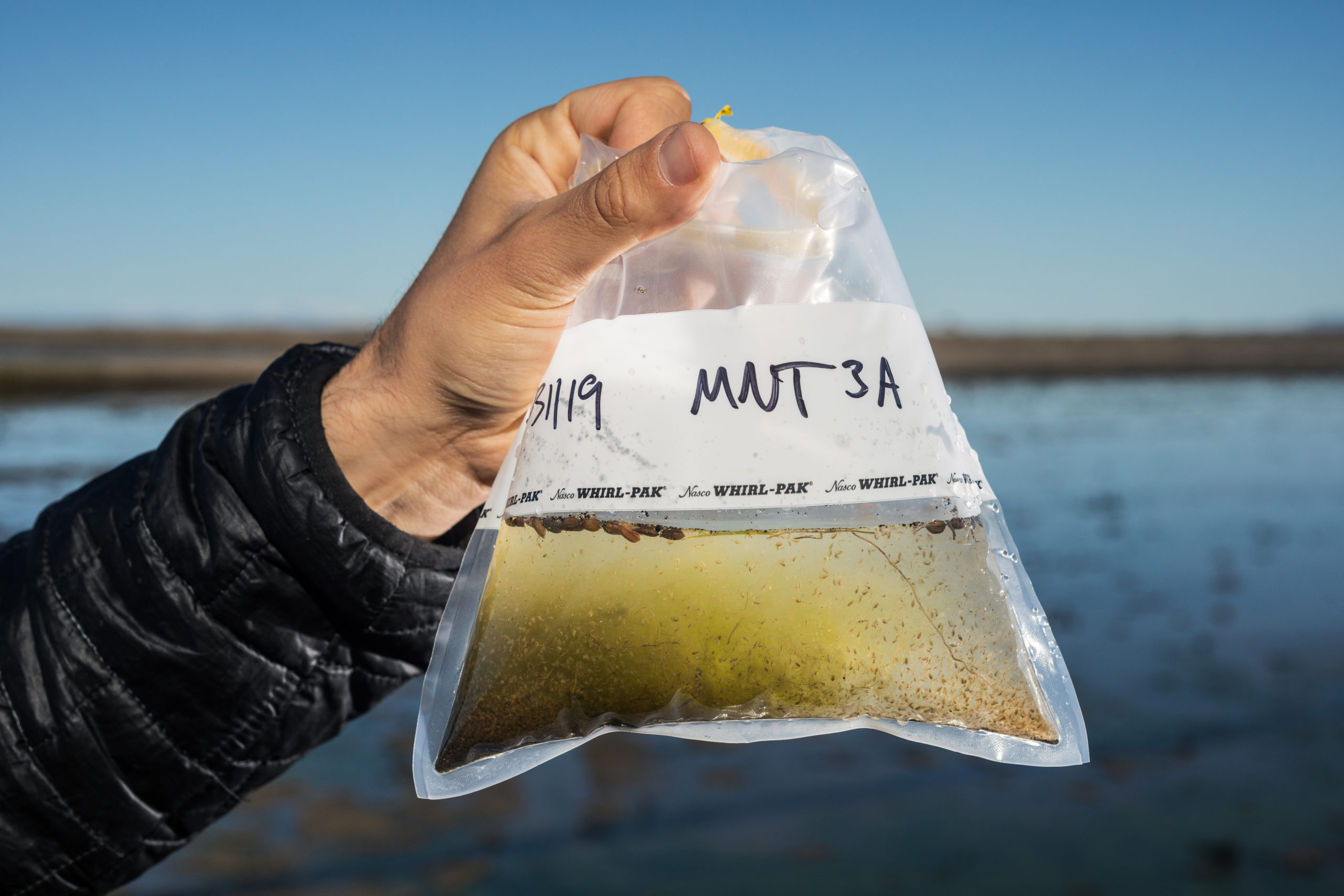
Young salmon flourish in winter-flooded rice fields because these managed floodplains are spectacularly rich in tiny crustaceans, informally called “bugs,” that make terrific food for little fish. “This is one of the key cool findings,” Sommer says. The team learned that building up this abundance of food takes about three weeks. “It’s not enough to get the floodplain wet, you have to keep it wet so bugs can grow and the fish can get big,” says Jacob Katz, a fish ecologist at California Trout who is a co-author of the paper. “That’s the key to survival once they reach the ocean.”
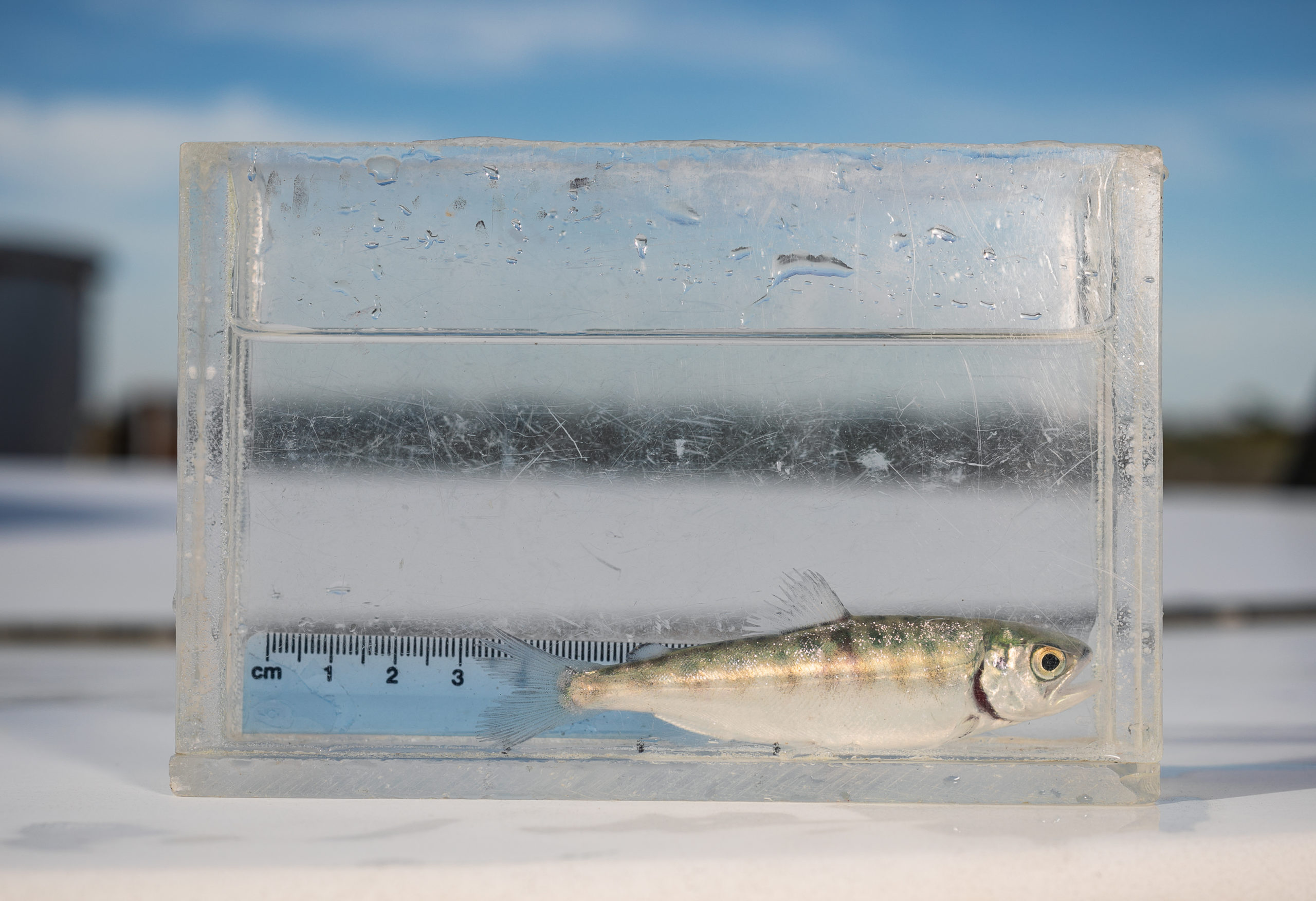
Measuring a young salmon for growth after a stint in the flooded fields. Photo: Jak Wonderly (first published in bioGraphic).
The problem is that the bypass is engineered to drain rapidly. While the land there is inundated when it rains a lot, it drains in a matter of days in drier winters. And that, Katz explains, is when managed floodplains can do the most for young salmon. “The bypass is already a good place to be a fish during wet years,” he says. “The challenge is that during dry years, there’s very little floodplain habitat.”
Managed rice fields could create salmon nurseries in the bypass even when rain is scarce. “Passive restoration is not enough,” Katz says. “We can use infrastructure to mimic historical floodplains.” He envisions augmenting berms to hold floodwater in fields longer and installing operable gates to drain the fields and release fish.
Water sample, bursting with zooplankton, taken from a flooded (dormant) field. Photo: Jak Wonderly
Dos and don’ts
Actively managing fish on fields requires some finesse, however, as the team learned at the height of the 2012-2016 drought. Their experimental flooded rice field was one of the only wetlands for miles around, drawing cormorants, egrets, and great blue herons that picked off the young salmon. “California’s seesaw climate is a challenge for managed wetlands,” Sommer says. “I wouldn’t recommend them during a historical drought.”
Carson Jeffres, an ecologist at the UC Davis Center for Watershed Sciences and another co-author of the paper, chalks this instance of high bird predation up to experience, explaining that we need to understand what works and what doesn’t to inform management actions. The lesson he draws is that “if you have the only spot out there, that’s not good — but a mosaic of floodplain habitats could work.” Boosting the number of flooded fields would give waterbirds more places to hunt, which could lessen the risk of creating predation hotspots.
The team also identified the primary factors critical to the success of managed floodplains. “Flow and connectivity are essential,” Sommer says. “Fish are consistently attracted to inflows and outflows so they can’t be in a pond — you have to keep flow through the field.” In addition, when salmon leave the field, they need a reliable connection to natural habitat so they don’t get stuck or eaten. “You need a clear exit corridor that drains well so fish can move out quickly and freely.” Getting young salmon off fields safely will require nimble hands-on management.
The goal is to balance keeping fish on fields long enough to maximize the floodplain benefits with releasing fish while there’s still enough water to make it to the Delta. That timing can vary widely depending on the weather, from as early as mid-February in a dry year to as late as early June in a wet year. “Ecosystems are not bound by dates on the calendar,” Jeffres says. “You need to look at the system as a whole, track the forecast, and time the migration to conditions.” He proposes a salmon czar to oversee and coordinate these logistics, comparing this to the role waterkeepers play for rivers and streams.
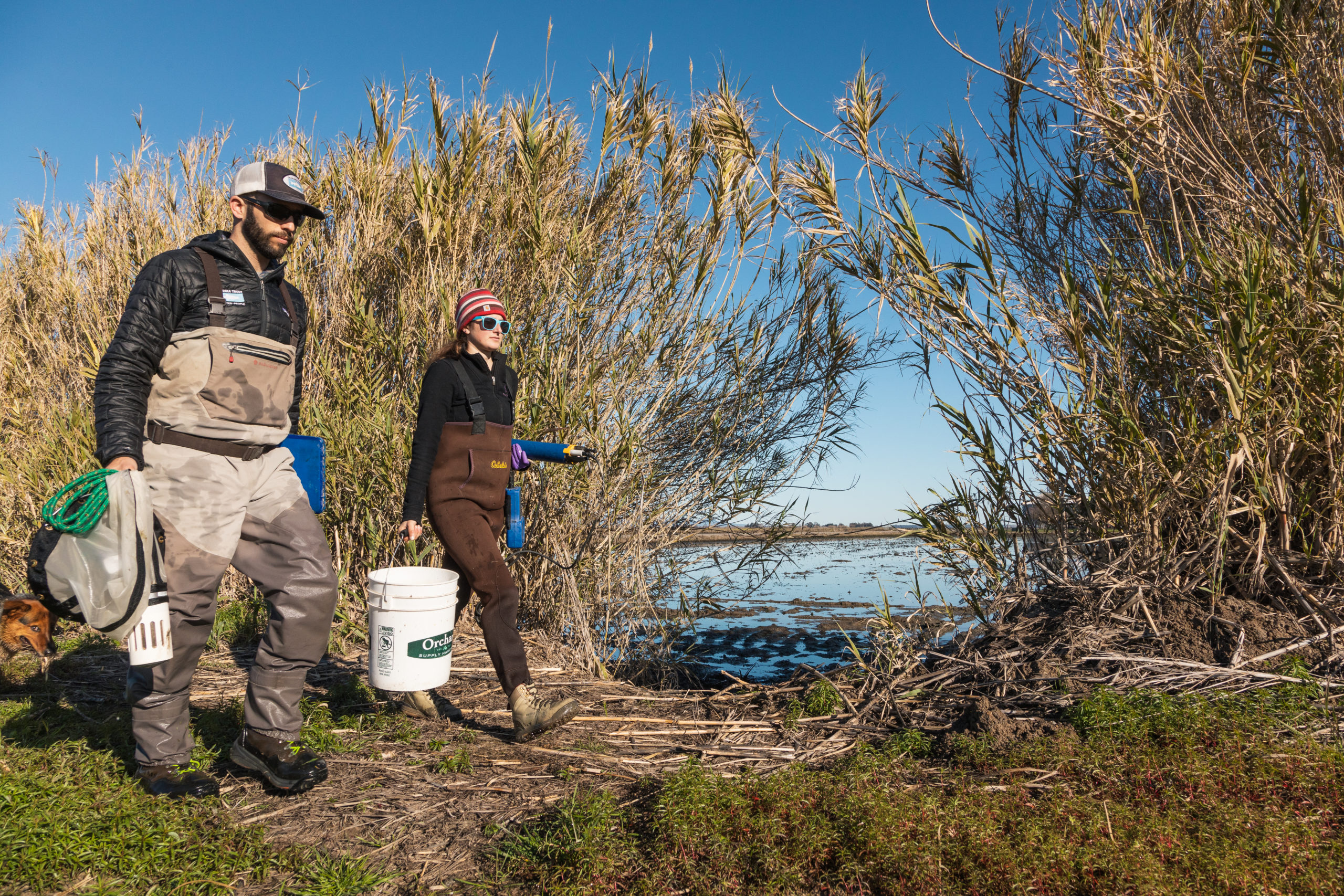
California Trout’s Jacob Katz and Jennifer Kronk collect and sample fish from the floodplains. Video: Jak Wonderly
Wild fish
So far, all the team’s test salmon have been trucked in from hatcheries and poured directly onto flooded fields. Co-author Bjarni Serup would like assurances that wild fish will also benefit from managed floodplains before implementing them on a large scale to the Yolo Bypass. “We’d like to see whether we can get natural-origin fish on and off fields,” says Serup, an environmental scientist at the California Department of Fish and Wildlife. Questions include whether wild salmon will swim to rice fields on their own when the bypass floods, and whether growing up in fields increases their odds of survival to the ocean.
Projects that could help provide answers are underway. A joint California Rice Commission-UC Davis study is fitting field-reared salmon with acoustic tags and tracking their survival after release. Moreover, DWR is installing a 100-foot-wide notch in the Fremont Weir, a two-mile-wide concrete wall at the top of the Yolo Bypass that controls when floodwaters spill in from the Sacramento River. Currently, this happens during big storms and the retrofit will also allow water over the weir during smaller storms. This will flood the bypass more often and could also make it easier for young wild salmon to swim into the bypass and onto managed floodplains. Construction of the $190 million Fremont Weir notch project is scheduled to begin in 2022.
Another unknown is how to design managed floodplains that work for both young and adult salmon on the Yolo Bypass. “It’s like a highway with traffic in two directions,” Serup says. “Young fish are swimming downstream and adults are swimming upstream so there’s potential for conflict in rice fields — water control structures are just not good for adult fish.” Agencies are working to minimize obstacles for migrating adult salmon in the bypass. “They’re high-value individuals,” Serup says. “They’ve returned to spawn.”
Fremont Weir between the Sacramento River and the Yolo Bypass, where a notch is planned to aid fish passage. Video: Jak Wonderly
Scaling up
John Brennan, who owns the Yolo Bypass rice farm that hosted most of the team’s work over the last decade, is more than ready to move forward on managed floodplains. “The weirs are getting notches, and there’s side channel and gravel bed restoration along the Sacramento River from Shasta Dam to Chico,” he says. “What’s missing is floodplains.”
Brennan is all set to create expansive managed floodplains. One reason the bypass drains so speedily is that it slopes five or six feet from the top to the bottom. Brennan proposes building four-foot berms on the low side of farmed lands to keep water from sheeting off, and inundating thousands of acres in the bypass for salmon nurseries. He’d love to see these managed floodplains folded into the Fremont Weir notch project.
“It’s going to be fantastic when it all comes together,” Brennan says. “The ultimate dream is to ramp down the hatcheries and have wild fish take over.”
Look for this new paper in San Francisco Estuary & Watershed Science this fall.
Robin Meadows is an independent science journalist in the San Francisco Bay Area. She’s a water reporter at Maven's Notebook, a California water news site, and contributor to Chemical & Engineering News, Ka Pili Kai, KneeDeep Times, and Scientific American. Robin is also a Pulitzer Center grantee, an Institute for Journalism & Natural Resources fellow, a contributor to The Craft of Science Writing, a mentor with The Open Notebook, and a UC Santa Cruz Science Communication Program graduate. Find her on Tumblr and Twitter.
Our magazine’s media motto for many years has been “Where there’s an estuary, there’s a crowd.” The San Francisco Estuary is a place where people, wildlife, and commerce congregate, and where watersheds, rivers and the ocean meet and mix, creating a place of unusual diversity. In choosing to tell the...
Ever since the state and federal water projects were built in the 1930s and 1940s, California has captured snowmelt in foothill reservoirs, and moved the fresh water from dam releases and river outflows to parched parts of the state via aqueducts hundreds of miles long. A convoluted system of ancient...
Though the Clean Water Act did an amazing job of reducing wastewater and stormwater pollution of the San Francisco Estuary, some contaminants remain thorny problems. Legacy pollutants like mercury washed into the watershed from upstream gold mining, PCBs from old industrial sites, and selenium from agricultural drainage in the San...
Hothouse Earth
By Ariel Rubissow Okamoto
Photo by Megan Nguyen
Nothing could be stranger than sitting in the dark with thousands of suits and heels, watching a parade of promises to decarbonize from companies and countries large and small, reeling from the beauties of big screen rainforests and indigenous necklaces, and getting all choked up.
It was day two of the September 2018 Global Climate Action Summit in San Francisco when I felt it.
At first I wondered if I was simply starstruck. Most of us labor away trying to fix one small corner of the planet or another without seeing the likes of Harrison Ford, Al Gore, Michael Bloomberg, Van Jones, Jerry Brown – or the ministers or mayors of dozens of cities and countries – in person, on stage and at times angry enough to spit. And between these luminaries a steady stream of CEOs, corporate sustainability officers, and pension fund managers promising percentages of renewables and profits in their portfolios dedicated to the climate cause by 2020-2050.
I tried to give every speaker my full attention: the young man of Vuntut Gwichin heritage from the edge of the Yukon’s Arctic National Wildlife Refuge who pleaded with us not to enter his sacred lands with our drills and dependencies; all the women – swathed in bright patterns and head-scarfs – who kept punching their hearts. “My uncle in Uganda would take 129 years to emit the same amount of carbon as an American would in one year,” said Oxfam’s Winnie Byanyima.
“Our janitors are shutting off the lights you leave on,” said Aida Cardenas, speaking about the frontline workers she trains, mostly immigrants, who are excited to be part of climate change solutions in their new country.
The men on the stage, strutting about in feathers and pinstripes, spoke of hopes and dreams, money and power. “The notion that you can either do good or do well is a myth we have to collectively bust,” said New Jersey Governor Phil Murphy whose state is investing heavily in offshore wind farms.
“Climate change isn’t just about risks, it’s about opportunities,” said Blackrock sustainable investment manager Brian Deese.
But it wasn’t all these fine speeches that started the butterflies. Halfway through the second day of testimonials, it was a slight white-haired woman wrapped in an azure pashmina that pricked my tears. One minute she was on the silver screen with Alec Baldwin and the next she taking a seat on stage. She talked about trees. How trees can solve 30% of our carbon reduction problem. How we have to stop whacking them back in the Amazon and start planting them everywhere else. I couldn’t help thinking of Dr. Seuss and his truffala trees. Jane Goodall, over 80, is as fierce as my Lorax. Or my daughter’s Avatar.
Analyzing my take home feeling from the event I realized it wasn’t the usual fear – killer storms, tidal waves, no food for my kids to eat on a half-baked planet – nor a newfound sense of hope – I’ve always thought nature will get along just fine without us. What I felt was relief. People were actually doing something. Doing a lot. And there was so much more we could do.
As we all pumped fists in the dark, as the presentations went on and on and on because so many people and businesses and countries wanted to STEP UP, I realized how swayed I had let myself be by the doomsday news mill.
“We must be like the river, “ said a boy from Bangladesh named Risalat Khan, who had noticed our Sierra watersheds from the plane. “We must cut through the mountain of obstacles. Let’s be the river!”
Or as Harrison Ford less poetically put it: “Let’s turn off our phones and roll up our sleeves and kick this monster’s ass.”
4th California Climate Change Assessment Blues
by Isaac Pearlman
Since California’s last state-led climate change assessment in 2012, the Golden State has experienced a litany of natural disasters. This includes four years of severe drought from 2012 to 2016, an almost non-existent Sierra Nevada snowpack in 2014-2015 costing $2.1 billion in economic losses, widespread Bay Area flooding from winter 2017 storms, and extremely large and damaging wildfires culminating with this year’s Mendocino Complex fire achieving the dubious distinction of the largest in state history. California’s most recent climate assessment, released August 27th, predicts that for the state and the Bay Area, we can expect even more in the future.
The California state government first began assessing climate impacts formally in 2006, due to an executive order by Governor Schwarzenegger. California’s latest iteration and its fourth overall, includes a dizzying array of 44 technical reports; three topical studies on climate justice, tribal and indigenous communities, and the coast and ocean; as well as nine region-specific analyses.
The results are alarming for our state’s future: an estimated four to five feet of sea level rise and loss of one to two-thirds of Southern California beaches by 2100, a 50 percent increase in wildfires over 25,000 acres, stronger and longer heat waves, and infrastructure like airports, wastewater treatment plants, rail and roadways increasingly likely to suffer flooding.
For the first time, California’s latest assessment dives into climate consequences on a regional level. Academics representing nine California regions spearheaded research and summarized the best available science on the variable heat, rain, flooding and extreme event consequences for their areas. For example, the highest local rate of sea level rise in the state is at the rapidly subsiding Humboldt Bay. In San Diego county, the most biodiverse in all of California, preserving its many fragile and endangered species is an urgent priority. Francesca Hopkins from UC Riverside found that the highest rate of childhood asthma in the state isn’t an urban smog-filled city but in the Imperial Valley, where toxic dust from Salton Sea disaster chokes communities – and will only become worse as higher temperatures and less water due to climate change dry and brittle the area.
According to the Bay Area Regional Report, since 1950 the Bay Area has already increased in temperature by 1.7 degrees Fahrenheit and local sea level is eight inches higher than it was one hundred years ago. Future climate will render the Bay Area less suitable for our evergreen redwood and fir forests, and more favorable for tolerant chaparral shrub land. The region’s seven million people and $750 billion economy (almost one-third of California’s total) is predicted to be increasingly beset by more “boom and bust” irregular wet and very dry years, punctuated by increasingly intense and damaging storms.
Unsurprisingly, according to the report the Bay Area’s intensifying housing and equity problems have a multiplier affect with climate change. As Bay Area housing spreads further north, south, and inland the result is higher transportation and energy needs for those with the fewest resources available to afford them; and acute disparity in climate vulnerability across Bay Area communities and populations.
“All Californians will likely endure more illness and be at greater risk of early death because of climate change,” bluntly states the statewide summary brochure for California’s climate assessment. “[However] vulnerable populations that already experience the greatest adverse health impacts will be disproportionately affected.”
“We’re much better at being reactive to a disaster than planning ahead,” said UC Berkeley professor and contributing author David Ackerly at a California Adaptation Forum panel in Sacramento on August 27th. “And it is vulnerable communities that suffer from those disasters. How much human suffering has to happen before it triggers the next round of activity?”
The assessment’s data is publicly available online at “Cal-adapt,” where Californians can explore projected impacts for their neighborhoods, towns, and regions.


 The results are alarming for our state’s future: an estimated four to five feet of sea level rise and loss of one to two-thirds of Southern California beaches by 2100, a 50 percent increase in wildfires over 25,000 acres, stronger and longer heat waves, and infrastructure like airports, wastewater treatment plants, rail and roadways increasingly likely to suffer flooding.