After four of California’s driest years on record, the rain we’ve gotten this winter is hardly a drought buster. But it’s still a relief. Just a year ago, our “wet” season was so dry that state water officials panicked.
Major reservoirs were drawn way down, and record-low snowpack would limit replenishment to a trickle. Water managers worried about the hot, dry months. Would reservoirs still hold enough for freshwater releases to keep saltwater from pushing deep into the Sacramento-San Joaquin Delta, contaminating water supplies to cities and farms? So they built a barrier to block salt instead.
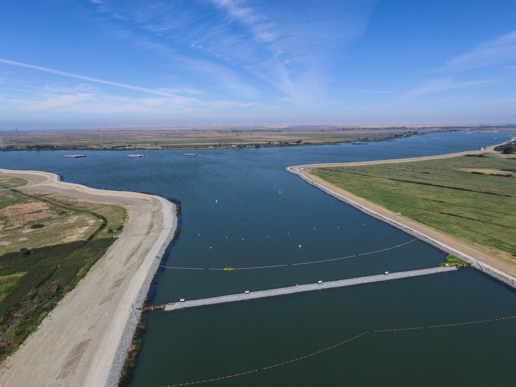
False River emergency salinity barrier. Photo: Bird’s Eye View
Late last spring, when all hope of snow was gone, the state Department of Water Resources (DWR) dropped 150,000 tons of rock across the West False River in the heart of the Delta. Salt barriers are not new. The state first built them in the Delta during the mid-1970s drought — two in 1976 and six in 1977 — and came close again two years ago. “We thought about installing a drought barrier in 2014 but then it rained,” says Eli Ateljevich, a water quality modeler with DWR. “2015 was more urgent. It was full of unpleasant surprises, like even when it rained not much was getting into reservoirs.”
While barriers are nothing new in the Delta, last year’s approach was. Rather than the multiple barriers used before, modeling suggested that a single obstruction would be less disruptive to fish habitat while still being enough to protect water supplies. With all the waterways that thread the Delta, it may come as a surprise that blocking just one could keep the salt at bay. But the West False River is effectively all that stands between the tides and the pumps at the southern end of the Delta. “It’s the biggest, most direct channel for getting salt down toward the pumps,” Ateljevich says. “Other routes are smaller, more meandering.”
West False River is the entrance to Frank’s Tract, a flooded island in the middle of the Delta that looks like a lake. “During drought, salt starts moving in and laps its way up to Frank’s Tract, and then the vigor of the tides injects it in,” Ateljevich says. And from there, it’s just about as close to a straight shot south as you get in the Delta — and water can take several routes. “Once salt makes it to Frank’s Tract, there’s no way to control it and keep it away from the pumps,” he adds. “The drought barrier was an insurance policy.”
One that we needed, it turned out. In the summer of 2015, salt levels just west of the barrier climbed as high as Ateljevich has seen since they’ve been intensively monitored. But inside Frank’s Tract, salt levels held steady and even dropped a bit. “Salt would have been just shy of twice as high without the drought barrier,” he says. “I’d give it an A+ for preventing salinity intrusion.” That said, he says there’s room for improvement: “I’d have liked the water to get fresher faster.” One way to make that happen in the future would be to get the barrier in before the salt intrudes so far into the Delta.
DWR reports that by keeping salt out of Frank’s Tract, the barrier helped us keep about 29 billion gallons in upstream reservoirs, instead of releasing it to flush out the Delta and keep the water drinkable and fit for farming. This much-needed water helped stretch supplies for people and fish until the next rains.
The barrier also provided a deeper look into the inner workings of the Delta. “We don’t often do these kinds of grand experiments on water flow and the ecosystem,” says Sam Harader, a manager with the Delta Stewardship Council’s Delta Science Program. So he and other Delta experts put their heads together to brainstorm likely impacts of the barrier. Then the program funded studies to see what actually happened.
Questions included whether altered flows would affect phytoplankton growth, and whether the barrier would restrict zooplankton — which the endangered Delta smelt (Hypomesus transpacificus) and other fish eat — from reaching the western Delta. Researchers also wondered if the difference in salt levels on either side of the barrier would affect which species of invasive clam lives where: the overbite clam (Corbula amurensis) thrives in brackish water while the Asian clam (Corbicula fluminea) does not.
“Part of the challenge, and really it’s a nearly impossible task, is teasing out the effects of the drought barrier from those of the drought,” Harader says. “Flows were already greatly reduced with or without the barrier.” The researchers are still crunching the numbers to see what it all means.
High speed maps of nitrate [NO3 (mg/L)], chlorophyll-a fluorescence [fCHLA (μg L-1)], and specific conductivity [SPCond (uS/cm) or in simplistic terms saltiness + dissolved solids] measured September 14, 2015 in the Stockton Deep Water Shipping Channel. Color bars show concentration of each measured concentration (green lowest, orange highest). Chlorophyll-a, nitrate and specific conductivity concentrations are all seen increasing in the south channel. Source: USGS, Downing, 2014 pers.commThe Delta Science Program also funded a U.S. Geological Survey (USGS) study that gave snapshots of water quality in the Delta. “We’ll be able to link water quality data with biological data on algae, plankton and fish,” says USGS hydrologist Bryan Downing, who led the study.
While zooming along at 20 miles per hour, the boat used for the study sucked up water samples and pumped them through waterproof case-clad instruments, which took measurements every second. “It’s a great system,” Downing says. “We can cover lots of the Delta in real time, which is important because the Delta is tidal so water there is in nearly constant motion.” A given “parcel” of water can move miles across the Delta in six hours.
Besides confirming that the salt barrier worked, the study yielded a surprise. A set of findings pointed to troubles in the San Joaquin River-Stockton Deep Water Ship Channel, which links Disappointment Slough in the central Delta and to the eastern edge near Stockton.
One trouble was a huge increase in chlorophyll, which is a proxy for algae. And high algae can cause low oxygen, which is bad for fish and other aquatic life. A second trouble was that nitrogen levels tripled in the shipping channel, which makes sense because lots of nutrients can mean lots of algae. Completing the triple whammy, flows appeared to stagnate in the shipping channel. “Water seems to just sit there,” Downing says. “This part of the survey had a huge wow factor — we didn’t realize how extensive it was.”
Six months after the salt barrier went in, the state took it out and ended the grand experiment in the Delta. The barrier was massive at 750 feet across and 120 feet wide at the base, and deconstruction — crane bucket by crane bucket — took nearly 10 weeks during the fall of 2015. We probably won’t need a salt barrier this year because recent rains have begun to refill our reservoirs. But all that rock is sitting in Rio Vista, ready for the next time we need it to keep salt at bay in the Delta.
Robin Meadows is an independent science journalist in the San Francisco Bay Area. She’s a water reporter at Maven's Notebook, a California water news site, and contributor to Chemical & Engineering News, Ka Pili Kai, KneeDeep Times, and Scientific American. Robin is also a Pulitzer Center grantee, an Institute for Journalism & Natural Resources fellow, a contributor to The Craft of Science Writing, a mentor with The Open Notebook, and a UC Santa Cruz Science Communication Program graduate. Find her on Tumblr and Twitter.
Our magazine’s media motto for many years has been “Where there’s an estuary, there’s a crowd.” The San Francisco Estuary is a place where people, wildlife, and commerce congregate, and where watersheds, rivers and the ocean meet and mix, creating a place of unusual diversity. In choosing to tell the...
Ever since the state and federal water projects were built in the 1930s and 1940s, California has captured snowmelt in foothill reservoirs, and moved the fresh water from dam releases and river outflows to parched parts of the state via aqueducts hundreds of miles long. A convoluted system of ancient...
Though the Clean Water Act did an amazing job of reducing wastewater and stormwater pollution of the San Francisco Estuary, some contaminants remain thorny problems. Legacy pollutants like mercury washed into the watershed from upstream gold mining, PCBs from old industrial sites, and selenium from agricultural drainage in the San...
Hothouse Earth
By Ariel Rubissow Okamoto
Photo by Megan Nguyen
Nothing could be stranger than sitting in the dark with thousands of suits and heels, watching a parade of promises to decarbonize from companies and countries large and small, reeling from the beauties of big screen rainforests and indigenous necklaces, and getting all choked up.
It was day two of the September 2018 Global Climate Action Summit in San Francisco when I felt it.
At first I wondered if I was simply starstruck. Most of us labor away trying to fix one small corner of the planet or another without seeing the likes of Harrison Ford, Al Gore, Michael Bloomberg, Van Jones, Jerry Brown – or the ministers or mayors of dozens of cities and countries – in person, on stage and at times angry enough to spit. And between these luminaries a steady stream of CEOs, corporate sustainability officers, and pension fund managers promising percentages of renewables and profits in their portfolios dedicated to the climate cause by 2020-2050.
I tried to give every speaker my full attention: the young man of Vuntut Gwichin heritage from the edge of the Yukon’s Arctic National Wildlife Refuge who pleaded with us not to enter his sacred lands with our drills and dependencies; all the women – swathed in bright patterns and head-scarfs – who kept punching their hearts. “My uncle in Uganda would take 129 years to emit the same amount of carbon as an American would in one year,” said Oxfam’s Winnie Byanyima.
“Our janitors are shutting off the lights you leave on,” said Aida Cardenas, speaking about the frontline workers she trains, mostly immigrants, who are excited to be part of climate change solutions in their new country.
The men on the stage, strutting about in feathers and pinstripes, spoke of hopes and dreams, money and power. “The notion that you can either do good or do well is a myth we have to collectively bust,” said New Jersey Governor Phil Murphy whose state is investing heavily in offshore wind farms.
“Climate change isn’t just about risks, it’s about opportunities,” said Blackrock sustainable investment manager Brian Deese.
But it wasn’t all these fine speeches that started the butterflies. Halfway through the second day of testimonials, it was a slight white-haired woman wrapped in an azure pashmina that pricked my tears. One minute she was on the silver screen with Alec Baldwin and the next she taking a seat on stage. She talked about trees. How trees can solve 30% of our carbon reduction problem. How we have to stop whacking them back in the Amazon and start planting them everywhere else. I couldn’t help thinking of Dr. Seuss and his truffala trees. Jane Goodall, over 80, is as fierce as my Lorax. Or my daughter’s Avatar.
Analyzing my take home feeling from the event I realized it wasn’t the usual fear – killer storms, tidal waves, no food for my kids to eat on a half-baked planet – nor a newfound sense of hope – I’ve always thought nature will get along just fine without us. What I felt was relief. People were actually doing something. Doing a lot. And there was so much more we could do.
As we all pumped fists in the dark, as the presentations went on and on and on because so many people and businesses and countries wanted to STEP UP, I realized how swayed I had let myself be by the doomsday news mill.
“We must be like the river, “ said a boy from Bangladesh named Risalat Khan, who had noticed our Sierra watersheds from the plane. “We must cut through the mountain of obstacles. Let’s be the river!”
Or as Harrison Ford less poetically put it: “Let’s turn off our phones and roll up our sleeves and kick this monster’s ass.”
4th California Climate Change Assessment Blues
by Isaac Pearlman
Since California’s last state-led climate change assessment in 2012, the Golden State has experienced a litany of natural disasters. This includes four years of severe drought from 2012 to 2016, an almost non-existent Sierra Nevada snowpack in 2014-2015 costing $2.1 billion in economic losses, widespread Bay Area flooding from winter 2017 storms, and extremely large and damaging wildfires culminating with this year’s Mendocino Complex fire achieving the dubious distinction of the largest in state history. California’s most recent climate assessment, released August 27th, predicts that for the state and the Bay Area, we can expect even more in the future.
The California state government first began assessing climate impacts formally in 2006, due to an executive order by Governor Schwarzenegger. California’s latest iteration and its fourth overall, includes a dizzying array of 44 technical reports; three topical studies on climate justice, tribal and indigenous communities, and the coast and ocean; as well as nine region-specific analyses.
The results are alarming for our state’s future: an estimated four to five feet of sea level rise and loss of one to two-thirds of Southern California beaches by 2100, a 50 percent increase in wildfires over 25,000 acres, stronger and longer heat waves, and infrastructure like airports, wastewater treatment plants, rail and roadways increasingly likely to suffer flooding.
For the first time, California’s latest assessment dives into climate consequences on a regional level. Academics representing nine California regions spearheaded research and summarized the best available science on the variable heat, rain, flooding and extreme event consequences for their areas. For example, the highest local rate of sea level rise in the state is at the rapidly subsiding Humboldt Bay. In San Diego county, the most biodiverse in all of California, preserving its many fragile and endangered species is an urgent priority. Francesca Hopkins from UC Riverside found that the highest rate of childhood asthma in the state isn’t an urban smog-filled city but in the Imperial Valley, where toxic dust from Salton Sea disaster chokes communities – and will only become worse as higher temperatures and less water due to climate change dry and brittle the area.
According to the Bay Area Regional Report, since 1950 the Bay Area has already increased in temperature by 1.7 degrees Fahrenheit and local sea level is eight inches higher than it was one hundred years ago. Future climate will render the Bay Area less suitable for our evergreen redwood and fir forests, and more favorable for tolerant chaparral shrub land. The region’s seven million people and $750 billion economy (almost one-third of California’s total) is predicted to be increasingly beset by more “boom and bust” irregular wet and very dry years, punctuated by increasingly intense and damaging storms.
Unsurprisingly, according to the report the Bay Area’s intensifying housing and equity problems have a multiplier affect with climate change. As Bay Area housing spreads further north, south, and inland the result is higher transportation and energy needs for those with the fewest resources available to afford them; and acute disparity in climate vulnerability across Bay Area communities and populations.
“All Californians will likely endure more illness and be at greater risk of early death because of climate change,” bluntly states the statewide summary brochure for California’s climate assessment. “[However] vulnerable populations that already experience the greatest adverse health impacts will be disproportionately affected.”
“We’re much better at being reactive to a disaster than planning ahead,” said UC Berkeley professor and contributing author David Ackerly at a California Adaptation Forum panel in Sacramento on August 27th. “And it is vulnerable communities that suffer from those disasters. How much human suffering has to happen before it triggers the next round of activity?”
The assessment’s data is publicly available online at “Cal-adapt,” where Californians can explore projected impacts for their neighborhoods, towns, and regions.

![High speed maps of nitrate [NO3 (mg/L)], chlorophyll-a fluorescence [fCHLA (μg L-1)], and specific conductivity [SPCond (uS/cm) or in simplistic terms saltiness + dissolved solids] measured September 14, 2015 in the Stockton Deep Water Shipping Channel. Color bars show concentration of each measured concentration (green lowest, orange highest). Chlorophyll-a, nitrate and specific conductivity concentrations are all seen increasing in the south channel. Source: USGS, Downing, 2014 pers.comm](https://archive.estuarynews.org/wp-content/uploads/2016/03/Salt-Field-At-Bay-Graphic-Final.jpg)


 The results are alarming for our state’s future: an estimated four to five feet of sea level rise and loss of one to two-thirds of Southern California beaches by 2100, a 50 percent increase in wildfires over 25,000 acres, stronger and longer heat waves, and infrastructure like airports, wastewater treatment plants, rail and roadways increasingly likely to suffer flooding.