Dutch Slough in Oakley, on the southern edge of the Sacramento-San Joaquin Delta, is less than a mile from where biometeorologist Dennis D. Baldocchi (above) grew up on his parents’ orchard and fished with pals in nearby Marsh Creek. In October 2021, the California Department of Water Resources breached the levees here, restoring nutrient-rich tidal flows to degraded ranchland.
Early in the 20th century, Baldocchi’s father grew dry beans and sugar beets on the peat soils of the Delta’s Liberty Island, and his aunt’s family raised asparagus, sugar beets, and corn on Sherman Island. In 1952, his dad started growing almonds and walnuts at the junction of Sellers Avenue and Cypress Road in Oakley.
“My family mined the Delta for agriculture, which led to subsidence and contributed to climate change,” says Baldocchi, a University of California, Berkeley, professor whose current research focus is the ability of restored tidal wetlands to sequester carbon. “Now my generation is trying to use science to stop it.”
Beginning in the mid-19th century, virtually all of the Delta’s wetlands were drained and transformed into ranches and fertile farms via the construction of a vast network of levees. Without natural tidal flows, the land between those levees — with rich peat soil up to 50 feet deep — has been sinking rapidly, as much as 30 feet in some places. “Soil microbes eat carbon compounds and convert them into energy and carbon dioxide gas, which causes the land to collapse and subside,” Baldocchi says.
Of the Delta’s 740,000 acres, about two-thirds are in agriculture; top crops include corn for forage, alfalfa, wheat, wine grapes, and processing tomatoes. Global food production contributes an estimated 21% to 37% of the greenhouse gases that are warming the planet, including huge releases of carbon when vast aquatic ecosystems like the Delta are transformed for agriculture. Baldocchi and colleagues are now trying to figure out if bringing back tidal wetlands like the one at Dutch Slough can help reverse these processes.
“These are some of the most productive ecosystems in the world,” Baldocchi says. “We want this to be a greenhouse gas sink to stop global warming.”
Lab for Restoration Strategies
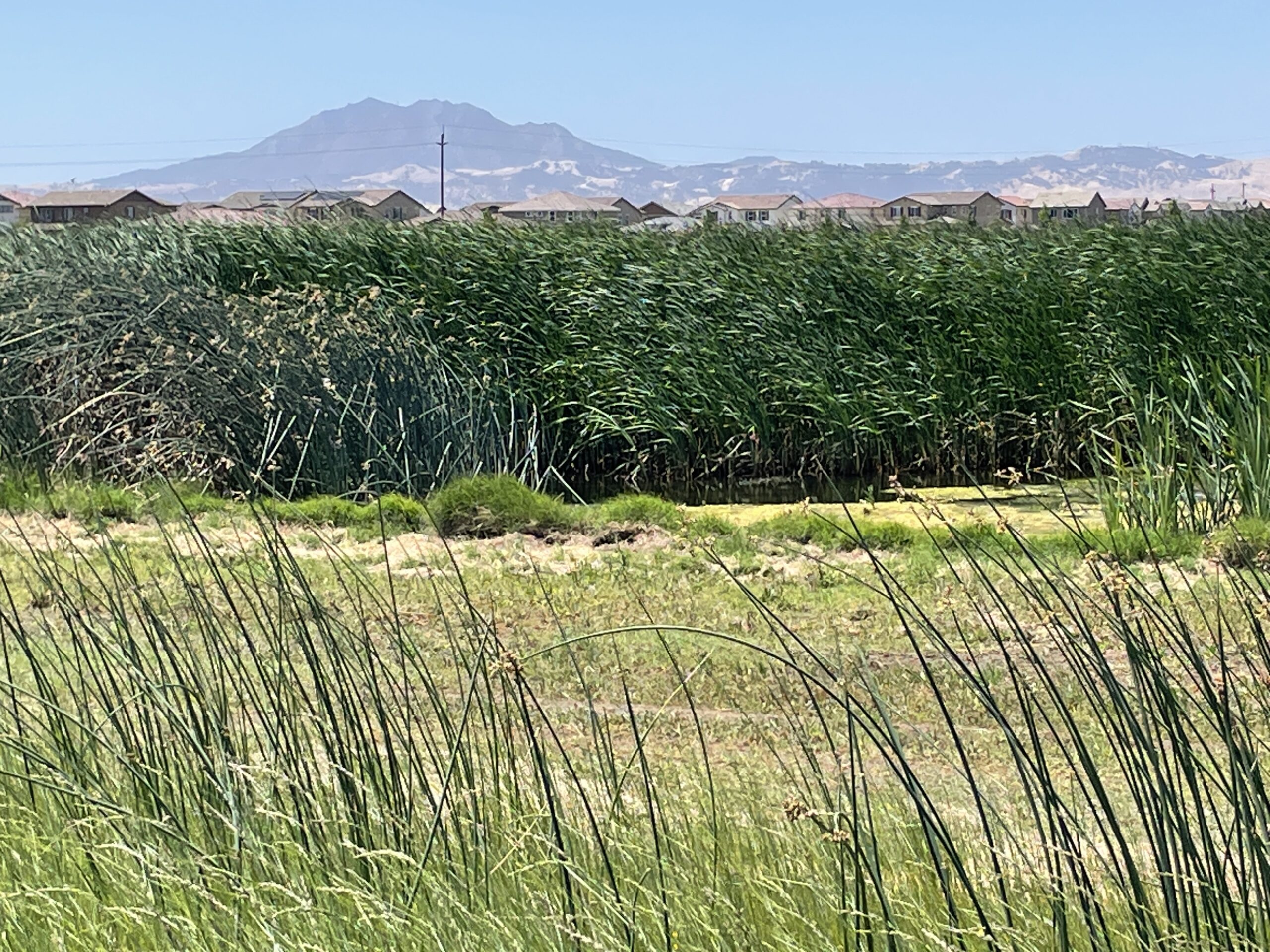
When Baldocchi was growing up in the 1970s, Oakley was a hamlet of about 1,300 people. Now it’s a growing city of nearly 44,000, east of the Antioch Bridge. Before the city of Oakley incorporated in 2002, Contra Costa County had slated 4,500 homes for the Dutch Slough site, precariously below sea level; now a newish subdivision skirts the upland area above the flood and tide lines on its southern border.
Wetlands and suburbs co-exist in the shadow of Mt. Diablo. Photo: Janet Byron
The $71 million Dutch Slough Tidal Restoration Project is a laboratory for ecosystem restoration strategies. When complete it will include tidal wetlands, marsh managed for the elusive black rail, nest-tree plantings for raptors, preservation of Indigenous lands and an historic vineyard, and a 55-acre community park with regional access trails.
Katherine Bandy, who manages the project for the Department of Water Resources, says that Baldocchi’s research is important because Dutch Slough uniquely functions as both a freshwater and tidal marsh. “Most freshwater marshes are impounded, and most tidal wetlands are saline,” she says. “This type of tidal marsh hasn’t been widely studied before.”
In the years before tidal action was restored, portions of the land were graded and the Department of Water Resources and River Partners planted 25,000 native tule plugs and 50,000 shrubs and trees. Just seven months after the levee was breached, the marsh is thickly vegetated with reeds and sedges swaying in the breeze; the trees and shrubs will need more time to become established. With restored tidal action, new soil is accreting at a rate of two to three centimeters per year, Baldocchi says.
The marsh is humming with wildlife. Red-winged blackbirds cackle and trill in the tule, egrets and a great blue heron fish in the channels, a pintail alights from the marsh, turkey vultures cruise overhead, and killdeer clown around in the upland area. This reporter was delighted to see an otter waddle across the levee.
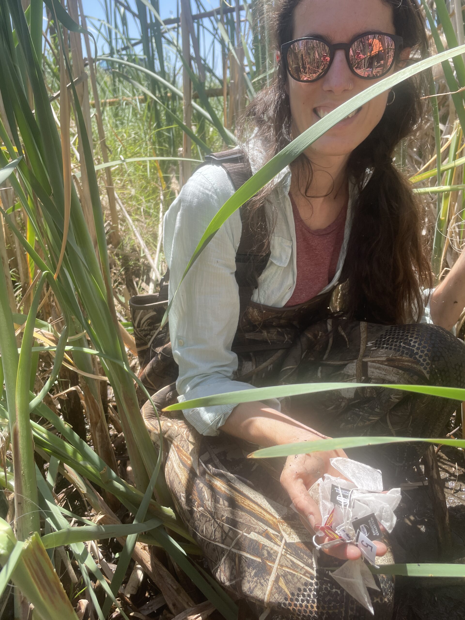
Ariane Arias-Ortiz on teabag patrol. Photo: Janet Byron
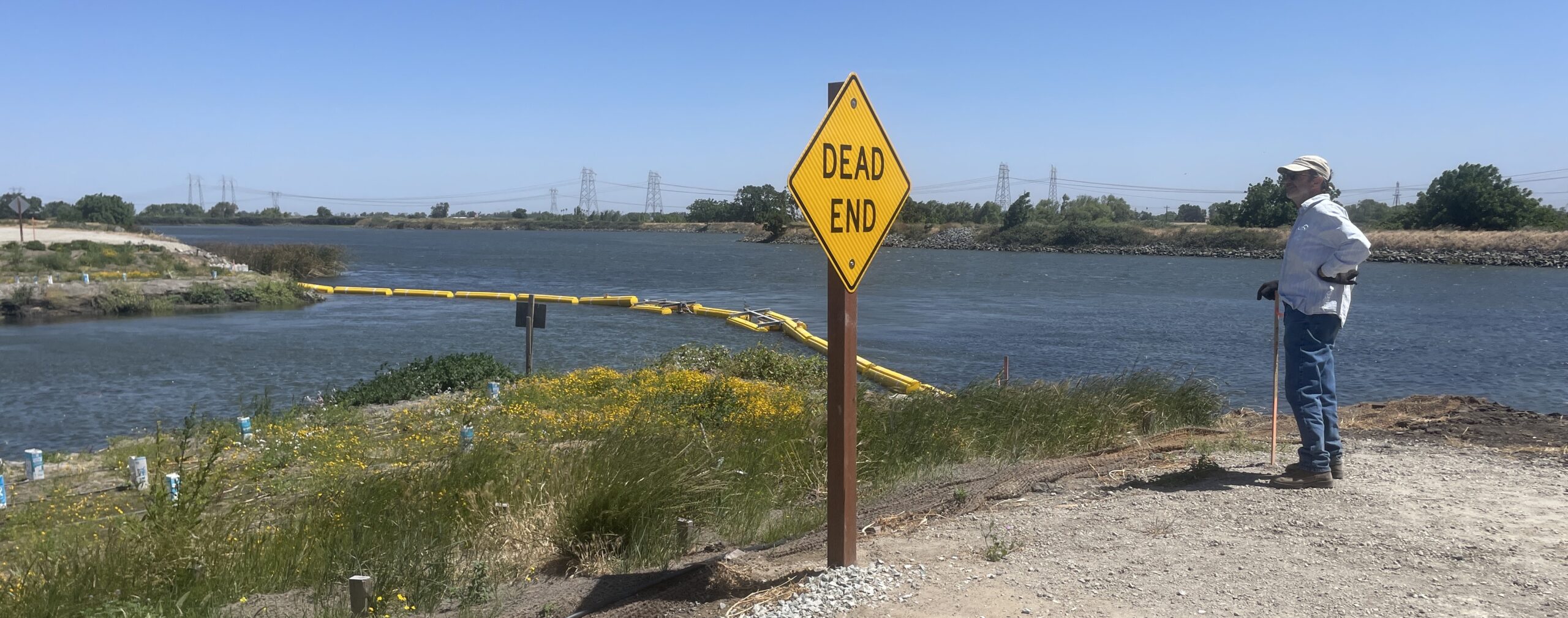
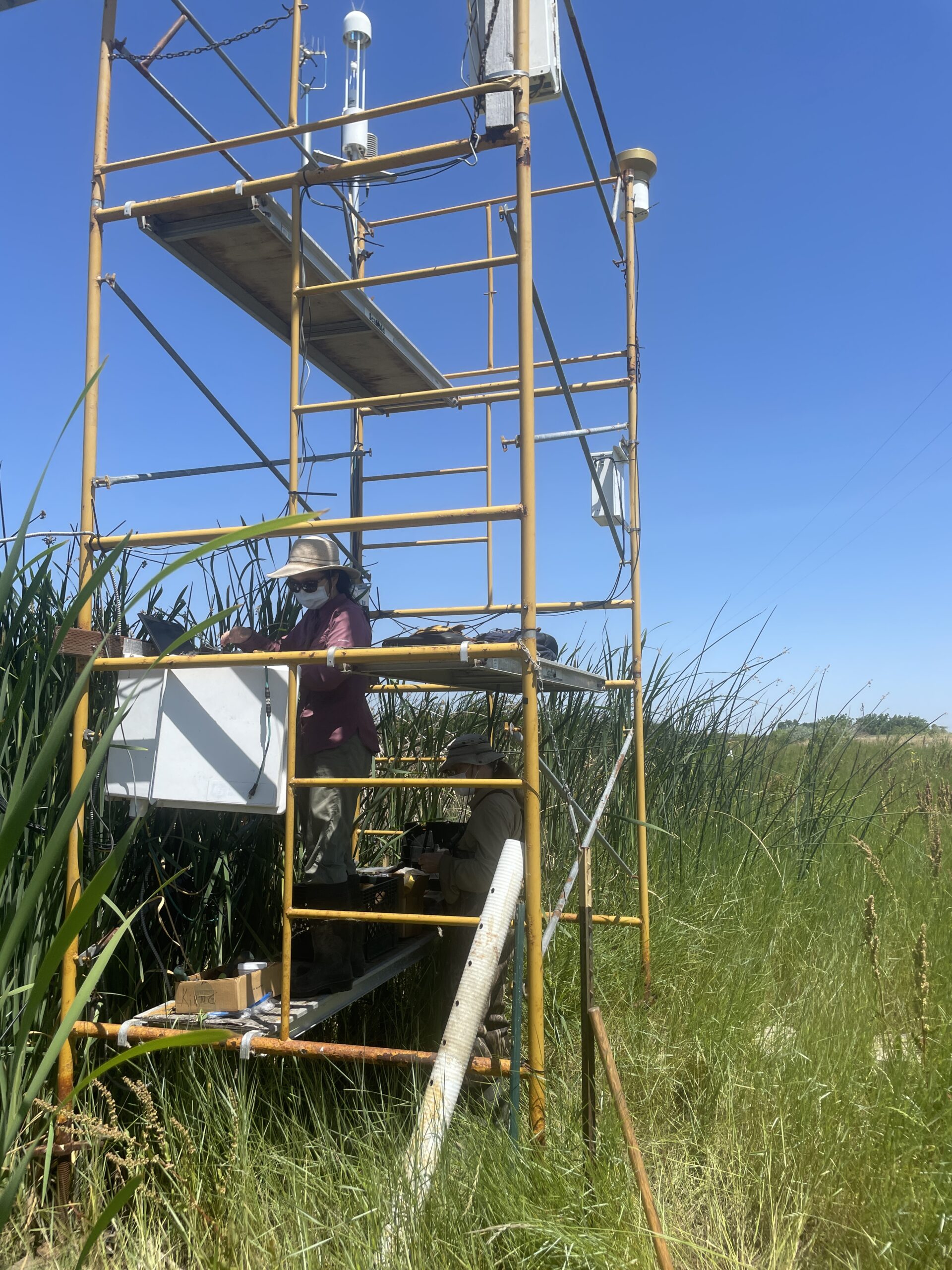
On a clear spring morning, Baldocchi shows where the Department of Water Resources breached the levee, with a DEAD END sign marking the end of the road. Nearby, UC Berkeley Biometeorology Lab technician Daphne Szutu is up on the weather station downloading data, while fellow technician Joe Verfaillie makes some adjustments to a narrow walkway out into the marsh.
Crouching among the tules, Ariane Arias-Ortiz, a UC Berkeley postdoctoral researcher and recent NOAA Climate and Global Change fellow, checks the teabag index samplers. A few weeks ago, she and Baldocchi enlisted 5th and 6th graders at nearby Knightsen Elementary School in a citizen-science project that is burying household teabags in wetlands all over the world to measure how well they decompose carbon.
“By calculating the weight loss of the teabag after three months, students can estimate the rate of decomposition of plant material by microbes in wetland soils and compare it to that of other soils, such as their school garden,” Arias-Ortiz says.
Carbon Uptake by Marsh Plants
Baldocchi’s research program uses the tools of biometeorology — the study of relationships between living things and atmospheric phenomena — to gauge how well plants in restored marshes take carbon out of the air and return it to the soil, and how the reintroduction of aquatic plants influences overall greenhouse gas levels.
Here at Dutch Slough and other restored tidal wetlands in the Delta, his team is continuously monitoring vertical fluxes of carbon dioxide and methane between water, soil, plants, and the atmosphere, as well as lateral fluxes of carbon dioxide as tides flow in and out. “We’re sniffing the delta,” Baldocchi says. “We can monitor pockets of air moving up and down and across the marsh. Our methods allow us to measure the breathing of the biosphere.” A three-year, $700,000 grant from the Delta Science Program is helping to fund the work.
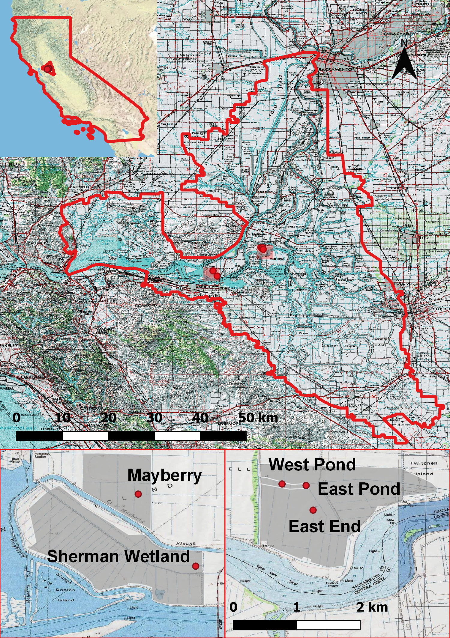
Five restored wetland sites on Sherman and Twitchell Islands in the Sacramento–San Joaquin Delta, which were analyzed by Baldocchi and colleagues in PLOS ONE, March 25, 2021. Site locations are marked (top) and enlarged (bottom) to show wetland areas (shaded grey) and instrument tower locations (red points). Courtesy: PLOS ONE
Baldocchi’s current research at Dutch Slough and Hill Slough — a new wetland at Suisun Marsh in Solano County that was intentionally breached about the same time — builds on more than a decade of studies measuring the exchange of greenhouse gases on agricultural lands that have been restored as wetlands.
In a 2021 article in the journal PLOS ONE, Baldocchi and colleagues reported on 21 site-years of carbon flux measurements on five restored freshwater-to-brackish wetlands at the Delta’s Twitchell Island and Sherman Island, which had been restored between three and 23 years ago (see figure).
Researchers found that a minimum of 55% of vegetation cover was needed for wetlands to become carbon sinks, and site-specific conditions including water levels, soil nutrients, and planting methods mattered in terms of how well they captured carbon from the atmosphere.
Measuring Greenhouse Gas Balances
Another Baldocchi study published in 2019 compared the amounts of carbon dioxide and methane that were absorbed and emitted by restored wetlands and drained agricultural lands, also at Sherman and Twitchell islands, for 36 site-years.
While sequestering carbon, natural and restored wetlands also release methane, which is created when soil microbes decompose plant matter under the anaerobic, or low-oxygen, conditions of land that is under water. A potent greenhouse gas, methane effectively traps 25 times more heat in the Earth’s atmosphere than carbon dioxide.
After the initial year of restoration, Delta wetlands extracted an average of 339 grams per square meter (± 55 g/m2) of carbon dioxide each year, while the agricultural sites released between 200 and 1,541 g/m2 of carbon dioxide into the atmosphere annually.
Daphne Szutu collects data on the Dutch Slough weather station. Photo: Janet Byron
But the Delta wetlands also released methane at an average rate of 44 g/m2 per year, with significant variability among sites due to water management, soil nutrient levels, and other conditions. The agricultural sites, which included rice, pasture, corn, and alfalfa, released up to 12 g/m2 of methane per year, and none in some locations.
In a subsequent analysis, Baldocchi and colleagues found that the restored wetlands quickly became carbon sinks once vegetation was established, and, if well-maintained, had the potential to be net greenhouse gas sinks within a century, and likely decades sooner. “The reality is these wetlands are very effective carbon sinks, and as time goes on the methane production and its release into the atmosphere will go down,” Baldocchi says.
In addition to understanding the potential of restored wetlands to mitigate climate change, the biometeorology researchers are learning which restoration, water management, and planting strategies work best to provide long-term benefits for marsh ecosystems. “The Dutch Slough project,” Bandy says, “is helping climate scientists to figure out what type of wetlands are the best bang for the buck for restoration when it comes to carbon sequestration.”
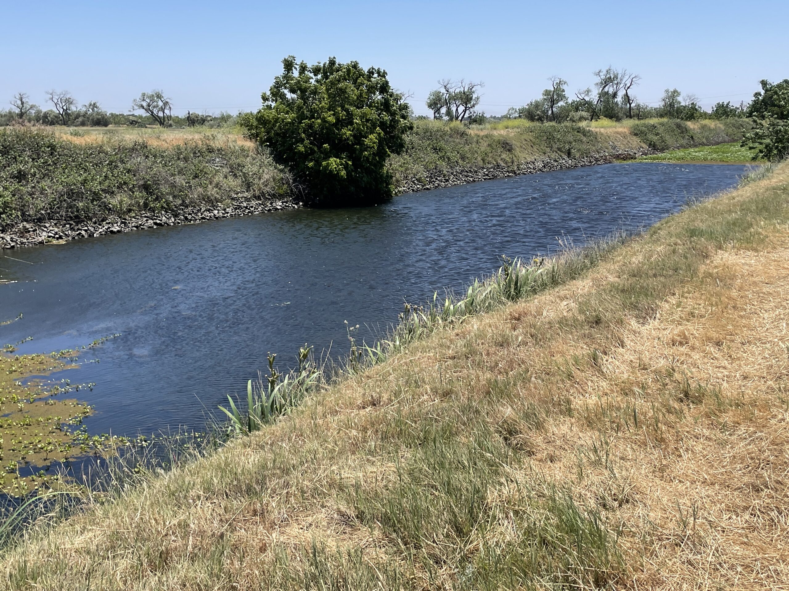
Dutch Slough. Photo: Janet Byron
Mitigating Climate Change
Baldocchi’s studies are finding that Delta wetlands match upland forests in their ability to pull carbon from the atmosphere, providing important evidence to support their inclusion in the state’s carbon-trading markets, a key component of California’s strategy to lower greenhouse gas emissions.
“The research that is being conducted at Dutch Slough will help validate the efficacy of tidal wetlands in providing greenhouse gas benefits in the Delta,” says Michelle Jesperson of the Department of Water Resource’s California EcoRestore program, which seeks to bring back 30,000 acres of Delta wetlands.
Cal EcoRestore is on track to meet this goal, adds Department of Water Resources project manager Charlotte Biggs, with 10,000 acres of wetlands completed, 10,000 acres under construction, and the remaining acreage in planning and permitting.
Back at the Dutch Slough research station, Arias-Ortiz says the UC Biometeorology Lab’s work clearly demonstrates that carbon extracted by marsh plants has immediate benefits for climate mitigation. “As wetlands age, the carbon capture these ecosystems provide exceeds the negative effects of methane emissions, while additionally providing many other valuable services such as the reversal of subsidence and habitat for fish and wildlife,” she explains. “The atmospheric carbon taken up by plants is being buried in the ground, and most of it stays locked up there.”
Top image: Baldocchi at the end of one of the levees breached to restore tidal action at Dutch Slough. Photo: Janet Byron
Janet Byron is an independent journalist and editor specializing in science, the environment, and health care. She is co-author of Berkeley Walks (Heyday Books, 2nd ed., 2018), self-guided neighborhood walking tours in America’s most intriguing city, and she currently serves as president of the Berkeley Path Wanderers Association. From 1999 to 2013, she was managing editor of California Agriculture, the peer-reviewed journal published by the University of California Division of Agriculture and Natural Resources.
Our magazine’s media motto for many years has been “Where there’s an estuary, there’s a crowd.” The San Francisco Estuary is a place where people, wildlife, and commerce congregate, and where watersheds, rivers and the ocean meet and mix, creating a place of unusual diversity. In choosing to tell the...
Ever since the state and federal water projects were built in the 1930s and 1940s, California has captured snowmelt in foothill reservoirs, and moved the fresh water from dam releases and river outflows to parched parts of the state via aqueducts hundreds of miles long. A convoluted system of ancient...
Though the Clean Water Act did an amazing job of reducing wastewater and stormwater pollution of the San Francisco Estuary, some contaminants remain thorny problems. Legacy pollutants like mercury washed into the watershed from upstream gold mining, PCBs from old industrial sites, and selenium from agricultural drainage in the San...
Hothouse Earth
By Ariel Rubissow Okamoto
Photo by Megan Nguyen
Nothing could be stranger than sitting in the dark with thousands of suits and heels, watching a parade of promises to decarbonize from companies and countries large and small, reeling from the beauties of big screen rainforests and indigenous necklaces, and getting all choked up.
It was day two of the September 2018 Global Climate Action Summit in San Francisco when I felt it.
At first I wondered if I was simply starstruck. Most of us labor away trying to fix one small corner of the planet or another without seeing the likes of Harrison Ford, Al Gore, Michael Bloomberg, Van Jones, Jerry Brown – or the ministers or mayors of dozens of cities and countries – in person, on stage and at times angry enough to spit. And between these luminaries a steady stream of CEOs, corporate sustainability officers, and pension fund managers promising percentages of renewables and profits in their portfolios dedicated to the climate cause by 2020-2050.
I tried to give every speaker my full attention: the young man of Vuntut Gwichin heritage from the edge of the Yukon’s Arctic National Wildlife Refuge who pleaded with us not to enter his sacred lands with our drills and dependencies; all the women – swathed in bright patterns and head-scarfs – who kept punching their hearts. “My uncle in Uganda would take 129 years to emit the same amount of carbon as an American would in one year,” said Oxfam’s Winnie Byanyima.
“Our janitors are shutting off the lights you leave on,” said Aida Cardenas, speaking about the frontline workers she trains, mostly immigrants, who are excited to be part of climate change solutions in their new country.
The men on the stage, strutting about in feathers and pinstripes, spoke of hopes and dreams, money and power. “The notion that you can either do good or do well is a myth we have to collectively bust,” said New Jersey Governor Phil Murphy whose state is investing heavily in offshore wind farms.
“Climate change isn’t just about risks, it’s about opportunities,” said Blackrock sustainable investment manager Brian Deese.
But it wasn’t all these fine speeches that started the butterflies. Halfway through the second day of testimonials, it was a slight white-haired woman wrapped in an azure pashmina that pricked my tears. One minute she was on the silver screen with Alec Baldwin and the next she taking a seat on stage. She talked about trees. How trees can solve 30% of our carbon reduction problem. How we have to stop whacking them back in the Amazon and start planting them everywhere else. I couldn’t help thinking of Dr. Seuss and his truffala trees. Jane Goodall, over 80, is as fierce as my Lorax. Or my daughter’s Avatar.
Analyzing my take home feeling from the event I realized it wasn’t the usual fear – killer storms, tidal waves, no food for my kids to eat on a half-baked planet – nor a newfound sense of hope – I’ve always thought nature will get along just fine without us. What I felt was relief. People were actually doing something. Doing a lot. And there was so much more we could do.
As we all pumped fists in the dark, as the presentations went on and on and on because so many people and businesses and countries wanted to STEP UP, I realized how swayed I had let myself be by the doomsday news mill.
“We must be like the river, “ said a boy from Bangladesh named Risalat Khan, who had noticed our Sierra watersheds from the plane. “We must cut through the mountain of obstacles. Let’s be the river!”
Or as Harrison Ford less poetically put it: “Let’s turn off our phones and roll up our sleeves and kick this monster’s ass.”
4th California Climate Change Assessment Blues
by Isaac Pearlman
Since California’s last state-led climate change assessment in 2012, the Golden State has experienced a litany of natural disasters. This includes four years of severe drought from 2012 to 2016, an almost non-existent Sierra Nevada snowpack in 2014-2015 costing $2.1 billion in economic losses, widespread Bay Area flooding from winter 2017 storms, and extremely large and damaging wildfires culminating with this year’s Mendocino Complex fire achieving the dubious distinction of the largest in state history. California’s most recent climate assessment, released August 27th, predicts that for the state and the Bay Area, we can expect even more in the future.
The California state government first began assessing climate impacts formally in 2006, due to an executive order by Governor Schwarzenegger. California’s latest iteration and its fourth overall, includes a dizzying array of 44 technical reports; three topical studies on climate justice, tribal and indigenous communities, and the coast and ocean; as well as nine region-specific analyses.
The results are alarming for our state’s future: an estimated four to five feet of sea level rise and loss of one to two-thirds of Southern California beaches by 2100, a 50 percent increase in wildfires over 25,000 acres, stronger and longer heat waves, and infrastructure like airports, wastewater treatment plants, rail and roadways increasingly likely to suffer flooding.
For the first time, California’s latest assessment dives into climate consequences on a regional level. Academics representing nine California regions spearheaded research and summarized the best available science on the variable heat, rain, flooding and extreme event consequences for their areas. For example, the highest local rate of sea level rise in the state is at the rapidly subsiding Humboldt Bay. In San Diego county, the most biodiverse in all of California, preserving its many fragile and endangered species is an urgent priority. Francesca Hopkins from UC Riverside found that the highest rate of childhood asthma in the state isn’t an urban smog-filled city but in the Imperial Valley, where toxic dust from Salton Sea disaster chokes communities – and will only become worse as higher temperatures and less water due to climate change dry and brittle the area.
According to the Bay Area Regional Report, since 1950 the Bay Area has already increased in temperature by 1.7 degrees Fahrenheit and local sea level is eight inches higher than it was one hundred years ago. Future climate will render the Bay Area less suitable for our evergreen redwood and fir forests, and more favorable for tolerant chaparral shrub land. The region’s seven million people and $750 billion economy (almost one-third of California’s total) is predicted to be increasingly beset by more “boom and bust” irregular wet and very dry years, punctuated by increasingly intense and damaging storms.
Unsurprisingly, according to the report the Bay Area’s intensifying housing and equity problems have a multiplier affect with climate change. As Bay Area housing spreads further north, south, and inland the result is higher transportation and energy needs for those with the fewest resources available to afford them; and acute disparity in climate vulnerability across Bay Area communities and populations.
“All Californians will likely endure more illness and be at greater risk of early death because of climate change,” bluntly states the statewide summary brochure for California’s climate assessment. “[However] vulnerable populations that already experience the greatest adverse health impacts will be disproportionately affected.”
“We’re much better at being reactive to a disaster than planning ahead,” said UC Berkeley professor and contributing author David Ackerly at a California Adaptation Forum panel in Sacramento on August 27th. “And it is vulnerable communities that suffer from those disasters. How much human suffering has to happen before it triggers the next round of activity?”
The assessment’s data is publicly available online at “Cal-adapt,” where Californians can explore projected impacts for their neighborhoods, towns, and regions.


 The results are alarming for our state’s future: an estimated four to five feet of sea level rise and loss of one to two-thirds of Southern California beaches by 2100, a 50 percent increase in wildfires over 25,000 acres, stronger and longer heat waves, and infrastructure like airports, wastewater treatment plants, rail and roadways increasingly likely to suffer flooding.